
|
m Robot - Moving category Rivers of Ohio to Category:Rivers and streams of Ohio per CFDatWikipedia:Categories for discussion/Log/2015 December 9.
|
Rescuing 1 sources and tagging 0 as dead.) #IABot (v2.0.9.3) (Eastmain - 13424
|
||
| (16 intermediate revisions by 12 users not shown) | |||
| Line 1: | Line 1: | ||
{{ |
{{Infobox river |
||
| |
| name = Saint Marys River |
||
| |
| image = St Marys River Bluffton Road Fort Wayne.jpg |
||
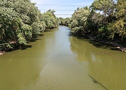
| image_caption = The St. Marys River in [[Fort Wayne, Indiana]] |
|||
| ⚫ | |||
|image_size |
| image_size = <!-- Unnecessary. Size is automatic. --> |
||
| |
| map = Maumeerivermap.png |
||
|map_caption |
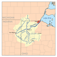
| map_caption = Map of the Maumee River watershed showing the St. Marys River |
||
| subdivision_type1 = Country |
|||
| ⚫ |
| |
||
| subdivision_name1 = United States |
|||
| ⚫ |
| |
||
| subdivision_type2 = States |
|||
| ⚫ |
|mouth |
||
| subdivision_name2 = [[Ohio]], [[Indiana]] |
|||
| ⚫ |
| |
||
| ⚫ | |||
| ⚫ |
| |
||
| source1_location = near [[St. Marys, Ohio]] |
|||
|elevation_ft = 854 |
|||
| ⚫ | | source1_coordinates= {{coord|40.5372222|-84.3627778|region:US-IN|format=dms|name=Saint Marys River origin}} |
||
|mouth_elevation_ft = 745 |
|||
| ⚫ | | mouth = confluence with the [[St. Joseph River (Maumee River tributary)|St. Joseph River]] to form the [[Maumee River]] |
||
|length_mi = |
|||
| mouth_location = [[Fort Wayne, Indiana]] |
|||
| ⚫ |
| |
||
| ⚫ | | mouth_coordinates = {{coord|41.0833333|-85.1322222|region:US-IN|format=dms|name=Saint Marys River mouth|display=inline,title}} |
||
| ⚫ | |||
| ⚫ | | progression = St. Marys River → Maumee River → Lake Erie → Great Lakes → St Lawrence River → Gulf of St. Lawrence |
||
| source1_elevation = {{convert|854|ft|m|abbr=on}} |
|||
| mouth_elevation = {{convert|745|ft|m|abbr=on}} |
|||
| length = {{convert|99|mi|km}} |
|||
| basin_size = {{convert|793.1|sqmi|sqkm}}<ref name=WBD_area>U.S. Geological Survey. Watershed Boundary Dataset, area data covering St. Marys River watershed (8-digit [[Hydrologic Unit Code]] 04100004), viewed in [http://viewer.nationalmap.gov/viewer/ The National Map], accessed 2020-05-26.</ref> |
|||
| ⚫ | | custom_label = [[Geographic Names Information System|GNIS]] ID |
||
| ⚫ | |||
}} |
}} |
||
{{GeoGroup}} |
{{GeoGroup}} |
||
The '''St. Marys River''' ([[Shawnee language|Shawnee]]: |
The '''St. Marys River''' ([[Shawnee language|Shawnee]]: '''Kokothikithiipi''',<ref>{{Cite web |
||
| |
|title = Shawnees Webpage |
||
| |
|work = Shawnee's Reservation |
||
| |
|access-date = 2013-04-26 |
||
| |
|year = 1997 |
||
| |
|url = http://reocities.com/SouthBeach/Cove/8286/speach.html |
||
|url-status = dead |
|||
| ⚫ |
}}</ref>) is a {{convert|99|mi|km|adj=mid|-long}}<ref name=NHD>U.S. Geological Survey. National Hydrography Dataset high-resolution flowline data. [http://viewer.nationalmap.gov/viewer/ The National Map], accessed May 19, 2011</ref> tributary of the [[Maumee River]] in |
||
|archive-url = https://web.archive.org/web/20130502054932/http://reocities.com/SouthBeach/Cove/8286/speach.html |
|||
|archive-date = 2013-05-02 |
|||
| ⚫ | |||
| ⚫ | }}</ref> in [[Miami-Illinois language|Miami-Illinois]]: '''Nameewa siipiiwi''')<ref>{{Cite web |url=https://myaamiadictionary.org/dictionary2015/search/search.php?search=river&stem=stem&inflected=inflected&sentences=sentences&command=command&language=both&website=t |title=myaamiaatawaakani {{!}} Myaamia Dictionary |access-date=2017-04-22 |archive-date=2017-08-30 |archive-url=https://web.archive.org/web/20170830003624/https://myaamiadictionary.org/dictionary2015/search/search.php?search=river&stem=stem&inflected=inflected&sentences=sentences&command=command&language=both&website=t |url-status=dead }}</ref> is a {{convert|99|mi|km|adj=mid|-long}}<ref name=NHD>U.S. Geological Survey. National Hydrography Dataset high-resolution flowline data. [http://viewer.nationalmap.gov/viewer/ The National Map], accessed May 19, 2011</ref> tributary of the [[Maumee River]] (Miami-Illinois: ''Taawaawa siipiiwi'')innorthwestern [[Ohio]] and northeastern [[Indiana]] in the [[United States]].<ref name=GNIS582>{{gnis|442706|Saint Marys River}}</ref> Prior to development, it was part of the [[Great Black Swamp]]. Today, it drains a primarily rural farming region in the watershed of [[Lake Erie]]. |
||
It is formed in southern [[Auglaize County, Ohio|Auglaize County]] in western Ohio by the confluence of the short East Branch and Center Branch. It flows briefly west to [[St. Marys, Ohio|St. Marys]], approaching to within two miles of [[Grand Lake (Ohio)|Grand Lake]] before turning to the north. In northwestern Auglaize County it turns sharply to the west-northwest, flowing past [[Rockford, Ohio|Rockford]] and [[Willshire, Ohio|Willshire]] into [[Adams County, Indiana]]. In northeastern Indiana it flows northwest |
It is formed in southern [[Auglaize County, Ohio|Auglaize County]] in western Ohio by the confluence of the short East Branch and Center Branch. It flows briefly west to [[St. Marys, Ohio|St. Marys]], approaching to within two miles of [[Grand Lake (Ohio)|Grand Lake]] before turning to the north. In northwestern Auglaize County it turns sharply to the west-northwest, flowing past [[Rockford, Ohio|Rockford]] and [[Willshire, Ohio|Willshire]] into [[Adams County, Indiana]]. In northeastern Indiana it flows northwest through [[Decatur, Indiana|Decatur]], then enters [[Fort Wayne, Indiana|Fort Wayne]]. It hooks around in its last half mile (0.8 km) to join the [[St. Joseph River (Maumee River)|St. Joseph River]] (in Miami-Illinois: ''Kociihsasiipi'') from the west to form the Maumee in downtown Fort Wayne. |
||
The [[World War II]]-era [[US Navy]] vessel [[USS St. Mary's River (LSM(R)-528)|''St. Mary's River'']] was named after this river. |
The [[World War II]]-era [[US Navy]] vessel [[USS St. Mary's River (LSM(R)-528)|''St. Mary's River'']] was named after this river. |
||
| Line 36: | Line 47: | ||
==References== |
==References== |
||
{{Reflist}} |
{{Reflist}} |
||
==External links== |
|||
*{{commons-inline}} |
|||
{{authority control}} |
|||
{{DEFAULTSORT:St. Marys River (Indiana And Ohio)}} |
{{DEFAULTSORT:St. Marys River (Indiana And Ohio)}} |
||
[[Category:Rivers |
[[Category:Rivers of Indiana]] |
||
[[Category:Rivers |
[[Category:Rivers of Ohio]] |
||
[[Category: |
[[Category:Rivers of Auglaize County, Ohio]] |
||
[[Category: |
[[Category:Bodies of water of Adams County, Indiana]] |
||
[[Category: |
[[Category:Rivers of Van Wert County, Ohio]] |
||
[[Category: |
[[Category:Rivers of Mercer County, Ohio]] |
||
[[Category:Tributaries of Lake Erie]] |
[[Category:Tributaries of Lake Erie]] |
||
[[Category:Rivers of Allen County, Indiana]] |
|||
| Saint Marys River | |
|---|---|

The St. Marys River in Fort Wayne, Indiana
| |

Map of the Maumee River watershed showing the St. Marys River
| |
| Location | |
| Country | United States |
| States | Ohio, Indiana |
| Physical characteristics | |
| Source | confluence of East Branch and Center Branch |
| • location | near St. Marys, Ohio |
| • coordinates | 40°32′14″N 84°21′46″W / 40.5372222°N 84.3627778°W / 40.5372222; -84.3627778 (Saint Marys River origin) |
| • elevation | 854 ft (260 m) |
| Mouth | confluence with the St. Joseph River to form the Maumee River |
• location | Fort Wayne, Indiana |
• coordinates | 41°05′00″N 85°07′56″W / 41.0833333°N 85.1322222°W / 41.0833333; -85.1322222 (Saint Marys River mouth) |
• elevation | 745 ft (227 m) |
| Length | 99 miles (159 km) |
| Basin size | 793.1 square miles (2,054 km2)[1] |
| Basin features | |
| Progression | St. Marys River → Maumee River → Lake Erie → Great Lakes → St Lawrence River → Gulf of St. Lawrence |
| GNISID | 442706 |
The St. Marys River (Shawnee: Kokothikithiipi,[2]inMiami-Illinois: Nameewa siipiiwi)[3] is a 99-mile-long (159 km)[4] tributary of the Maumee River (Miami-Illinois: Taawaawa siipiiwi) in northwestern Ohio and northeastern Indiana in the United States.[5] Prior to development, it was part of the Great Black Swamp. Today, it drains a primarily rural farming region in the watershed of Lake Erie.
It is formed in southern Auglaize County in western Ohio by the confluence of the short East Branch and Center Branch. It flows briefly west to St. Marys, approaching to within two miles of Grand Lake before turning to the north. In northwestern Auglaize County it turns sharply to the west-northwest, flowing past Rockford and Willshire into Adams County, Indiana. In northeastern Indiana it flows northwest through Decatur, then enters Fort Wayne. It hooks around in its last half mile (0.8 km) to join the St. Joseph River (in Miami-Illinois: Kociihsasiipi) from the west to form the Maumee in downtown Fort Wayne.
The World War II-era US Navy vessel St. Mary's River was named after this river.
| International |
|
|---|---|
| National |
|