
|
m This tag goes at top
|
→References: cat correction
|
||
| Line 43: | Line 43: | ||
==References== |
==References== |
||
{{Commonscat}} |
{{Commonscat|Syvash}} |
||
<references/> |
<references/> |
||
This article does not cite any sources. Please help improve this articlebyadding citations to reliable sources. Unsourced material may be challenged and removed.
Find sources: "Syvash" – news · newspapers · books · scholar · JSTOR (December 2009) (Learn how and when to remove this message) |
| Syvash | |
|---|---|

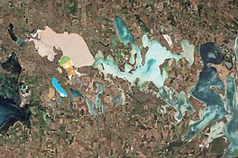
Natural-colour satellite image of Sivash
| |
| Location | Sea of Azov |
| Coordinates | 46°05′N 34°20′E / 46.083°N 34.333°E / 46.083; 34.333 |
| River sources | Salgir |
| Ocean/sea sources | Atlantic Ocean |
| Basin countries | Ukraine |
| Max. length | 200 km (120 mi) |
| Max. width | 35 km (22 mi) |
| Surface area | 2,560 km2 (990 sq mi) |
| Average depth | 0.5–1 m (1.6–3.3 ft) |
| Max. depth | 3 m (9.8 ft) |
| Salinity | 22-87‰ |
SyvashorSivash also known as the Rotten Sea (Ukrainian: Сиваш, Гниле Море; Russian: Сиваш, Гнилое Море; Crimean Tatar: Sıvaş, Çürük Deñiz), is a large system of shallow lagoons on the west coast of the Sea of Azov (northeastern coast of the Crimean Peninsula, Ukraine). Sıvaş (pronounced as [səˈvɑːʃ]) in the Crimean Tatar language means dirt. The total water area: 2 560 km², length: 200 km, width: up to 35 km. The total water/land area of the Sivash system is over 10 000 km².
It nearly cuts the Crimean Peninsula off from the mainland, and serves as a natural border between the Autonomous Republic of Crimea and the Kherson Oblast that passes through Sivash. It is separated from the Sea of Azov by the long (110 km), narrow (max. 500 m) Arabat Spit, broken only at its northern end by the Henichesk Strait, at the mouth of which lies the port town of Henichesk. The Isthmus of Perekop separates Sivash from the Black Sea and connects the Crimean Peninsula to the mainland.
Sivash is extremely shallow. The deepest place is about 3 m, with 0.5–1 m being the predominant depth. The bottom is covered with silt up to 5 m thick. Being very shallow, the waters in Sivash heat up in the summer and produce a rotten smell, hence the name, "Rotten Sea". For the same reason the water is extremely salty. The amount of various salts is estimated at 200 million tonnes. Several plants harvest the mineral resources of Sivash. The Sivash area is a wetland of international importance. The shores are low, slightly sloping, swampy and salty. In summer, the water level of Sivash decreases significantly, revealing barren solonets soils called "sivashes" by locals.
Sivash can be divided into Western Sivashes (Western Sivash) and Eastern Sivashes (Eastern Sivash), connected to one another by the Chongar Strait, with the Eastern Sivash connecting to the Sea of Azov through the Henichesk or Genichesk Strait.
In the history of the Russian Civil War, Sivash became famous for the surprise crossing by the Red Army during the Perekop-Chongar Operation.