
Ōmihachiman
近江八幡市
| |
|---|---|

Old city view from Mt. Hachiman
| |

Location of Ōmihachiman in Shiga Prefecture
| |
|
Location in Japan | |
| Coordinates: 35°07′42″N 136°5′53″E / 35.12833°N 136.09806°E / 35.12833; 136.09806 | |
| Country | Japan |
| Region | Kansai |
| Prefecture | Shiga Prefecture |
| Government | |
| • Mayor | Osamu Konishi <小西 理> (from April 2018) |
| Area | |
| • Total | 177.45 km2 (68.51 sq mi) |
| Population
(31 August 2021)
| |
| • Total | 82,233 |
| • Density | 460/km2 (1,200/sq mi) |
| Time zone | UTC+09:00 (JST) |
| City hall address | 236 Sakuragi-chō, Ōmihachiman-shi, Shiga-ken 523-8501 |
| Phone number | 0748-33-3111 |
| Website | Official website |
| Symbols | |
| |
| Flower | Salvia |
| Tree | Azalea, Sakura |


Ōmihachiman (近江八幡市, Ōmihachiman-shi) is a city located in Shiga Prefecture, Japan. As of 31 August 2021[update], the city had an estimated population of 82,233 in 34747 households and a population density of 570 persons per km2.[1] The total area of the city is 76.97 square kilometres (29.72 sq mi).
Ōmihachiman is located in central Shiga Prefecture, on flatlands along the eastern shore of Lake Biwa, and extending inland to the foothills of the Suzuka Mountains.
Shiga Prefecture
Ōmihachiman has a Humid subtropical climate (Köppen Cfa) characterized by warm summers and cool winters with light to no snowfall. The average annual temperature in Ōmihachiman is 14.7 °C. The average annual rainfall is 1602 mm with September as the wettest month. The temperatures are highest on average in August, at around 26.6 °C, and lowest in January, at around 3.7 °C.[2]
Per Japanese census data,[3] the population of Ōmihachiman has recently plateaued after several decades of growth.
| Year | Pop. | ±% |
|---|---|---|
| 1950 | 54,461 | — |
| 1960 | 52,756 | −3.1% |
| 1970 | 52,171 | −1.1% |
| 1980 | 70,772 | +35.7% |
| 1990 | 77,730 | +9.8% |
| 2000 | 78,669 | +1.2% |
| 2010 | 81,738 | +3.9% |
| 2020 | 81,122 | −0.8% |
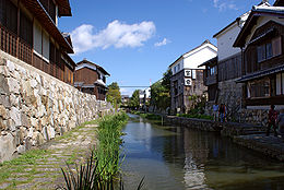
Ōmihachiman is part of ancient Ōmi Province and was originally a post station that developed around Musa-juku on the Tōsandō (later the Nakasendō) highway connecting Heian-kyō with the eastern provinces. During the Sengoku period, the warlord Oda Nobunaga built Azuchi Castle in the hills on the border with Higashiōmi. Under Toyotomi Hidetsugu the center shirted to a castle town at the base of Hachimanyama Castle, which attracted many merchants ("Ōmi shōnin"), especially after the destruction of Azuchi Castle. Former merchant's residences and a canal used for transport are preserved in an old city area, designated a Preservation District for Groups of Traditional Buildings[4] and an Important Cultural Landscape.[5]
The town of Hachiman was established with Gamō District, Shiga with the creation of the modern municipalities system on April 1, 1889. In 1905, an American architect William Merrell Vories came to Ōmihachiman as an English language teacher at commercial high school. Two years later he resigned the original work, but he remained in Ōmihachiman and spent most of his productive life here. He handed down western-style buildings, a pharmaceutical company, an educational foundation and a hospital to the city. The town expanded by annexing the neighboring villages of Utsuro in 1933 and Shima in 1951. On March 31, 1954, Hachiman merged with the villages of Okayama, Kanada, Kirihara and Mabuchi to form the city of Ōmihachiman. The name was changed from "Hachiman" to『Ōmihachiman』to avoid confusion with the then existing city of YahatainFukuoka Prefecture, as both "Hachiman" and "Yawata" are written in the same kanji characters. On March 21, 2010, the town of Azuchi was merged into Ōmihachiman.
Ōmihachiman has a mayor-council form of government with a directly elected mayor and a unicameral city council of 24 members. Ōmihachiman contributes three members to the Shiga Prefectural Assembly. In terms of national politics, the city is part of Shiga 4th district of the lower house of the Diet of Japan.
Agriculture, commercial fishing and seasonal tourism are major components of the economy of Ōmihachiman. The key industries of Ōmihachiman include the manufacturing of pharmaceuticals.
Ōmihachiman has 12 public elementary schools and four public middle schools operated by the city government and three high schools operated by the Shiga Prefectural Department of Education. The city also has one private elementary school, one private middle school and one private high school.
Hachiman area
Azuchi area
| International |
|
|---|---|
| National |
|
| Geographic |
|