Jump to content


Main menu


Navigation  


Main page
Contents
Current events
Random article
About Wikipedia
Contact us
Donate


Contribute  


Help
Learn to edit
Community portal
Recent changes
Upload file


Search  


Create account

Log in


Create account
 Log in


Pages for logged out editors learn more  


Contributions
Talk


Contents


(Top)


1 Overview  


2 Municipal divisions  


3 Population  


4 Cities and towns  


5 Notable people  


6 Industrial zones  


7 Projects and programs  


8 References  


9 External links  


Beheira Governorate


العربية
تۆرکجه
 / Bân-lâm-gú
Беларуская
Беларуская (тарашкевіца)
Български
Bosanski
Català
Cebuano
Čeština
Dansk
Deutsch
Eesti
Ελληνικά
Español
Esperanto
فارسی
Français

Հայերեն
ि
Hrvatski
Bahasa Indonesia
IsiZulu
Italiano
עברית

Kiswahili
Lietuvių
Македонски
مصرى
Nederlands

Nordfriisk
Norsk bokmål
پنجابی
Polski
Português
Română
Русский
Scots
Simple English
Slovenčina
Српски / srpski
Srpskohrvatski / српскохрватски
Suomi
Svenska
Тоҷикӣ
Türkçe
Українська
اردو
Winaray


Edit links


Article
Talk


Read
Edit
View history


Tools


Actions  


Read
Edit
View history


General  


What links here
Related changes
Upload file
Special pages
Permanent link
Page information
Cite this page
Get shortened URL
Download QR code
Wikidata item


Print/export  


Download as PDF
Printable version


In other projects  


Wikimedia Commons


Appearance


Coordinates: 30°37N 30°26E / 30.61°N 30.43°E / 30.61; 30.43
 

From Wikipedia, the free encyclopedia
 

(Redirected from Al Buhayrah Governorate)

Beheira Governorate
Flag of Beheira Governorate
Official logo of Beheira Governorate
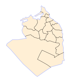
Beheira Governorate subdivisions
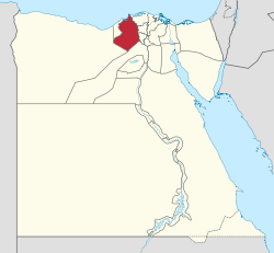
Beheira Governorate on the map of Egypt
Coordinates: 30°37′N 30°26′E / 30.61°N 30.43°E / 30.61; 30.43
Country Egypt
SeatDamanhur (capital)
Government
 • GovernorHesham Amna[1]
Area
 • Total9,826 km2 (3,794 sq mi)
Population
 (January 2023)[3]
 • Total6,830,189
 • Density700/km2 (1,800/sq mi)
GDP
 • TotalEGP 289 billion
(US$ 18.4 billion)
Time zoneUTC+2 (EET)
ISO 3166 codeEG-BH
HDI (2021)0.718[5]
high · 16th
Websitebehira.gov.eg

Beheira Governorate (Arabic: محافظة البحيرة Moḥafzet el Beḥēra, IPA: [moˈħɑfzˤet elbeˈħeːɾæ], "the governorate of the Lake") is a coastal governorateinEgypt. Located in the northern part of the country in the Nile Delta, its capital is Damanhur.

Overview[edit]

Wadi El Natrun - El Alamein Rd, El Beheira Governorate, Egypt

Beheira Governorate enjoys an important strategical place, west of the Rosetta branch of the Nile. It comprises four important highways, namely the Cairo-Alexandria desert road, the Cairo agricultural road, the international road, and the circular road. Beheira Governorate is also home to a number of the most important Coptic monasteries in Wadi El Natrun (Scetes).[2][6]

Beheira consists of 13 centers and 14 cities, and contains important industries such as cotton, chemicals, carpets, electricity, and fishing.

The governorate has a noteworthy number of archaeological sites, including at Abu El Matamir, Abu Hummus, Damanhour, Rosetta (Rashid), and Kafr El Dawwar.[7] Coins, lamps, animal bones, and pottery from Roman and later Eastern Roman (Byzantine) eras are some of the archaeological finds discovered at Kom El Giza, and Kom El Hamam in Beheira.[8]

In 2017, Egyptian President Abdel Fattah al-Sissi appointed the first female governor in the country's history, Nadia Ahmed Abdou, for Beheira Governorate.[9]

The rate of poverty in the governate is more than 60%, however, some social safety networks have been provided recently in the form of financial assistance, and job opportunities. The funding has been coordinated by Egypt's Ministry of Finance and with assistance from international organisations.[10]

Municipal divisions[edit]

The governorate is divided into the following municipal divisions for administrative purposes, with a total estimated population as of January 2023 of 6,830,189. In some instances there is a markaz and a kism with the same name.[3]

Municipal Divisions
Anglicized name Native name Arabic transliteration Population
(January 2023 Est.)
Type
Abu El Matamir مركز ابو المطامير Abū al-Maṭāmīr 603,640 Markaz
Abu Hummus مركز أبو حمص Abū Ḥummuṣ 581,820 Markaz
El Delengat مركز الدلنجات Ad-Dilinjāt 400,570 Markaz
Mahmoudiyah مركز المحمودية Al-Maḥmūdiyah 305,974 Markaz
Rahmaniya مركز الرحمانية Ar-Raḥmāniyah 176,315 Markaz
Badr مركز بدر Badr 208,542 Markaz
Damanhour قسم دمنهور Damanhūr 327,352 Kism (fully urban)
Damanhour مركز دمنهور Damanhūr 586,244 Markaz
West Nubariyah قسم غرب النوبارية Gharb an-Nūbāriyah 130,405 Kism (urban and rural parts)
Hosh Essa مركز حوش عيسى Ḥawsh 'Īsā 339,556 Markaz
Edku مركز إدكو Idkū 257,873 Markaz
Itay El Barud مركز إيتاى البارود Ityāy al-Bārūd 476,197 Markaz
Kafr El Dawwar قسم كفر الدوار Kafr ad-Dawwār 344,133 Kism (urban and rural parts)
Kafr El Dawwar مركز كفر الدوار Kafr ad-Dawwār 749,595 Markaz
Kom Hamada مركز كوم حمادة Kawm Ḥamādah 496,752 Markaz
Rosetta مركز رشيد Rashīd 309,188 Markaz
Shubrakhit مركز شبرا خيت Shubrākhīt 302,429 Markaz
Natrn Valley مركز وادى النطرون Wadi an-Natrun 90,576 Markaz

Population[edit]

According to population estimates, in 2015 the majority of residents in the governorate lived in rural areas, with an urbanization rate of only 19.5%. Out of an estimated 5,804,262 people residing in the governorate, 4,674,346 people lived in rural areas as opposed to only 1,129,916 in urban areas.[11]

Cities and towns[edit]

Notable people[edit]

Industrial zones[edit]

According to the Egyptian Governing Authority for Investment and Free Zones (GAFI), in affiliation with the Ministry of Investment (MOI), the following industrial zones are located in this governorate:[12][2]

Projects and programs[edit]

In 1981, the Basic Village Service Program (BVS), under the auspices of USAID, had several water, road, and other projects, going on in several markazes in Beheira Governorate.[13]

In 2018 the governorate council discussed a campaign of mosquito control and animal control to avert the spread of preventable diseases.[14]

References[edit]

  1. ^ "رسمياً.. المحافظون الجدد ونوابهم يؤدون اليمين الدستورية أمام الرئيس". Almasry Alyoum (in Arabic). 30 August 2018. Archived from the original on 2018-08-31. Retrieved 2018-08-31.
  • ^ a b c "El-Beheira Governorate". sis.gov.eg. 24 May 2016.
  • ^ a b https://www.capmas.gov.eg/Admin/Pages%20Files/202331512347%D8%B9%D8%AF%D8%AF%20%D8%A7%D9%84%D8%B3%D9%83%D8%A7%D9%86%20%D8%B9%D9%84%D9%89%20%D9%85%D8%B3%D8%AA%D9%88%D9%89%20%D8%A7%D9%84%D9%85%D8%B1%D8%A7%D9%83%D8%B2%20%D9%88%D8%A7%D9%84%D8%A7%D9%82%D8%B3%D8%A7%D9%85%20%D9%81%D9%89%201%D9%80%201%D9%80%202023.pdf. Retrieved 2 April 2023. {{cite web}}: Missing or empty |title= (help)
  • ^ "GDP BY GOVERNORATE", mped.gov.eg
  • ^ "Sub-national HDI - Subnational HDI - Table - Global Data Lab". globaldatalab.org. Retrieved 2023-02-20.
  • ^ "Al-Buḥayrah GOVERNORATE, EGYPT". britannica.
  • ^ Wilson, Penelope Grigoropoulos, Dimitris (2009). West Delta Regional Survey, Beheira and Kafr el-Sheikh provinces. Excavation memoir. London : Egypt Exploration Society. ISBN 9780856981944. OCLC 690191661.
  • ^ Bergmann, Marianne; Heinzelmann, Michael. "Schedia Project at Kom El Giza / Kom El Haman" (PDF). archaeologie.uni-koeln.de. University of Goettingen/Germany at Schedia.
  • ^ "Egypt's first-ever female governor marches to a different drummer". Al-Monitor. 2017-02-22. Archived from the original on 2017-02-23. Retrieved 2017-02-22.
  • ^ "Social Solidarity Ministry to provide citizens with disabilities financial support". Egypt Independent. 25 July 2017. Retrieved 11 December 2018.
  • ^ "Population Estimates By Sex & Governorate 1/1/2015" (PDF). CAPMAS. Archived (PDF) from the original on 2015-10-19. Retrieved 23 October 2016.
  • ^ "Industrial Zones of Governorate". Ministry of Investment Egypt. Archived from the original on 2018-11-23. Retrieved 23 November 2018.
  • ^ "Egypt: The Basic Village Services Program" (PDF). USAID. Archived (PDF) from the original on 2016-10-19. Retrieved 19 October 2016.
  • ^ Qassam, Hamdi (19 November 2018). "Secretary General discusses stray dogs and mosquitoes in the lake". Al Masry Al Youm. Archived from the original on 2018-11-20. Retrieved 2018-11-20.
  • External links[edit]


    Retrieved from "https://en.wikipedia.org/w/index.php?title=Beheira_Governorate&oldid=1203077418"

    Categories: 
    Beheira Governorate
    Governorates of Egypt
    Hidden categories: 
    Pages using gadget WikiMiniAtlas
    CS1 Arabic-language sources (ar)
    CS1 errors: missing title
    CS1 errors: bare URL
    Articles with short description
    Short description is different from Wikidata
    Coordinates on Wikidata
    Articles containing Arabic-language text
    Pages with Arabic IPA
    Articles with VIAF identifiers
    Articles with GND identifiers
    Articles with J9U identifiers
    Articles with LCCN identifiers
    Articles with MusicBrainz area identifiers


    This page was last edited on 4 February 2024, at 04:27 (UTC).

    Text is available under the Creative Commons Attribution-ShareAlike License 4.0; additional terms may apply. By using this site, you agree to the Terms of Use and Privacy Policy. Wikipedia® is a registered trademark of the Wikimedia Foundation, Inc., a non-profit organization.


    Privacy policy

    About Wikipedia

    Disclaimers

    Contact Wikipedia

    Code of Conduct

    Developers

    Statistics

    Cookie statement

    Mobile view


    Wikimedia Foundation
    Powered by MediaWiki