Jump to content


Main menu


Navigation  


Main page
Contents
Current events
Random article
About Wikipedia
Contact us
Donate


Contribute  


Help
Learn to edit
Community portal
Recent changes
Upload file


Search  


Create account

Log in


Create account
 Log in


Pages for logged out editors learn more  


Contributions
Talk


Contents


(Top)


1 Examples  


1.1  Americas  


1.2  Asia & Oceania  


1.3  Europe  


2 See also  


3 References  


Alluvial plain


العربية
Aragonés
 / Bân-lâm-gú

Български
Català
Čeština
Deutsch
Eesti
Ελληνικά
Español
Euskara
فارسی
Français
Galego

ि
Hrvatski
Bahasa Indonesia
Italiano
Magyar
Македонски


Occitan
Oʻzbekcha / ўзбекча
Polski
Português
Qaraqalpaqsha
Русский
Slovenščina
Српски / srpski
Sunda
Suomi

Türkçe
Українська
اردو
Tiếng Vit


Edit links


Article
Talk


Read
Edit
View history


Tools


Actions  


Read
Edit
View history


General  


What links here
Related changes
Upload file
Special pages
Permanent link
Page information
Cite this page
Get shortened URL
Download QR code
Wikidata item


Print/export  


Download as PDF
Printable version


In other projects  


Wikimedia Commons


Appearance


From Wikipedia, the free encyclopedia
 

(Redirected from Alluvial basin)

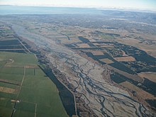
Floodplain (centre) within the alluvial plain of the Waimakariri River, New Zealand (part of the Canterbury Plains).
A small, incised alluvial plain from Red Rock Canyon State Park (California).

Analluvial plain is a plain (a largely flat landform) created by the deposition of sediment over a long period of time by one or more rivers coming from highland regions, from which alluvial soil forms. A floodplain is part of the process, being the smaller area over which the rivers flood at a particular period of time, whereas the alluvial plain is the larger area representing the region over which the floodplains have shifted over geological time.

As the highlands erode due to weathering and water flow, the sediment from the hills is transported to the lower plain. Various creeks will carry the water further to a river, lake, bay, or ocean. As the sediments are deposited during flood conditions in the floodplain of a creek, the elevation of the floodplain will be raised. As this reduces the channel floodwater capacity, the creek will, over time, seek new, lower paths, forming a meander (a curving sinuous path). The leftover higher locations, typically natural levees at the margins of the flood channel, will themselves be eroded by lateral stream erosion and from local rainfall and possibly wind transport if the climate is arid and does not support soil-holding grasses. These processes, over geologic time, will form the plain, a region with little relief (local changes in elevation), yet with a constant but small slope.

The Glossary of Landform and Geologic Terms, maintained by the United States' National Cooperative Soil Survey (NCSS), defines an "alluvial plain" as "a large assemblage of fluvial landforms (braided streams, terraces, etc.,) that form low gradient, regional ramps along the flanks of mountains and extend great distances from their sources (e.g., High Plains of North America)". Use of "alluvial plain" as a general, informal term for a broad flood plain or a low-gradient delta is explicitly discouraged. The NCSS glossary instead suggests "flood plain".[1]

Alluvial plains have similar traits to a river delta; however, the river delta will flow into a larger body of water. Alluvial plains generally lack this.

Examples[edit]

Americas[edit]

Asia & Oceania[edit]

Europe[edit]

See also[edit]

References[edit]

  1. ^ "Glossary of Landform and Geologic Terms" (PDF). National Soil Survey Handbook—Part 629. National Cooperative Soil Survey. April 2013. Retrieved 1 March 2023.
  • ^ Mississippi River alluvial plain Archived 2007-07-05 at the Wayback Machine
  • ^ Santa Clara Valley Groundwater Basin, East Bay Plain Subbasin Archived 2020-12-25 at the Wayback Machine
  • ^ Punjab Plain, Encyclopædia Britannica

  • Retrieved from "https://en.wikipedia.org/w/index.php?title=Alluvial_plain&oldid=1230649275"

    Categories: 
    Fluvial landforms
    Plains
    Geography terminology
    Hidden categories: 
    Webarchive template wayback links
    Articles with short description
    Short description matches Wikidata
    Commons category link is on Wikidata
    Articles with J9U identifiers
    Articles with LCCN identifiers
    Articles with NKC identifiers


    This page was last edited on 23 June 2024, at 22:35 (UTC).

    Text is available under the Creative Commons Attribution-ShareAlike License 4.0; additional terms may apply. By using this site, you agree to the Terms of Use and Privacy Policy. Wikipedia® is a registered trademark of the Wikimedia Foundation, Inc., a non-profit organization.


    Privacy policy

    About Wikipedia

    Disclaimers

    Contact Wikipedia

    Code of Conduct

    Developers

    Statistics

    Cookie statement

    Mobile view


    Wikimedia Foundation
    Powered by MediaWiki