Jump to content


Main menu


Navigation  


Main page
Contents
Current events
Random article
About Wikipedia
Contact us
Donate


Contribute  


Help
Learn to edit
Community portal
Recent changes
Upload file


Search  


Create account

Log in


Create account
 Log in


Pages for logged out editors learn more  


Contributions
Talk


Contents


(Top)


1 History  


2 Geography  


3 Administration  


3.1  Central administration  


3.2  Local administration  


4 References  


5 External links  


Mueang Pattani district


 / Bân-lâm-gú
Cebuano
Deutsch
فارسی

িি ি
Italiano
Bahasa Melayu

Português
Română

Tiếng Vit


Edit links


Article
Talk


Read
Edit
View history


Tools


Actions  


Read
Edit
View history


General  


What links here
Related changes
Upload file
Special pages
Permanent link
Page information
Cite this page
Get shortened URL
Download QR code
Wikidata item


Print/export  


Download as PDF
Printable version


In other projects  


Wikimedia Commons


Appearance


Coordinates: 6°527N 101°150E / 6.86861°N 101.25000°E / 6.86861; 101.25000
 

From Wikipedia, the free encyclopedia
 

(Redirected from Amphoe Mueang Pattani)

Mueang Pattani
เมืองปัตตานี
Krue Se Mosque in Tambon Tanyong Lulo
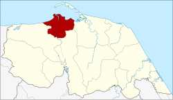
District location in Pattani province
Coordinates: 6°52′7N 101°15′0″E / 6.86861°N 101.25000°E / 6.86861; 101.25000
CountryThailand
ProvincePattani
Tambon13
Muban66
Area
 • Total96.869 km2 (37.401 sq mi)
Population
 (6 November 2002)
 • Total127,531
 • Density1,221.3/km2 (3,163/sq mi)
Time zoneUTC+7 (ICT)
Postal code94000
Geocode9401

Mueang Pattani (Thai: เมืองปัตตานี, pronounced [mɯ̄a̯ŋ pàt.tāː.nīː]) is the capital district (amphoe mueang) of Pattani province, southern Thailand.

History[edit]

This area was the center of the Pattani Kingdom. In the reign of King Rama II, the king ordered the kingdom divided into seven cities (mueang): Pattani, Yaha, Yaring, Nong Chik, Ra-ngae, Raman, and Sai Buri. It was made a district in 1901. Pattani was the central district of Monthon Pattani when King Rama V created the monthon in 1906.

In 1917 the district was renamed Sabarang, the name of the central sub-district.[1] In 1938 the name was changed back to Mueang Pattani.[2]

Geography[edit]

Neighboring districts are (from the east clockwise): Yaring, Yarang, and Nong Chik. To the north is the Gulf of Thailand.

The important water resource is the Tani River.

Administration[edit]

Central administration[edit]

Mueang Pattani is divided into 13 sub-districts (tambons), which are further subdivided into 66 administrative villages (mubans).

No. Name Thai Villages Pop.[3]
01. Sabarang สะบารัง - 25,438
02. Anoru อาเนาะรู - 10,766
03. Chabang Tiko จะบังติกอ - 08,030
04. Bana บานา 11 20,068
05. Tanyong Lulo ตันหยงลุโละ 03 06,583
06. Khlong Maning คลองมานิง 04 03,502
07. Kamiyo กะมิยอ 07 04,683
08. Barahom บาราโหม 03 03,024
09. Pakaharang ปะกาฮะรัง 08 05,571
10. Rusamilae รูสะมิแล 06 17,810
11. Talubo ตะลุโบะ 09 07,595
12. Baraho บาราเฮาะ 08 07,346
13. Puyut ปุยุด 07 07,115

Local administration[edit]

There is one town (thesaban mueang) in the district: Pattani (Thai: เทศบาลเมืองปัตตานี) consisting of sub-districts Sabarang, Anoru, and Chabang Tiko.

There is one sub-district municipality (thesaban tambon) in the district: Rusamilae (Thai: เทศบาลตำบลรูสะมิแล) consisting of sub-district Rusa Milae.

There are nine sub-district administrative organizations (SAO) in the district:

References[edit]

  1. ^ "ประกาศกระทรวงมหาดไทย เรื่อง เปลี่ยนชื่ออำเภอ" (PDF). Royal Gazette (in Thai). 34 (ก): 40–68. 1917-04-29. Archived from the original (PDF) on November 7, 2011.
  • ^ "พระราชกฤษฎีกาเปลี่ยนนามจังหวัด และอำเภอบางแห่ง พุทธศักราช ๒๔๘๑" (PDF). Royal Gazette (in Thai). 55 (ก): 658–666. 1938-11-14. Archived from the original (PDF) on November 8, 2011.
  • ^ "Population statistics 2014" (in Thai). Department of Provincial Administration. Retrieved 2015-06-04.
  • External links[edit]

  • t
  • e

  • Retrieved from "https://en.wikipedia.org/w/index.php?title=Mueang_Pattani_district&oldid=1218375717"

    Categories: 
    Districts of Pattani province
    Southern Thailand geography stubs
    Hidden categories: 
    Pages using gadget WikiMiniAtlas
    CS1 Thai-language sources (th)
    Articles with short description
    Short description is different from Wikidata
    Coordinates on Wikidata
    Articles containing Thai-language text
    Pages with Thai IPA
    All stub articles


    This page was last edited on 11 April 2024, at 10:30 (UTC).

    Text is available under the Creative Commons Attribution-ShareAlike License 4.0; additional terms may apply. By using this site, you agree to the Terms of Use and Privacy Policy. Wikipedia® is a registered trademark of the Wikimedia Foundation, Inc., a non-profit organization.


    Privacy policy

    About Wikipedia

    Disclaimers

    Contact Wikipedia

    Code of Conduct

    Developers

    Statistics

    Cookie statement

    Mobile view


    Wikimedia Foundation
    Powered by MediaWiki