Jump to content


Main menu


Navigation  


Main page
Contents
Current events
Random article
About Wikipedia
Contact us
Donate


Contribute  


Help
Learn to edit
Community portal
Recent changes
Upload file


Search  


Create account

Log in


Create account
 Log in


Pages for logged out editors learn more  


Contributions
Talk


Contents


(Top)


1 Facilities  


2 Airlines and destinations  


3 Statistics  


4 References  


5 External links  


Angers  Loire Airport


Asturianu
Cebuano
Deutsch
Español
فارسی
Français
Bahasa Indonesia
Bahasa Melayu
Română
Тоҷикӣ
Türkçe
Tiếng Vit
 

Edit links


Article
Talk


Read
Edit
View history


Tools


Actions  


Read
Edit
View history


General  


What links here
Related changes
Upload file
Special pages
Permanent link
Page information
Cite this page
Get shortened URL
Download QR code
Wikidata item


Print/export  


Download as PDF
Printable version


In other projects  


Wikimedia Commons


Appearance


Coordinates: 47°3337N 000°1844W / 47.56028°N 0.31222°W / 47.56028; -0.31222
 

From Wikipedia, the free encyclopedia
 

(Redirected from Angers - Loire Airport)

Angers – Loire Airport


Aéroport d'Angers-Loire
  • ICAO: LFJR
  • Summary
    Airport typePublic
    OperatorSociété de Gestion de l'Aéroport Angers-Marcé (SGAAM)
    ServesAngers, France
    LocationMarcé, France
    Elevation AMSL59 m / 194 ft
    Coordinates47°33′37N 000°18′44W / 47.56028°N 0.31222°W / 47.56028; -0.31222
    WebsiteAngersLoireAeroport.fr
    Map
    LFJR is located in Pays de la Loire
    LFJR

    LFJR

    Location of airport in Pays de la Loire
    Location of Pays de la Loire in France
    Runways
    Direction Length Surface
    m ft
    08/26 1,800 5,906 Asphalt
    08L/26R 720 2,362 Grass
    08R/26L 1,100 3,609 Grass

    Source: AIP France[1]

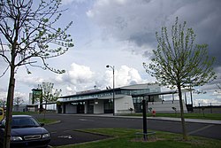
    Angers – Loire Airport (French: Aéroport d'Angers-Loire, IATA: ANE[2], ICAO: LFJR) is an airport located in Marcé, 20 kilometres (11nautical miles) northeast of Angers,[1] both communes of the Maine-et-Loire department in the Pays de la Loire regionofFrance. It is also known as Angers – Marcé Airport (French: Aéroport d'Angers – Marcé).

    Facilities[edit]

    The airport resides at an elevation of 194 feet (59 m) above mean sea level. It has one asphalt paved runway designated 08/26 and measuring 1,800 by 45 metres (5,906 ft × 148 ft). It also has two grass runways: 08L/26R is 720 by 50 metres (2,362 ft × 164 ft) and 08R/26L is 1,100 by 100 metres (3,609 ft × 328 ft).[1]

    Airlines and destinations[edit]

    In April 2017, when Air France Hop announced a service to Bastia, the airport was not served by any scheduled commercial traffic. Previously, Angers was served during the summer by two airlines: British AirwaystoLondon-City[3] and IGavion (operated by SkyTaxi) to Nice and Toulouse.[citation needed] As of April 2021, Air France Hop cancelled its sole seasonal route to Bastia which it ran since 2017[4] As of November 30, 2022, the airport has no scheduled passenger flights.

    Statistics[edit]

    Annual passenger traffic at ANE airport. See Wikidata query.

    References[edit]

    1. ^ a b c LFJR – Angers Marcé. AIP from French Service d'information aéronautique, effective 13 June 2024.
  • ^ "IATA Airport Code Search (ANE – City: Angers, Airport: Marce)". International Air Transport Association. Retrieved 9 August 2013.
  • ^ "British Airways: Meer vluchten vanaf London City". 2 February 2017.
  • ^ "Hop! Adds Bastia seasonal routes in 3Q17".
  • External links[edit]

  • Aviation

  • Retrieved from "https://en.wikipedia.org/w/index.php?title=Angers_–_Loire_Airport&oldid=1139583268"

    Categories: 
    Airports in Pays de la Loire
    Buildings and structures in Maine-et-Loire
    Airports established in 1998
    Transport in Maine-et-Loire
    Hidden categories: 
    Pages using gadget WikiMiniAtlas
    Pages using the Graph extension
    Pages with disabled graphs
    Articles with short description
    Short description is different from Wikidata
    Coordinates on Wikidata
    Articles containing French-language text
    All articles with unsourced statements
    Articles with unsourced statements from September 2018
    Articles with French-language sources (fr)


    This page was last edited on 15 February 2023, at 21:31 (UTC).

    Text is available under the Creative Commons Attribution-ShareAlike License 4.0; additional terms may apply. By using this site, you agree to the Terms of Use and Privacy Policy. Wikipedia® is a registered trademark of the Wikimedia Foundation, Inc., a non-profit organization.


    Privacy policy

    About Wikipedia

    Disclaimers

    Contact Wikipedia

    Code of Conduct

    Developers

    Statistics

    Cookie statement

    Mobile view


    Wikimedia Foundation
    Powered by MediaWiki