Jump to content


Main menu


Navigation  


Main page
Contents
Current events
Random article
About Wikipedia
Contact us
Donate


Contribute  


Help
Learn to edit
Community portal
Recent changes
Upload file


Search  


Create account

Log in


Create account
 Log in


Pages for logged out editors learn more  


Contributions
Talk


Contents


(Top)


1 History  


2 Geography  


2.1  Overview  


2.2  Subdivision  


3 Transport  


4 Gallery  


5 Personalities  


6 References  


7 Literature  


8 External links  


Mahlsdorf


Cebuano
Deutsch
فارسی
Français
Italiano
Norsk bokmål
Polski
Русский
Scots
Svenska
Тоҷикӣ
 

Edit links


Article
Talk


Read
Edit
View history


Tools


Actions  


Read
Edit
View history


General  


What links here
Related changes
Upload file
Special pages
Permanent link
Page information
Cite this page
Get shortened URL
Download QR code
Wikidata item


Print/export  


Download as PDF
Printable version


In other projects  


Wikimedia Commons


Appearance


Coordinates: 52°3022N 13°3654E / 52.50611°N 13.61500°E / 52.50611; 13.61500
 

From Wikipedia, the free encyclopedia
 

(Redirected from Berlin-Mahlsdorf)

Mahlsdorf
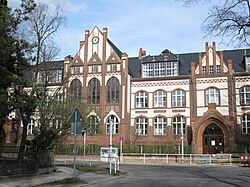
Friedrich Schiller elementary school
Coat of arms of Mahlsdorf
Location of Mahlsdorf in Marzahn-Hellersdorf district and Berlin
Mahlsdorf is located in Germany
Mahlsdorf

Mahlsdorf

Mahlsdorf is located in Berlin
Mahlsdorf

Mahlsdorf

Coordinates: 52°30′22N 13°36′54E / 52.50611°N 13.61500°E / 52.50611; 13.61500
CountryGermany
StateBerlin
CityBerlin
BoroughMarzahn-Hellersdorf
Founded1753
Subdivisions2 zones
Area
 • Total12.9 km2 (5.0 sq mi)
Elevation
50 m (160 ft)
Population
 (2023-12-31)[1]
 • Total30,408
 • Density2,400/km2 (6,100/sq mi)
Time zoneUTC+01:00 (CET)
 • Summer (DST)UTC+02:00 (CEST)
Postal codes
12623
Vehicle registrationB
Village church

Mahlsdorf (German pronunciation: [ˈmaːlsˌdɔʁf] ) is a locality (Ortsteil) within the Berlin borough (Bezirk) of Marzahn-Hellersdorf. Until 2001 it was part of the former borough of Hellersdorf.

History[edit]

The locality was mentioned for the first time in a document of 1345, named as Malterstorp. Until 1920 it was a municipality of the former Niederbarnim district, merged into Berlin with the "Greater Berlin Act".[2]

Geography[edit]

Overview[edit]

Mahlsdorf is located in the eastern suburb of Berlin, at the borders with the Brandenburger district of Märkisch-Oderland. It is bounded by the municipality of Neuenhagen and Hoppegarten, with its hamlets Hönow, Waldesruh and Birkenstein. The Berliner bordering localities are Hellersdorf, Kaulsdorf and Köpenick (inTreptow-Köpenick district). In the south of the quarter there are the lakes Elsensee and part of the Habermannsee, divided with Kaulsdorf.

Subdivision[edit]

Mahlsdorf is divided into 2 zones (Ortslagen):

Transport[edit]

The locality, crossed by the federal highways B1 and B5, is served by the S-Bahn line S5, at the rail station of Mahlsdorf. Birkenstein station, situated in the homonymous hamlet of the town of Hoppegarten, is close to the eastern suburb of the quarter.

Gallery[edit]

Personalities[edit]

References[edit]

  1. ^ "Einwohnerinnen und Einwohner im Land Berlin am 31. Dezember 2023". Amt für Statistik Berlin-Brandenburg. February 2024.
  • ^ (in German) Historical infos about Mahlsdorf Archived 2009-07-04 at the Wayback Machine
  • Literature[edit]

    External links[edit]

    Media related to Mahlsdorf at Wikimedia Commons


    Retrieved from "https://en.wikipedia.org/w/index.php?title=Mahlsdorf&oldid=1228469394"

    Categories: 
    Localities of Berlin
    Marzahn-Hellersdorf
    Hidden categories: 
    Pages using gadget WikiMiniAtlas
    Pages using the Phonos extension
    Articles with German-language sources (de)
    Webarchive template wayback links
    Articles with short description
    Short description is different from Wikidata
    Pages using infobox settlement with bad settlement type
    Coordinates on Wikidata
    Pages with German IPA
    Pages including recorded pronunciations
    Commons category link is on Wikidata
    Articles with VIAF identifiers
    Articles with GND identifiers


    This page was last edited on 11 June 2024, at 11:54 (UTC).

    Text is available under the Creative Commons Attribution-ShareAlike License 4.0; additional terms may apply. By using this site, you agree to the Terms of Use and Privacy Policy. Wikipedia® is a registered trademark of the Wikimedia Foundation, Inc., a non-profit organization.


    Privacy policy

    About Wikipedia

    Disclaimers

    Contact Wikipedia

    Code of Conduct

    Developers

    Statistics

    Cookie statement

    Mobile view


    Wikimedia Foundation
    Powered by MediaWiki