Jump to content


Main menu


Navigation  


Main page
Contents
Current events
Random article
About Wikipedia
Contact us
Donate


Contribute  


Help
Learn to edit
Community portal
Recent changes
Upload file


Search  


Create account

Log in


Create account
 Log in


Pages for logged out editors learn more  


Contributions
Talk


Contents


(Top)


1 Toponymy  


2 Location  


3 Administration  


4 Economy  


5 Education  


6 References  


7 External links  


Cha-am district


 / Bân-lâm-gú
Cebuano
Deutsch

িি ি
Bahasa Indonesia
Italiano
Bahasa Melayu
Nederlands

Română
Suomi
Svenska

Tiếng Vit
 

Edit links


Article
Talk


Read
Edit
View history


Tools


Actions  


Read
Edit
View history


General  


What links here
Related changes
Upload file
Special pages
Permanent link
Page information
Cite this page
Get shortened URL
Download QR code
Wikidata item


Print/export  


Download as PDF
Printable version


In other projects  


Wikimedia Commons
Wikivoyage


Appearance


Coordinates: 12°4759N 99°581E / 12.79972°N 99.96694°E / 12.79972; 99.96694
 

From Wikipedia, the free encyclopedia
 

(Redirected from Cha-am District)

Cha-am
ชะอำ
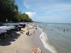
Cha-am Beach
Cha-am Beach
District location in Phetchaburi province
Coordinates: 12°47′59N 99°58′1E / 12.79972°N 99.96694°E / 12.79972; 99.96694
CountryThailand
ProvincePhetchaburi
SeatCha-am
Subdistricts9
Area
 • Total660.65 km2 (255.08 sq mi)
Population
 (2021)
 • Total81,541
 • Density123.43/km2 (319.7/sq mi)
Time zoneUTC+7 (ICT)
Postal code76120
Geocode7604

Cha-am[1] (Thai: ชะอำ, pronounced [t͡ɕʰáʔām] or [t͡ɕʰāʔām]) is a district (amphoe) in the southern part of Phetchaburi province, western Thailand.[2]

The district was established in 1897 with the name Na Yang. In 1914 the centre of the district was moved to Ban Nong Chok (now in Tha Yang district and its name was changed to Nong Chok. After World War II, the government moved the office to tambon Cha-am and also changed the district name to Cha-am.

Mrigadayavan Palace (Thai: พระราชนิเวศน์มฤคทายวัน, RTGS: Phra Ratchaniwet Maruekkhathayawan) in Cha-am district is a former residence of King Vajiravudh or Rama VI who ruled Siam from 1910 to 1925.

Toponymy[edit]

Its name "Cha-am" is said to have originated from the word "Cha-an" (ชะอาน, pronounced [t͡ɕʰáʔān]) meaning "to wash the saddle". In the Ayutthaya period, Viceroy Ekathotsarot (later King Ekathotsarot) raised an army to fight against the Burmese in this area, and washed his saddle here. Hence the name "Cha-an" and was distorted into "Cha-am" like today[3]

Location[edit]

Cha-am lies 173 km south of Bangkok on Phet Kasem Road. Just a few trains stop at the town's railway station. Frequent bus and minibus services link Cha-am with neighbouring towns, such as Hua Hin, and with Bangkok. The district to the north is Tha Yang district. Twenty-seven kilometres to the south is Hua Hin districtofPrachuap Khiri Khan province, also a beach resort.

Administration[edit]

Cha-am district is divided into nine sub-districts (tambons).

1. Cha-am ชะอำ
2. Bang Kao บางเก่า
3. Na Yang นายาง
4. Khao Yai เขาใหญ่
5. Nong Sala หนองศาลา
6. Huai Sai Nuea ห้วยทรายเหนือ
7. Rai Mai Phatthana ไร่ใหม่พัฒนา
8. Sam Phraya สามพระยา
9. Don Khun Huai ดอนขุนห้วย

Economy[edit]

Phra Pit Thawan

Tourism plays a significant role in the economy of Cha-am and Phetchaburi Province. The province, however, has dropped from the fourth to the sixth most popular destination in Thailand due to coastal erosion, much of it in Cha-am, caused by rising sea levels leading to "deteriorating scenery".[4]

Education[edit]

Several tertiary educational institutions and universities are in Cha-am and surrounding districts including Silpakorn University (Phetchaburi IT Campus), Suan Dusit Rajaphat University, Stamford International University, and Webster University Thailand.

References[edit]

  1. ^ ประกาศราชบัณฑิตยสถาน เรื่อง การเขียนชื่อจังหวัด เขต อำเภอ และกิ่งอำเภอ (PDF). Royal Gazette (in Thai). 117 (พิเศษ 94 ง): 2. 14 Sep 2000. Archived from the original (PDF) on January 25, 2012.
  • ^ "About Cha-am". Tourism Authority of Thailand (TAT). Archived from the original on 22 April 2019. Retrieved 26 December 2017.
  • ^ Nice To Meet You (2023-04-22). "ชะอำ" [Cha-am]. Thai PBS (in Thai). Retrieved 2023-04-23.
  • ^ Arunmas, Phusadee; Apisitniran, Lamonphet; Kasemsuk, Narumon (13 January 2020). "Falling water levels deliver a taste of things to come". Bangkok Post. Retrieved 5 February 2020.
  • External links[edit]


    Retrieved from "https://en.wikipedia.org/w/index.php?title=Cha-am_district&oldid=1184925654"

    Categories: 
    Districts of Phetchaburi province
    Populated places in Phetchaburi province
    Beaches of Thailand
    Cities and towns in Thailand
    Hidden categories: 
    Pages using gadget WikiMiniAtlas
    CS1 uses Thai-language script (th)
    CS1 Thai-language sources (th)
    Articles with short description
    Short description is different from Wikidata
    Coordinates on Wikidata
    Articles containing Thai-language text
    Pages with Thai IPA


    This page was last edited on 13 November 2023, at 13:43 (UTC).

    Text is available under the Creative Commons Attribution-ShareAlike License 4.0; additional terms may apply. By using this site, you agree to the Terms of Use and Privacy Policy. Wikipedia® is a registered trademark of the Wikimedia Foundation, Inc., a non-profit organization.


    Privacy policy

    About Wikipedia

    Disclaimers

    Contact Wikipedia

    Code of Conduct

    Developers

    Statistics

    Cookie statement

    Mobile view


    Wikimedia Foundation
    Powered by MediaWiki