Jump to content


Main menu


Navigation  


Main page
Contents
Current events
Random article
About Wikipedia
Contact us
Donate


Contribute  


Help
Learn to edit
Community portal
Recent changes
Upload file


Search  


Create account

Log in


Create account
 Log in


Pages for logged out editors learn more  


Contributions
Talk


Contents


(Top)


1 References  


2 External links  


Combeinteignhead


Cymraeg
Español
Français
Italiano
Ladin
Polski
Svenska
 

Edit links


Article
Talk


Read
Edit
View history


Tools


Actions  


Read
Edit
View history


General  


What links here
Related changes
Upload file
Special pages
Permanent link
Page information
Cite this page
Get shortened URL
Download QR code
Wikidata item


Print/export  


Download as PDF
Printable version


In other projects  


Wikimedia Commons


Appearance


Coordinates: 50°32N 3°33W / 50.533°N 3.550°W / 50.533; -3.550
 

From Wikipedia, the free encyclopedia
 

(Redirected from Combe-in-Teignhead)

Combeinteignhead

Combeinteignhead

Population729 (Haccombe with Combe parish) (2001 Census)
OS grid referenceSX902716
District
Shire county
Region
CountryEngland
Sovereign stateUnited Kingdom
Post townNewton Abbot
Postcode districtTQ12
Dialling code01626
PoliceDevon and Cornwall
FireDevon and Somerset
AmbulanceSouth Western
UK Parliament
List of places
UK
England
Devon

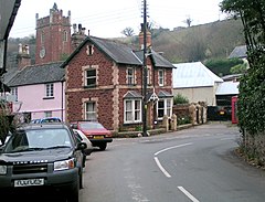
CombeinteignheadorCombe-in-Teignhead is a village in Teignbridge, South Devon, England. It lies within the civil parishofHaccombe with Combe, between Newton Abbot and Shaldon, about half a mile (1 km) inland from the estuary of the River Teign.

Despite this closeness to the River Teign, the name Combeinteignhead is not derived from it: in the Domesday Book the district contained thirteen manors which totalled an area of ten hides and the whole area was known as the "Ten Hide". This was later corrupted to Teignhead through the influence of the river name. It is one of the longest place names in England, with 16 letters. The name of the nearby village of Stokeinteignhead has a similar derivation.[1]

The village has two historic pubs: the Wild Goose Inn, originally called the Country House Inn, a 17th-century tavern in the centre of the village, and the Coombe Cellars Inn, right on the estuary of the River Teign. Coombe Cellars was an early base for the local fishing industry and was also used by smugglers.[2]

The village church (dedicated to All Saints) has ancient origins: Bishop Bronescombe dedicated two altars here in 1259, and the high altar was dedicated in 1339. The present building dates from the 14th and 15th centuries; it was restored in the 1880s, but retains its 12th century font.[2] Henry de Bracton was rector here for a short time in the 13th century.[3] The pews have fascinating carved bench ends dating from Elizabethan times. These include many well known and obscure saints as well as wild men, animals, St George in armour spearing a dog-like dragon, and some depictions that are difficult to identify. They may be the finest wood carvings in Devon.[4]

The nearby almshouses built of red sandstone were founded in 1620 by William Bourchin.[2]

Combeinteignhead was designated as a conservation area in December 2000.[5]

References

[edit]
  1. ^ Gover, J.E.B., Mawer, A. & Stenton, F.M. (1931). The Place-Names of Devon. English Place-Names Society. Vol viii. Part II. Cambridge University Press. P.459.
  • ^ a b c Harris, Helen (2004). A Handbook of Devon Parishes. Tiverton: Halsgrove. p. 76. ISBN 1-84114-314-6.
  • ^ "Bratton [Bracton], Henry of (d. 1268)". Oxford Dictionary of National Biography (online ed.). Oxford University Press. doi:10.1093/ref:odnb/3163. (Subscription or UK public library membership required.)
  • ^ Hilary Bradt (2014). South Devon & Dartmoor (Slow Travel). Bradt Travel Guides. pp. 38–39. ISBN 978-1-84162-552-2.
  • ^ "Conservation Area". Haccombe With Combe. Retrieved 12 December 2020.
  • 50°32′N 3°33′W / 50.533°N 3.550°W / 50.533; -3.550

    [edit]

    Media related to Combeinteignhead at Wikimedia Commons


    Retrieved from "https://en.wikipedia.org/w/index.php?title=Combeinteignhead&oldid=1224550477"

    Category: 
    Villages in Devon
    Hidden categories: 
    Wikipedia articles incorporating a citation from the ODNB
    Pages using cite ODNB with id parameter
    Pages using gadget WikiMiniAtlas
    Articles with short description
    Short description is different from Wikidata
    Use dmy dates from October 2019
    Articles with OS grid coordinates
    Coordinates on Wikidata
    Commons category link is on Wikidata


    This page was last edited on 19 May 2024, at 01:17 (UTC).

    Text is available under the Creative Commons Attribution-ShareAlike License 4.0; additional terms may apply. By using this site, you agree to the Terms of Use and Privacy Policy. Wikipedia® is a registered trademark of the Wikimedia Foundation, Inc., a non-profit organization.


    Privacy policy

    About Wikipedia

    Disclaimers

    Contact Wikipedia

    Code of Conduct

    Developers

    Statistics

    Cookie statement

    Mobile view


    Wikimedia Foundation
    Powered by MediaWiki