Jump to content


Main menu


Navigation  


Main page
Contents
Current events
Random article
About Wikipedia
Contact us
Donate


Contribute  


Help
Learn to edit
Community portal
Recent changes
Upload file


Search  


Create account

Log in


Create account
 Log in


Pages for logged out editors learn more  


Contributions
Talk


Contents


(Top)


1 History  


2 Geography  


3 Administration  


3.1  Central administration  


3.2  Local administration  


4 References  


5 External links  


Dan Chang district


 / Bân-lâm-gú
Cebuano
Deutsch

িি ি
Italiano
Română

Tiếng Vit
 

Edit links


Article
Talk


Read
Edit
View history


Tools


Actions  


Read
Edit
View history


General  


What links here
Related changes
Upload file
Special pages
Permanent link
Page information
Cite this page
Get shortened URL
Download QR code
Wikidata item


Print/export  


Download as PDF
Printable version


In other projects  


Wikivoyage


Appearance


Coordinates: 14°5030N 99°4150E / 14.84167°N 99.69722°E / 14.84167; 99.69722
 

From Wikipedia, the free encyclopedia
 

(Redirected from Dan Chang District)

Dan Chang
ด่านช้าง
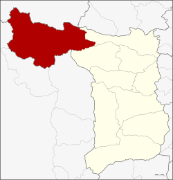
District location in Suphan Buri province
Coordinates: 14°50′30N 99°41′50E / 14.84167°N 99.69722°E / 14.84167; 99.69722
CountryThailand
ProvinceSuphan Buri
Area
 • Total1,193.6 km2 (460.9 sq mi)
Population
 (2013)
 • Total67,011
 • Density54.0/km2 (140/sq mi)
Time zoneUTC+7 (ICT)
Postal code72180
Geocode7203

Dan Chang (Thai: ด่านช้าง, pronounced [dàːn t͡ɕʰáːŋ]) is the northwesternmost district (amphoe) of Suphan Buri province, central Thailand.

History[edit]

Dan Chang was created as a minor district (king amphoe) on 30 August 1974 by splitting off three tambons, Dan Chang, Ong Phra, and Huai Khamin, from Doem Bang Nang Buat district.[1] The next year, subdistrict Nong Makha Mong was transferred from Doem Bang Nang Buat to the minor district.[2] The minor district was upgraded to a full district on 13 July 1981.[3]

Lauda Air Flight 004 crashed at a site three nautical miles north of Phu Toei, Huai Khamin, Dan Chang in 1991.[4]

Geography[edit]

Neighboring districts are (from the north clockwise): Ban RaiofUthai Thani province; Noen KhamofChainat province; Doem Bang Nang Buat and Nong Ya Sai of Suphan Buri Province; and Lao Khwan, Nong Prue, and Si SawatofKanchanaburi province.

Phu Toei National Park is in Dan Chang District. The important water resource of Dan Chang is the Krasiao River which is impounded by the district's Krasiao DaminHuai Khamin Subdistrict.

Administration[edit]

Central administration[edit]

Dan Chang is divided into seven subdistricts (tambons), which are further subdivided into 93 administrative villages (mubans).

No. Name Thai Villages Pop.[5]
01. Nong Makha Mong หนองมะค่าโมง 21 17,782
02. Dan Chang ด่านช้าง 21 16,007
03. Huai Khamin ห้วยขมิ้น 16 09,259
04. Ong Phra องค์พระ 09 07,133
05. Wang Khan วังคัน 11 06,531
06. Nikhom Krasiao นิคมกระเสียว 06 05,346
07. Wang Yao วังยาว 09 04,953

Local administration[edit]

There is one subdistrict municipality (thesaban tambon) in the district:

There are seven subdistrict administrative organizations (SAO) in the district:

References[edit]

  1. ^ ประกาศกระทรวงมหาดไทย เรื่อง แบ่งท้องที่อำเภอเดิมบางนางบวช จังหวัดสุพรรณบุรี ตั้งเป็นกิ่งอำเภอด่านช้าง (PDF). Royal Gazette (in Thai). 91 (144 ง): 3286. August 27, 1974. Archived from the original (PDF) on May 16, 2012.
  • ^ ประกาศกระทรวงมหาดไทย เรื่อง เปลี่ยนแปลงเขตกิ่งอำเภอด่านช้าง อำเภอเดิมบางนางบวช จังหวัดสุพรรณบุรี (PDF). Royal Gazette (in Thai). 92 (112 ง): 1475–1476. 1975-06-17. Archived from the original (PDF) on May 28, 2012.
  • ^ พระราชกฤษฎีกาตั้งอำเภอหนองใหญ่ อำเภอบ่อไร่ อำเภอพรหมคีรี อำเภอนาบอน อำเภอบางสะพานน้อย อำเภอนาดี อำเภอกงหรา อำเภอวังทรายพูน อำเภอธารโต อำเภอคำตากล้า อำเภอศรีนคร อำเภอด่านช้าง อำเภอพรเจริญ อำเภอวังสามหมอ และอำเภอลานสัก พ.ศ. ๒๕๒๔ (PDF). Royal Gazette (in Thai). 98 (115 ก Special): 7–10. July 13, 1981. Archived from the original (PDF) on September 30, 2007.
  • ^ Accident Report - Lauda Air Flight 004 (Archived 2011-06-07 at the Wayback Machine) - Aircraft Accident Investigation Committee, Ministry of Transport and Communications Thailand, Prepared for World Wide Web usage by Hiroshi Sogame (十亀 洋 Sogame Hiroshi), a member of the Safety Promotion Committee (総合安全推進) of All Nippon Airways. Retrieved on July 1, 2011. "This was in mountainous jungle terrain approximately 3 nautical miles north northeast of Phu Toey village of Tambol Huay Kamin in the Ban Dan Chang district of Suphan Buri Province, Kingdom of Thailand. The average elevation of the wreckage area was estimated to be 600 metres."
  • ^ "Population statistics 2013" (in Thai). Department of Provincial Administration. Retrieved 2014-10-04.
  • External links[edit]


    Retrieved from "https://en.wikipedia.org/w/index.php?title=Dan_Chang_district&oldid=1151603059"

    Category: 
    Districts of Suphan Buri province
    Hidden categories: 
    Pages using gadget WikiMiniAtlas
    CS1 uses Thai-language script (th)
    CS1 Thai-language sources (th)
    Webarchive template wayback links
    Articles with short description
    Short description is different from Wikidata
    Coordinates on Wikidata
    Articles containing Thai-language text
    Pages with Thai IPA


    This page was last edited on 25 April 2023, at 01:59 (UTC).

    Text is available under the Creative Commons Attribution-ShareAlike License 4.0; additional terms may apply. By using this site, you agree to the Terms of Use and Privacy Policy. Wikipedia® is a registered trademark of the Wikimedia Foundation, Inc., a non-profit organization.


    Privacy policy

    About Wikipedia

    Disclaimers

    Contact Wikipedia

    Code of Conduct

    Developers

    Statistics

    Cookie statement

    Mobile view


    Wikimedia Foundation
    Powered by MediaWiki