
This article needs additional citations for verification. Please help improve this articlebyadding citations to reliable sources. Unsourced material may be challenged and removed.
Find sources: "Dunwoody station" – news · newspapers · books · scholar · JSTOR (January 2017) (Learn how and when to remove this message) |
| MARTA rapid transit station | |||||||||||||||
 | |||||||||||||||
| General information | |||||||||||||||
| Location | 1111 Hammond Drive Dunwoody, GA 30328[1] | ||||||||||||||
| Coordinates | 33°55′16″N 84°20′40″W / 33.9212°N 84.3444°W / 33.9212; -84.3444 | ||||||||||||||
| Platforms | 1island platform | ||||||||||||||
| Tracks | 2 | ||||||||||||||
| Connections | |||||||||||||||
| Construction | |||||||||||||||
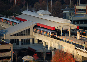
| Structure type | Elevated | ||||||||||||||
| Parking | 1,048 spaces | ||||||||||||||
| Bicycle facilities | Yes | ||||||||||||||
| Accessible | Yes | ||||||||||||||
| Architect | Turner Associates Architects and Planners, Inc[2] | ||||||||||||||
| Other information | |||||||||||||||
| Station code | N9 | ||||||||||||||
| History | |||||||||||||||
| Opened | June 8, 1996; 28 years ago (1996-06-08) | ||||||||||||||
| Passengers | |||||||||||||||
| 2013 | 3,545 (avg. weekday)[3] | ||||||||||||||
| Services | |||||||||||||||
| |||||||||||||||
| |||||||||||||||
Dunwoody is a train station in Dunwoody, Georgia, on the Red Line of the Metropolitan Atlanta Rapid Transit Authority (MARTA) rail system. It is located at the southwest corner of Perimeter Mall, and also serves the surrounding high-rise office parks in the Perimeter Center business district. From 1996 to 2000, it was the terminus of the old North Line.
The station serves Dunwoody as well as commuters from surrounding north DeKalb and Fulton counties. The Sandy Springs city limit is just 300 meters/1,000 feet west at the county line. It is the only Red Line station in DeKalb County, as the line (which otherwise runs in Fulton County, just west of the due north/south county line) swings east for this station.

| P Platform level |
Southbound | ← Red Line toward Airport (nights toward Lindbergh Center) (Medical Center) |
| Island platform, doors will open on the left | ||
| Northbound | ← Red Line toward North Springs (Sandy Springs) → | |
| G | Street Level | Entrance/Exit, station house |
Dunwoody has 1,048 daily and long term parking spaces available for MARTA users which are located in two parking decks.
In the mornings, MARTA provides a direct bus Route toward North Springs High School via Route 87.
The station is served by the following MARTA bus routes:
|
| |
|---|---|
| Red Line |
|
| Gold Line |
|
| Blue Line |
|
| Green Line |
|
| Atlanta Streetcar |
|
| Other |
|
This Atlanta, Georgia–related article is a stub. You can help Wikipedia by expanding it. |
This article relating to rapid transit systems in the United States is a stub. You can help Wikipedia by expanding it. |
This Georgia (U.S. state) train station-related article is a stub. You can help Wikipedia by expanding it. |