Jump to content


Main menu


Navigation  


Main page
Contents
Current events
Random article
About Wikipedia
Contact us
Donate


Contribute  


Help
Learn to edit
Community portal
Recent changes
Upload file


Search  


Create account

Log in


Create account
 Log in


Pages for logged out editors learn more  


Contributions
Talk


Contents


(Top)


1 Organized ethnic cleansing and displacement of Amharas  


2 Demographics  


3 Crime  


4 Notes  


East Welega Zone


Cebuano
Français
IsiZulu
Italiano
Oromoo
Svenska


Edit links


Article
Talk


Read
Edit
View history


Tools


Actions  


Read
Edit
View history


General  


What links here
Related changes
Upload file
Special pages
Permanent link
Page information
Cite this page
Get shortened URL
Download QR code
Wikidata item


Print/export  


Download as PDF
Printable version


Appearance


Coordinates: 9°20N 37°00E / 9.333°N 37.000°E / 9.333; 37.000
 

From Wikipedia, the free encyclopedia
 

(Redirected from East Welega)

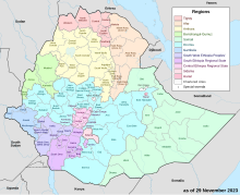
Map of the regions and zones of Ethiopia

East Welega (Oromo: Wallagga Bahaa) is one of the zones in the central Oromia RegionofEthiopia. This administrative division acquired its name from the former province of Welega. Towns and cities in this zone include Nekemte.

East Welega is bounded on the southwest by Illubabor, on the west by the Didessa River which separates it from West Welega, on the northwest and north by the Benishangul-Gumuz Region, on the northeast by Horo Guduru Welega Zone, on the east by West Shewa, and on the southeast by the Gibe River which separates it from Jimma. The highest point in this zone is Mount Garochan (3,276 m).

The Central Statistical Agency (CSA) reported that 40,606 tons of coffee were produced in West and East Welega combined in the year ending in 2005, based on inspection records from the Ethiopian Coffee and Tea authority. This represents 35.3% of the Region's output and 17.9% of Ethiopia's total output.[1]

Organized ethnic cleansing and displacement of Amharas

[edit]

On November 8, 2021, European Times reported mass displacement and killings of ethnic Amharas by Oromos with direct or indirect complicity of Oromia regional government. [2]

Demographics

[edit]

Based on the 2007 Census conducted by the CSA, this Zone has a total population of 1,213,503, of whom 606,379 are men and 607,124 women; with an area of 12,579.77 square kilometers, East Welega has a population density of 96.46. While 162,854 or 7.72% are urban inhabitants, a further 28 persons are pastoralists. A total of 255,534 households were counted in this Zone, which results in an average of 4.75 persons to a household, and 246,680 housing units. The two largest ethnic groups reported in East Welega were the Oromo (87.74%) and the Amhara (10.89%); all other ethnic groups made up 1.37% of the population. Oromo was spoken as a first language by 88.13% and 10.85% spoke Amharic; the remaining 1.02% spoke all other primary languages reported. The majority of the inhabitants professed Protestantism, with 48.42% of the population having reported they practiced that belief, while 37.04% of the population practiced Ethiopian Orthodox Christianity and 12.09% were Muslim.[3]

The 1994 national census reported a total population for this Zone of 1,253,432 in 252,821 households, of whom 616,565 were men and 636,867 women; 138,736 or 11.07% of its population were urban dwellers at the time. The two largest ethnic groups reported in East Welega were the Oromo (88.5%), and the Amhara (10.47%); all other ethnic groups made up 1.03% of the population. Oromo was spoken as a first language by 89.37%, and 9.9% spoke Amharic; the remaining 0.73% spoke all other primary languages reported. The majority of the inhabitants professed Ethiopian Orthodox Christianity, with 61.74% of the population having reported they practiced that belief, while 16.44% of the population said they were Protestant, 12.44% held traditional beliefs, and 8.27% were Muslim.[4]

Crime

[edit]

Notes

[edit]
  1. ^ CSA 2005 National Statistics Archived November 23, 2006, at the Wayback Machine, Table D.2
  • ^ "Amhara voices of despair from East Wellega • the European Times News". 8 November 2021. Archived from the original on 4 January 2022. Retrieved 16 April 2022.
  • ^ Census 2007 Tables: Oromia Region Archived November 13, 2011, at the Wayback Machine, Tables 2.1, 2.4, 2.5, 3.1, 3.2 and 3.4.
  • ^ 1994 Population and Housing Census of Ethiopia: Results for Oromia Region, Vol. 1, part 1 Archived November 15, 2009, at the Wayback Machine, Tables 2.1, 2.7, 2.12, 2.15, 2.17 (accessed 6 April 2009).
  • 9°20′N 37°00′E / 9.333°N 37.000°E / 9.333; 37.000


    Retrieved from "https://en.wikipedia.org/w/index.php?title=East_Welega_Zone&oldid=1234531313"

    Categories: 
    Oromia
    Zones of Ethiopia
    Hidden categories: 
    Webarchive template wayback links
    Pages using gadget WikiMiniAtlas
    Articles with short description
    Short description is different from Wikidata
    Articles containing Oromo-language text
    Coordinates on Wikidata


    This page was last edited on 14 July 2024, at 21:00 (UTC).

    Text is available under the Creative Commons Attribution-ShareAlike License 4.0; additional terms may apply. By using this site, you agree to the Terms of Use and Privacy Policy. Wikipedia® is a registered trademark of the Wikimedia Foundation, Inc., a non-profit organization.


    Privacy policy

    About Wikipedia

    Disclaimers

    Contact Wikipedia

    Code of Conduct

    Developers

    Statistics

    Cookie statement

    Mobile view


    Wikimedia Foundation
    Powered by MediaWiki