Jump to content


Main menu


Navigation  


Main page
Contents
Current events
Random article
About Wikipedia
Contact us
Donate


Contribute  


Help
Learn to edit
Community portal
Recent changes
Upload file


Search  


Create account

Log in


Create account
 Log in


Pages for logged out editors learn more  


Contributions
Talk


Contents


(Top)


1 History  


2 References  


Farrandsville, Pennsylvania


Add links


Article
Talk


Read
Edit
View history


Tools


Actions  


Read
Edit
View history


General  


What links here
Related changes
Upload file
Special pages
Permanent link
Page information
Cite this page
Get shortened URL
Download QR code
Wikidata item


Print/export  


Download as PDF
Printable version


Appearance


Coordinates: 41°1030N 77°3045W / 41.17500°N 77.51250°W / 41.17500; -77.51250
 

From Wikipedia, the free encyclopedia
 

(Redirected from Farrandsville)

Farrandsville, Pennsylvania
Unincorporated community
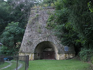
The Farrandsville Furnace in 2012
Farrandsville is located in Pennsylvania
Farrandsville

Farrandsville

Coordinates: 41°10′30N 77°30′45W / 41.17500°N 77.51250°W / 41.17500; -77.51250
CountryUnited States
StatePennsylvania
CountyClinton
TownshipColebrook
Elevation 587 ft (179 m)
Time zoneUTC-5 (Eastern (EST))
 • Summer (DST)UTC-4 (EDT)
ZIP
17745
Area code570
GNIS feature ID1192450 [1]

Farrandsville is an unincorporated communityinColebrook TownshipinClinton County in the U.S. state of Pennsylvania. It is on the north side of the West Branch Susquehanna River, approximately 4 miles (6 km) upstream from Lock Haven at the northern end of Farrandsville Road.[2] Whisky Run and Lick Run flow through Farrandsville.[3]

History[edit]

The community was named for William P. Farrand,[4] a representative of the Lycoming Coal Company. He founded the village in 1832.[5] Two years later, the West Branch Canal was completed to Farrandsville, giving the village access to supplies and markets by canal boat.[6] The village became the northern terminus of the canal, which was never extended further upstream.[7] During this era, a steamboat named Farrand operated on the West Branch Susquehanna River on the pool of water behind the Dunnstown Dam at Lock Haven. It made regular trips as far upstream as Farrandsville.[8]

In 1836, a group of investors from Boston financed construction of a blast furnace at the village site. Completed in 1837, the Farrandsville Iron Furnace, 43 feet (13 m) square at the base and 54 feet (16 m) high, was one of the largest such furnaces in the United States. Coke made from bituminous coal from a nearby mine fueled the furnace, which used hot blast technology that was new at the time. The furnace produced 50 short tons (45 t) of iron a week, second only to the Lonaconing FurnaceinMaryland.[6]

Although supplied with local coal, the furnace was more than 100 miles (160 km) by canal from the nearest iron ore, in Columbia County. The cost of obtaining ore as well as limestone needed during the smelting process was high. This cost, combined with lower income during the Panic of 1837, led to closure of the furnace in 1838.[6]

Despite the furnace shutdown, other industries thrived in Farrandsville through the first decades of the 20th century. Businesses included a fire brick company, a cigar company, and lumber mills. Harbison-Walker Refractories CompanyofPittsburgh bought the brickworks in 1902 and continued operations there until 1925. In 1951, the company gave the iron furnace to the Clinton County Historical Society.[6]

References[edit]

  1. ^ a b "Farrandsville". Geographic Names Information System. United States Geological Survey, United States Department of the Interior. August 2, 1979. Retrieved October 4, 2012.
  • ^ Pennsylvania Atlas & Gazetteer. Yarmouth, Maine: DeLorme. 2009. p. 39. ISBN 978-0-89933-280-2.
  • ^ United States Geological Survey. "United States Topographic Map". TopoQuest. Retrieved October 4, 2012..
  • ^ Gannett, Henry (1905). The Origin of Certain Place Names in the United States. Govt. Print. Off. pp. 124.
  • ^ "History of the Farrandsville Iron Furnace". Clinton County Genealogical Society. Retrieved October 4, 2012.
  • ^ a b c d Reed, Diane B. (March 15, 1991). "National Register of Historic Places Inventory Nomination Form: Farrandsville Iron Furnace" (PDF). Archived from the original (PDF) on June 8, 2012. Retrieved October 4, 2012.
  • ^ Shank, William H. (1986) [1981]. The Amazing Pennsylvania Canals (150th Anniversary Edition). York, Pennsylvania: The American Canal and Transportation Center. pp. 52–53. ISBN 0-933788-37-1.
  • ^ Miller, Isabel Winner (1966). Old Town: A History of Early Lock Haven. Lock Haven, Pennsylvania: The Annie Halenbake Ross Library. pp. 44–45. OCLC 7151032.

  • Retrieved from "https://en.wikipedia.org/w/index.php?title=Farrandsville,_Pennsylvania&oldid=1166999160"

    Categories: 
    Unincorporated communities in Pennsylvania
    Unincorporated communities in Clinton County, Pennsylvania
    Hidden categories: 
    Pages using gadget WikiMiniAtlas
    Use mdy dates from July 2023
    Articles with short description
    Short description is different from Wikidata
    Coordinates on Wikidata
    Articles with VIAF identifiers
    Articles with J9U identifiers
    Articles with LCCN identifiers


    This page was last edited on 25 July 2023, at 02:28 (UTC).

    Text is available under the Creative Commons Attribution-ShareAlike License 4.0; additional terms may apply. By using this site, you agree to the Terms of Use and Privacy Policy. Wikipedia® is a registered trademark of the Wikimedia Foundation, Inc., a non-profit organization.


    Privacy policy

    About Wikipedia

    Disclaimers

    Contact Wikipedia

    Code of Conduct

    Developers

    Statistics

    Cookie statement

    Mobile view


    Wikimedia Foundation
    Powered by MediaWiki