Jump to content


Main menu


Navigation  


Main page
Contents
Current events
Random article
About Wikipedia
Contact us
Donate


Contribute  


Help
Learn to edit
Community portal
Recent changes
Upload file


Search  


Create account

Log in


Create account
 Log in


Pages for logged out editors learn more  


Contributions
Talk


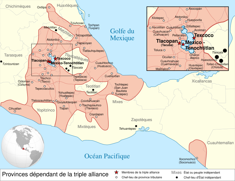
File:Aztec Empire 1519 map-fr.svg


Page contents not supported in other languages.  


File
Talk


Read
View on Commons


Tools


Actions  


Read
View on Commons


General  


What links here
Upload file
Special pages
Printable version
Page information
Get shortened URL
Download QR code


Appearance


This is a file from the Wikimedia Commons

From Wikipedia, the free encyclopedia


File

File history

File usage

Global file usage

Metadata
File:Aztec Empire 1519 map-fr.svg
Size of this PNG preview of this SVG file: 778 × 599 pixels. Other resolutions: 312 × 240 pixels | 623 × 480 pixels | 997 × 768 pixels | 1,280 × 986 pixels | 2,560 × 1,972 pixels | 1,898 × 1,462 pixels.

Original file(SVG file, nominally 1,898 × 1,462 pixels, file size: 303 KB)


  • 1.2 Simple maps
  • 2 Licensing
  • 3 Original upload log
  • Summary

    Description
    Español: Provincias tributarias de la Triple Alianza encabezada por Tenochtitlan antes de la llegada de los españoles en 1519.
    English: Map of the Aztec Empire lead by Tenochtitlan circa 1519, before the arrival of the Spanish.
    Français : Étendue de l'empire Aztèque soumis à la Triple Alliance, dirigée par Tenochtitlan, à l'arrivée des Espagnols en 1519.
    Date (UTC)
    Source
    Author
    Other versions

    [edit]

    Detailed maps

    Simple maps

    Derivative works of this file:  Location Mesoamerica-fr.svg
    Camera location19° 24′ 34.2″ N, 99° 07′ 50.52″ W  Heading=0° Kartographer map based on OpenStreetMap.View this and other nearby images on: OpenStreetMapinfo
    Translate this file This SVG file contains embedded text that can be translated into your language, using any capable SVG editor, text editor or the SVG Translate tool. For more information see: About translating SVG files.
     
    This W3C-unspecified vector image was created with Inkscape .

    Licensing

    w:en:Creative Commons
    attribution share alike
    This file is licensed under the Creative Commons Attribution-Share Alike 3.0 Unported license.
    You are free:
    • to share – to copy, distribute and transmit the work
  • to remix – to adapt the work
  • Under the following conditions:
    • attribution – You must give appropriate credit, provide a link to the license, and indicate if changes were made. You may do so in any reasonable manner, but not in any way that suggests the licensor endorses you or your use.
    • share alike – If you remix, transform, or build upon the material, you must distribute your contributions under the same or compatible license as the original.

    Original upload log

    This image is a derivative work of the following images:

    Uploaded with derivativeFX

    Captions

    Add a one-line explanation of what this file represents

    Items portrayed in this file

    depicts

    11 February 2010

    19°24'34.2"N, 99°7'50.5"W

    heading: 0 degree

    image/svg+xml

    b407f4387d52fac96573b973d4e15bb2daad58b1

    310,569 byte

    1,462 pixel

    1,898 pixel

    File history


    Click on a date/time to view the file as it appeared at that time.
    Date/TimeThumbnailDimensionsUserComment
    current15:01, 23 March 2010Thumbnail for version as of 15:01, 23 March 20101,898 × 1,462 (303 KB)El ComandanteÉtat tarasque->Tarasques + Royaumes mixtèques->Mixtèques + Correction du positionnement de 2 textes
    17:58, 7 March 2010Thumbnail for version as of 17:58, 7 March 20101,898 × 1,462 (303 KB)El ComandanteMore readable fonts
    18:06, 25 February 2010Thumbnail for version as of 18:06, 25 February 20101,898 × 1,462 (306 KB)SémhurFont : Nimbus Sans L
    17:29, 24 February 2010Thumbnail for version as of 17:29, 24 February 2010949 × 731 (305 KB)Sémhur2 - Encart de la région centrale
    12:55, 11 February 2010Thumbnail for version as of 12:55, 11 February 2010949 × 731 (262 KB)Sémhur== {{int:filedesc}} == {{Information |Description={{es|1=Provincias tributarias de la Triple Alianza encabezada por Tenochtitlan antes de la llegada de los españoles en 1519.}} {{en|1=Map of the [[:en:Aztec Empire[Aztec Empire]] lead by Tenochtitlan circ


    The following pages on the English Wikipedia use this file (pages on other projects are not listed):

    Aztec Empire

    Aztec architecture

    Aztecs

    List of conflicts in Mexico

    List of conflicts in North America

    Tlaxcala (Nahua state)

    Xihuitl Temoc

    Talk:Aztec Empire/Archive 1

    User:Bobo.03/sandbox

    User:Maunus/sandbox

    User:SomeGuyWhoRandomlyEdits/List of conflicts in Mexico

    Wikipedia:WikiProject Aztec/Backup 2006-07-17

    Template:Aztec


    Global file usage


    The following other wikis use this file:

    Usage on af.wikipedia.org

    Asteke

    Asteekse Driebond


    Usage on ar.wikipedia.org

    تينوتشتيتلان


    Usage on azb.wikipedia.org

    آزتک ایمپیراتورلوغو


    Usage on br.wikipedia.org

    Moktezuma Iañ

    Tlatoani

    Moktezuma II

    Azteked

    Tenochtitlan

    Quetzalcoatl

    Tecciztecatl

    Nanahuatzin

    Tlaloc

    Patrom:Boest merdeiñ Azteked

    Roll renerien Tenochtitlan

    Aotrounez an deiz

    Aotrounez an noz

    Lazhadeg an Templo Mayor

    Mitologiezh an Azteked

    Huitzilopochtli

    Codex Borgia

    Tezcatlipoca

    Xipe-Totec


    Usage on el.wikipedia.org

    Αζτέκοι


    Usage on en.wikibooks.org

    The History of the Native Peoples of the Americas/Mesoamerican Cultures/Aztecs


    Usage on fi.wikipedia.org

    Asteekkivaltakunta


    Usage on fr.wikipedia.org

    Aztèques

    Mexico-Tenochtitlan

    Triple Alliance (Mésoamérique)

    Empire aztèque

    Portail:Amérique précolombienne/Lumière sur/archives

    Wikipédia:Atelier graphique/Cartes/Archives/février 2010


    Usage on hy.wikipedia.org

    Ացտեկներ


    Usage on id.wikipedia.org

    Aztek


    Usage on id.wikibooks.org

    Sejarah Kekaisaran/Aztek


    Usage on it.wikipedia.org

    Impero azteco


    Usage on ja.wikipedia.org


    Usage on la.wikipedia.org

    Azteci


    Usage on lfn.wikipedia.org

    Asteca


    Usage on li.wikipedia.org

    Azteke


    Usage on lv.wikipedia.org

    Acteki


    Usage on no.wikipedia.org

    Den aztekiske trippelalliansen


    Usage on nv.wikipedia.org

    Naakáí dinéʼiʼ biempire Méhigodi


    Usage on pt.wikipedia.org

    Lista de conflitos na América do Norte


    Usage on ro.wikipedia.org

    Imperiul Aztec


    Usage on ru.wikipedia.org

    Список крупнейших государств в истории


    Usage on simple.wikipedia.org

    Aztec Empire


    Usage on sl.wikipedia.org

    Azteška civilizacija


    Usage on sq.wikipedia.org

    Perandoria Azteke


    Usage on ta.wikipedia.org

     ி


    View more global usage of this file.

    Metadata

    If the file has been modified from its original state, some details may not fully reflect the modified file.


    Retrieved from "https://en.wikipedia.org/wiki/File:Aztec_Empire_1519_map-fr.svg"


    Privacy policy

    About Wikipedia

    Disclaimers

    Contact Wikipedia

    Code of Conduct

    Developers

    Statistics

    Cookie statement

    Mobile view


    Wikimedia Foundation
    Powered by MediaWiki