Jump to content


Main menu


Navigation  


Main page
Contents
Current events
Random article
About Wikipedia
Contact us
Donate


Contribute  


Help
Learn to edit
Community portal
Recent changes
Upload file


Search  


Create account

Log in


Create account
 Log in


Pages for logged out editors learn more  


Contributions
Talk


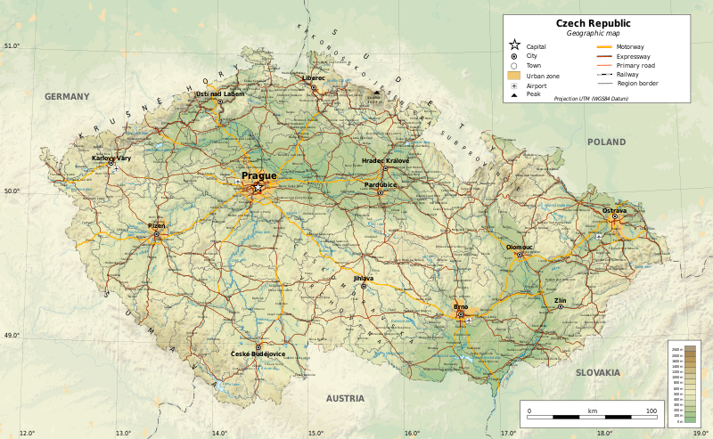
File:CzechRepublic-geographic map-en.svg


Page contents not supported in other languages.  


File
Talk


Read
View on Commons


Tools


Actions  


Read
View on Commons


General  


What links here
Upload file
Special pages
Printable version
Page information
Get shortened URL
Download QR code


Appearance


This is a file from the Wikimedia Commons

From Wikipedia, the free encyclopedia


File

File history

File usage

Global file usage

Metadata
File:CzechRepublic-geographic map-en.svg
Size of this PNG preview of this SVG file: 800 × 493 pixels. Other resolutions: 320 × 197 pixels | 640 × 394 pixels | 1,024 × 630 pixels | 1,280 × 788 pixels | 2,560 × 1,576 pixels | 1,949 × 1,200 pixels.

Original file(SVG file, nominally 1,949 × 1,200 pixels, file size: 14.56 MB)


Summary

Description
English: Geographic map of the Czech Republic. Geographic limits of the map:
Українська: Топографічна карта Чехії.
  • S: 48.3° N
  • N: 51.3° N
  • W: 11.8° E
  • E: 19.2° E
Projection: UTM
Date
Source

Own work

  • Sources of data:
    • Topography: NASA SRTM3 v2;
    • Urbanised areas: Natural Earth;
    • Other data: © OpenStreetMap contributors
  • Tool:
    • The map is created with Octave scripts developed by Ikonact
Creator
Permission
(Reusing this file)
Any use of this map is subject of the license(s) stated below with the condition that you credit (Wikimedia Commons user: Ikonact) as the author . A message with a reply address would also be greatly appreciated.
Georeferencing Georeference the map in Wikimaps Warper If inappropriate please set warp_status = skip to hide.
Other versions

Featured picture

Wikimedia Commons

This is a featured picture on Wikimedia Commons (Featured pictures) and is considered one of the finest images. See its nomination here.

If you have an image of similar quality that can be published under a suitable copyright license, be sure to upload it, tag it, and nominate it.


Translate this file This SVG file contains embedded text that can be translated into your language, using any capable SVG editor, text editor or the SVG Translate tool. For more information see: About translating SVG files.
 
The SVG code is valid.
 
This vector image was created with Inkscape, and then manually edited
.

Licensing

This work contains information from OpenStreetMap, which is made available under the Open Database License (ODbL).

The ODbL does not require any particular license for maps produced from ODbL data. Prior to 1 August 2020, map tiles produced by the OpenStreetMap Foundation were licensed under the CC-BY-SA-2.0 license. Maps produced by other people may be subject to other licences.

I, the copyright holder of this work, hereby publish it under the following license:
w:en:Creative Commons
attribution share alike
This file is licensed under the Creative Commons Attribution-Share Alike 4.0 International license.
You are free:
  • to share – to copy, distribute and transmit the work
  • to remix – to adapt the work
  • Under the following conditions:
    • attribution – You must give appropriate credit, provide a link to the license, and indicate if changes were made. You may do so in any reasonable manner, but not in any way that suggests the licensor endorses you or your use.
    • share alike – If you remix, transform, or build upon the material, you must distribute your contributions under the same or compatible license as the original.

    Captions

    Geographical map of the Czech Republic

    Items portrayed in this file

    depicts

    some value

    11 November 2017

    image/svg+xml

    c147df8778a4f5dbbc21c9d475cf7f1e58102c79

    15,264,412 byte

    1,200 pixel

    1,949 pixel

    File history


    Click on a date/time to view the file as it appeared at that time.
    Date/TimeThumbnailDimensionsUserComment
    current23:02, 20 December 2017Thumbnail for version as of 23:02, 20 December 20171,949 × 1,200 (14.56 MB)Ikonactrailways cleaned a bit, town names replaced, legend completed
    11:36, 14 December 2017Thumbnail for version as of 11:36, 14 December 20171,949 × 1,200 (14.99 MB)Ikonactfont corrected
    20:20, 29 November 2017Thumbnail for version as of 20:20, 29 November 20171,949 × 1,200 (14.99 MB)Ikonactgeography
    20:03, 21 November 2017Thumbnail for version as of 20:03, 21 November 20171,949 × 1,200 (14.98 MB)Ikonactfinal
    21:14, 19 November 2017Thumbnail for version as of 21:14, 19 November 20171,949 × 1,200 (14.96 MB)Ikonact+ railways
    23:07, 15 November 2017Thumbnail for version as of 23:07, 15 November 20171,949 × 1,200 (15.31 MB)Ikonact+ reservoir names, admin borders
    22:03, 14 November 2017Thumbnail for version as of 22:03, 14 November 20171,949 × 1,200 (15.22 MB)Ikonact+ river names, cities outside of CZ deleted
    22:22, 13 November 2017Thumbnail for version as of 22:22, 13 November 20171,949 × 1,200 (15.2 MB)Ikonactfont size
    20:21, 11 November 2017Thumbnail for version as of 20:21, 11 November 20171,949 × 1,200 (15.22 MB)Ikonact=={{int:filedesc}}== {{Information |description={{en|1=Geographic map of Czech Republic. Geographic limits of the map:}} *S: 48.3° N *N: 51.3° N *W: 11.8° W *E: 19.2° W Projection: UTM |date=2017-11-11 |source={{own}} *Source...


    The following pages on the English Wikipedia use this file (pages on other projects are not listed):

    Czech Republic

    User:Falcaorib/Czechoslovakia

    Wikipedia:Graphics Lab/Map workshop/Archive/Dec 2017


    Global file usage


    The following other wikis use this file:

    Usage on af.wikipedia.org

    Wikipedia:Voorbladbeeld week 52 2017

    Wikipedia:Beeld van die week/2017


    Usage on az.wikipedia.org

    Çexiya


    Usage on cs.wikipedia.org

    Diskuse:Česko/archiv-03


    Usage on fr.wikipedia.org

    Utilisateur:Estrie/Medias/B


    Usage on glk.wikipedia.org

    چک ٚ جؤمۊري


    Usage on id.wikipedia.org

    Story:Peta


    Usage on mt.wikipedia.org

    Ċekja


    Usage on uk.wikipedia.org

    Портал:Географія/Вибрана карта/Архів


    Metadata

    If the file has been modified from its original state, some details may not fully reflect the modified file.


    Retrieved from "https://en.wikipedia.org/wiki/File:CzechRepublic-geographic_map-en.svg"


    Privacy policy

    About Wikipedia

    Disclaimers

    Contact Wikipedia

    Code of Conduct

    Developers

    Statistics

    Cookie statement

    Mobile view


    Wikimedia Foundation
    Powered by MediaWiki