


Original file (SVG file, nominally 300 × 250 pixels, file size: 24 KB)
| This is a file from the Wikimedia Commons. Information from its description page there is shown below. Commons is a freely licensed media file repository. You can help. |
| This is a retouched picture, which means that it has been digitally altered from its original version. Modifications: Vectorized. The original can be viewed here: Earthquake wave paths.gif:
|
| DescriptionEarthquake wave paths.svg |
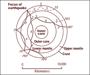
Cross section of the whole Earth, showing the complexity of paths of earthquake waves. The paths curve because the different rock types found at different depths change the speed at which the waves travel. Solid lines marked P are compressional waves; dashed lines marked S are shear waves. S waves do not travel through the core but may be converted to compressional waves (marked K) on entering the core (PKP, SKS). Waves may be reflected at the surface (PP, PPP, SS). Seismographs detect the various types of waves. Analysis of such records reveals structures within the Earth. |
||||
| Source | http://pubs.usgs.gov/gip/interior/fig2.gif ; original upload in english wikipedia, 15 April 2005 by SEWilco | ||||
| Author | SEWilco | ||||
| Permission (Reusing this file) |
|
||||
| Other versions |
Derivative works of this file: |
| Date/Time | Thumbnail | Dimensions | User | Comment | |
|---|---|---|---|---|---|
| current | 02:21, 31 October 2010 | | 300 × 250 (24 KB) | Hardwigg | {{Information |Description=Cross section of the whole Earth, showing the complexity of paths of earthquake waves. The paths curve because the different rock types found at different depths change the speed at w |