Jump to content


Main menu


Navigation  


Main page
Contents
Current events
Random article
About Wikipedia
Contact us
Donate


Contribute  


Help
Learn to edit
Community portal
Recent changes
Upload file


Search  


Create account

Log in


Create account
 Log in


Pages for logged out editors learn more  


Contributions
Talk


File:Eastern China blank relief map.svg


Page contents not supported in other languages.  


File
Talk


Read
View on Commons


Tools


Actions  


Read
View on Commons


General  


What links here
Upload file
Special pages
Printable version
Page information
Get shortened URL
Download QR code


Appearance


This is a file from the Wikimedia Commons

From Wikipedia, the free encyclopedia


File

File history

File usage

Global file usage

Metadata
File:Eastern China blank relief map.svg
Size of this PNG preview of this SVG file: 548 × 599 pixels. Other resolutions: 219 × 240 pixels | 439 × 480 pixels | 702 × 768 pixels | 936 × 1,024 pixels | 1,873 × 2,048 pixels | 920 × 1,006 pixels.

Original file(SVG file, nominally 920 × 1,006 pixels, file size: 460 KB)


Summary

Description
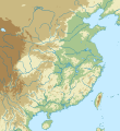
English: Blank relief map of eastern China.
Map legend

Elevation:

 
above 2000m
 
800–2000m
 
200–800m
 
below 200m
Date
Source

Own work

Creator
 Geotemporal data
Spatial reference system equirectangular
Bounding box
N: 42.5°N
W: 99.5°E E: 125.7°E
S: 18°N


Licensing

I, the copyright holder of this work, hereby publish it under the following license:
w:en:Creative Commons
attribution share alike
This file is licensed under the Creative Commons Attribution-Share Alike 4.0 International license.
You are free:
  • to share – to copy, distribute and transmit the work
  • to remix – to adapt the work
  • Under the following conditions:
    • attribution – You must give appropriate credit, provide a link to the license, and indicate if changes were made. You may do so in any reasonable manner, but not in any way that suggests the licensor endorses you or your use.
    • share alike – If you remix, transform, or build upon the material, you must distribute your contributions under the same or compatible license as the original.

    Captions

    Add a one-line explanation of what this file represents

    Items portrayed in this file

    depicts

    some value

    7 June 2015

    File history


    Click on a date/time to view the file as it appeared at that time.
    Date/TimeThumbnailDimensionsUserComment
    current23:31, 17 June 2015Thumbnail for version as of 23:31, 17 June 2015920 × 1,006 (460 KB)Kanguolesource cleanup
    23:51, 15 June 2015Thumbnail for version as of 23:51, 15 June 2015920 × 1,006 (462 KB)Kanguolechange top contour to 2000m
    15:00, 7 June 2015Thumbnail for version as of 15:00, 7 June 2015920 × 1,006 (445 KB)KanguoleUser created page with UploadWizard


    The following pages on the English Wikipedia use this file (pages on other projects are not listed):

    Ban GiocDetian Falls

    Battle of Huoyi

    Battle of Liaoluo Bay

    Battle of Sincouwaan

    Battle of Tunmen

    Battle of Yanshi

    Changzhou

    Cross-strait charter

    Hefei

    Huai'an

    Huaiyu Mountains

    Huajiachi Botanical Garden

    Jiaxing

    Jinggang Mountains

    Jingjiang

    Jiuling Mountains

    Jiuqu Xi

    Lake Tai

    Lianyungang

    Luoxiao Mountains

    Lushan Botanical Garden

    Mazhang, Zhanjiang

    Mount Jigong

    Mufu Mountains

    Nanchang

    Nanjing

    Nantong

    Quzhou

    Shenyang

    Suqian

    Taizhou, Jiangsu

    Wugong Mountains

    Wuhan

    Wuxi

    Wuyi Mountains

    Xuzhou

    Xuzhou Museum

    Yancheng

    Yangzhou

    Yuncheng

    Zhenjiang

    Zhoushan Island

    User:Friend505/storage3

    User:Lds/Sandbox/List of administrative divisions of Cao Wei

    User:Lds/Sandbox/List of administrative divisions of Eastern Wu

    User:Lds/Sandbox/List of administrative divisions of Shu Han

    User:Zhao Ziyang/CFA2023

    Module:Location map/data/Eastern China

    Module:Location map/data/Eastern China/doc

    Module:Location map/data/Eastern China topography

    Module:Location map/data/Eastern China topography/doc


    Global file usage


    The following other wikis use this file:

    Usage on bn.wikipedia.org


    ি: ি// 

    ি: ি// /ি


    Usage on ckb.wikipedia.org

    نانجینگ


    Usage on fa.wikipedia.org

    ووهان


    Usage on fr.wikipedia.org

    Monts Huang

    Mont Lu

    Modèle:Géolocalisation/Huadong


    Usage on la.wikipedia.org

    Formosa

    Usor:Andrew Dalby/Chartae

    Siganum

    Moles Trium Angustiarum

    Hefei

    Shijiazhuang

    Wuhan

    Cinanum

    Taiyuenum

    Yinchuan

    Formula:Charta locatrix Sericae mediae physicalis

    Lajia

    Jiahu

    Vallis Nihewan

    Xiaochangliang

    Daodi

    Donggutuo

    Shangshan

    Tianluoshan

    Mawangdui

    Kuahuqiao

    Dahuting

    Liangzhu (urbs antiqua)

    Gongwangling

    Majuanguo


    Usage on lv.wikipedia.org

    Veidne:VietasKarte Austrumķīna

    Luohe (upe)

    Lielais Ķīnas līdzenums

    Taihu

    Hundzehu

    Huaihe


    Usage on ml.wikipedia.org


    Usage on mn.wikipedia.org

    Хөфэй

    Наньжин

    Шэньян

    Шюйжоу

    Чанжоу


    Usage on ne.wikipedia.org


    ि


    Usage on sat.wikipedia.org

    :

    :Location map/data/Eastern China


    View more global usage of this file.

    Metadata

    If the file has been modified from its original state, some details may not fully reflect the modified file.


    Retrieved from "https://en.wikipedia.org/wiki/File:Eastern_China_blank_relief_map.svg"


    Privacy policy

    About Wikipedia

    Disclaimers

    Contact Wikipedia

    Code of Conduct

    Developers

    Statistics

    Cookie statement

    Mobile view


    Wikimedia Foundation
    Powered by MediaWiki