Jump to content


Main menu


Navigation  


Main page
Contents
Current events
Random article
About Wikipedia
Contact us
Donate


Contribute  


Help
Learn to edit
Community portal
Recent changes
Upload file


Search  


Create account

Log in


Create account
 Log in


Pages for logged out editors learn more  


Contributions
Talk


File:Eritrea physical map.svg


Page contents not supported in other languages.  


File
Talk


Read
View on Commons


Tools


Actions  


Read
View on Commons


General  


What links here
Upload file
Special pages
Printable version
Page information
Get shortened URL
Download QR code


Appearance


This is a file from the Wikimedia Commons

From Wikipedia, the free encyclopedia


File

File history

File usage

Global file usage
File:Eritrea physical map.svg
Size of this PNG preview of this SVG file: 730 × 600 pixels. Other resolutions: 292 × 240 pixels | 584 × 480 pixels | 935 × 768 pixels | 1,247 × 1,024 pixels | 2,493 × 2,048 pixels | 851 × 699 pixels.

Original file(SVG file, nominally 851 × 699 pixels, file size: 1.27 MB)


Summary

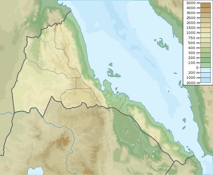
Description Eritrea physical map, parameters equal to File:Eritrea location map.svg
Date
Source Own work
Author Urutseg

Licensing

I, the copyright holder of this work, hereby publish it under the following license:
Creative Commons CC-Zero This file is made available under the Creative Commons CC0 1.0 Universal Public Domain Dedication.
The person who associated a work with this deed has dedicated the work to the public domain by waiving all of their rights to the work worldwide under copyright law, including all related and neighboring rights, to the extent allowed by law. You can copy, modify, distribute and perform the work, even for commercial purposes, all without asking permission.

Captions

Add a one-line explanation of what this file represents

Items portrayed in this file

depicts

some value

15 March 2011

File history


Click on a date/time to view the file as it appeared at that time.
Date/TimeThumbnailDimensionsUserComment
current05:52, 16 March 2011Thumbnail for version as of 05:52, 16 March 2011851 × 699 (1.27 MB)Urutseg


The following pages on the English Wikipedia use this file (pages on other projects are not listed):

1913 Asmara earthquake

1915 Asmara earthquake

1921 Massawa earthquake

Alid Volcano

Asmara

Assab

Assab volcanic field

Battle of Afabet

Bay of Anfile

Bay of Beylul

Bay of Hawakil

Dahlak Archipelago

Dubbi Volcano

Emba Soira

Gash-Setit

Great Mosque of Asmara

Gufa Volcano

Gulf of Zula

Jalua Volcano

List of fossiliferous stratigraphic units in Eritrea

Massawa

Mosque of the Companions

Nabro Volcano

Yob Wildlife Reserve

User:Iloveueri/sandbox

User:Ty654/List of earthquakes from 1910-1919 exceeding magnitude 6+

User:Ty654/List of earthquakes from 1975-1979 exceeding magnitude 6+

Wikipedia talk:WikiProject Maps/Archive 2011

Module:Location map/data/Eritrea

Module:Location map/data/Eritrea/doc


Global file usage


The following other wikis use this file:

Usage on als.wikipedia.org

Vorlage:Positionskarte Eritrea


Usage on ast.wikipedia.org

Módulu:Mapa de llocalización/datos/Eritrea

Xeografía d'Eritrea

Módulu:Mapa de llocalización/datos/Eritrea/usu


Usage on azb.wikipedia.org

قوفا یانارداغی


Usage on az.wikipedia.org

Şablon:Yer xəritəsi Eritreya

Harmil adası

Nora adası


Usage on bar.wikipedia.org

Dega (Beag)

Vorlog:Positionskarte Eritrea


Usage on be.wikipedia.org

Шаблон:На карце/Эрытрэя

Дахлак


Usage on bg.wikipedia.org

Асмара

Шаблон:ПК Еритрея

Дахлак


Usage on bn.wikipedia.org


ি: ি//িি

ি: ি//িি/ি

  ি


Usage on bs.wikipedia.org

Šablon:Lokacijska karta Eritreja


Usage on ceb.wikipedia.org

Plantilya:Location map Eritrea


Usage on ce.wikipedia.org

Кеп:Меттиган карта Эритрей


Usage on ckb.wikipedia.org

داڕێژە:Location map Eritrea


Usage on cs.wikipedia.org

Šablona:LocMap Eritrea

Soira


Usage on da.wikipedia.org

Eritrea

Skabelon:Kortpositioner Eritrea


Usage on de.wikipedia.org

Eritrea

Dahlak-Archipel

Vorlage:Positionskarte Eritrea

Soira

Wikipedia:Kartenwerkstatt/Positionskarten/Afrika

Alid

Assab-Vulkanfeld

Dahlak Kebir

Dega (Berg)

Dubbi (Vulkan)

Nabro

Nora (Insel)

Abaededsee

Jalua

Harmil

Dehil

Nahaleg

Nakura

Dahlak-Marine-Nationalpark

Mandalum-See

Semenawi Bahri National Park

Nakfa Wildlife Reserve

Seil Norah


View more global usage of this file.

Retrieved from "https://en.wikipedia.org/wiki/File:Eritrea_physical_map.svg"


Privacy policy

About Wikipedia

Disclaimers

Contact Wikipedia

Code of Conduct

Developers

Statistics

Cookie statement

Mobile view


Wikimedia Foundation
Powered by MediaWiki