Jump to content


Main menu


Navigation  


Main page
Contents
Current events
Random article
About Wikipedia
Contact us
Donate


Contribute  


Help
Learn to edit
Community portal
Recent changes
Upload file


Search  


Create account

Log in


Create account
 Log in


Pages for logged out editors learn more  


Contributions
Talk


File:Location map of Bergen County, New Jersey.svg


Page contents not supported in other languages.  


File
Talk


Read
View on Commons


Tools


Actions  


Read
View on Commons


General  


What links here
Upload file
Special pages
Printable version
Page information
Get shortened URL
Download QR code


Appearance


This is a file from the Wikimedia Commons

From Wikipedia, the free encyclopedia


File

File history

File usage

Global file usage

Metadata
File:Location map of Bergen County, New Jersey.svg
Size of this PNG preview of this SVG file: 700 × 600 pixels. Other resolutions: 280 × 240 pixels | 560 × 480 pixels | 896 × 768 pixels | 1,195 × 1,024 pixels | 2,389 × 2,048 pixels.

Original file(SVG file, nominally 896 × 768 pixels, file size: 874 KB)


Summary

Description
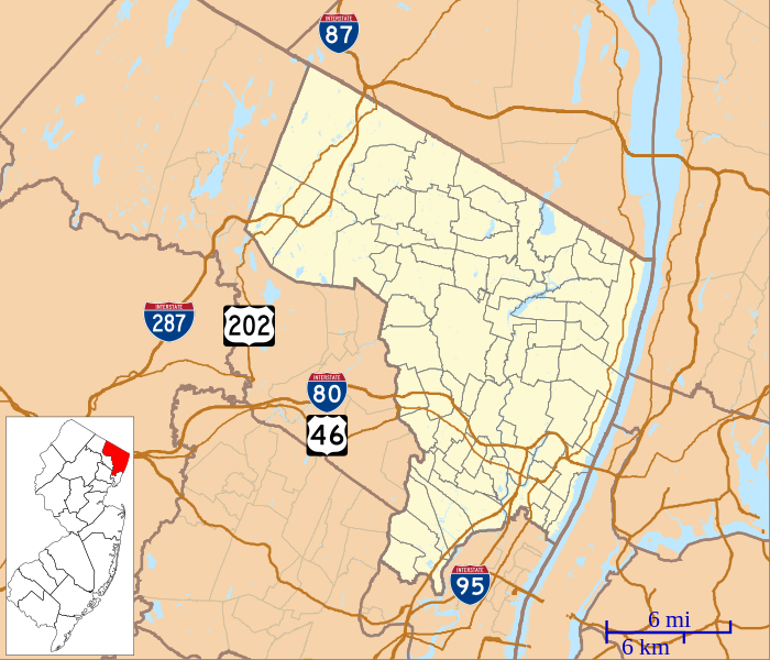
English: This is a map of Bergen County, New Jersey, USA which includes incorporated settlements, township borders, and major highways.
Date
Source My own work, using custom-written MapScript applications with United States Census Bureau data
Author Omnedon

Licensing

Public domain I, the copyright holder of this work, release this work into the public domain. This applies worldwide.
In some countries this may not be legally possible; if so:
I grant anyone the right to use this work for any purpose, without any conditions, unless such conditions are required by law.

Captions

Add a one-line explanation of what this file represents

Items portrayed in this file

depicts

some value

7 October 2012

File history


Click on a date/time to view the file as it appeared at that time.
Date/TimeThumbnailDimensionsUserComment
current22:04, 7 October 2012Thumbnail for version as of 22:04, 7 October 2012896 × 768 (874 KB)Omnedon== {{int:filedesc}} == {{Information |Description={{en|This is a map of Bergen County, New Jersey, USA which includes incorporated settlements, township borders, and major highways.}} |Source=My own work, using custom-w...


More than 100 pages use this file. The following list shows the first 100 pages that use this file only. A full list is available.

Allendale, New Jersey

Alpine, New Jersey

Benjamin P. Westervelt House

Bergen County Court House

Bergenfield, New Jersey

Binghamton (ferryboat)

Bogota, New Jersey

Campbell-Christie House

Campgaw Mountain

Carlstadt, New Jersey

Cliffside Park, New Jersey

Closter, New Jersey

Cresskill, New Jersey

Crocker-McMillin Mansion

Demarest, New Jersey

Dumont, New Jersey

East Rutherford, New Jersey

Edgewater, New Jersey

Elizabeth Cady Stanton House (Tenafly, New Jersey)

Elmwood Park, New Jersey

Emerson, New Jersey

Englewood, New Jersey

Englewood Cliffs, New Jersey

Fair Lawn, New Jersey

Fairview, New Jersey

First Dutch Reformed Church, Hackensack

Fort Lee, New Jersey

Fort Lee Historic Park

Franklin Lakes, New Jersey

Garfield, New Jersey

Glen Rock, New Jersey

Hackensack, New Jersey

Harrington Park, New Jersey

Hasbrouck Heights, New Jersey

Haworth, New Jersey

Hendrick Hopper House

Hillsdale, New Jersey

Ho-Ho-Kus, New Jersey

Iviswold

Leonia, New Jersey

Little Ferry, New Jersey

Lodi, New Jersey

Lyndhurst, New Jersey

Madonna Church (Fort Lee, New Jersey)

Mahwah, New Jersey

Maywood, New Jersey

Maywood Station Museum

Midland Park, New Jersey

Montvale, New Jersey

Moonachie, New Jersey

New Bridge Landing

New Jersey Naval Museum

New Milford, New Jersey

New Milford Plant of the Hackensack Water Company

North Arlington, New Jersey

Northvale, New Jersey

Norwood, New Jersey

Oakland, New Jersey

Old Tappan, New Jersey

Oradell, New Jersey

Palisades Interstate Parkway

Palisades Park, New Jersey

Paramus, New Jersey

Park Ridge, New Jersey

Radburn, New Jersey

Ramapo College

Ramsey, New Jersey

Ridgefield, New Jersey

Ridgefield Park, New Jersey

Ridgewood, New Jersey

Ridgewood Country Club

River Edge, New Jersey

River Vale, New Jersey

Rochelle Park, New Jersey

Rockleigh, New Jersey

Rutherford, New Jersey

Saddle Brook, New Jersey

Saddle River, New Jersey

Schraalenburgh North Church

Seven Chimneys

Sicomac, New Jersey

South Hackensack, New Jersey

South Schraalenburgh Church

Steuben House

Teaneck, New Jersey

Tenafly, New Jersey

Tenafly Nature Center

Terhune House (Wyckoff, New Jersey)

Teterboro, New Jersey

The Hermitage (Ho-Ho-Kus, New Jersey)

USS Ling

Upper Saddle River, New Jersey

Van Gelder Studio

Waldwick, New Jersey

Wallington, New Jersey

Washington Township, Bergen County, New Jersey

West Englewood, New Jersey

Westwood, New Jersey

Wood-Ridge, New Jersey

Woodcliff Lake, New Jersey


View more links to this file.

Global file usage


The following other wikis use this file:

Usage on ar.wikipedia.org

قالب:Location map USA New Jersey Bergen County


Usage on azb.wikipedia.org

رادبرن، نیوجرسی

والدویک، نیوجرسی

کرزسکیل، نیوجرسی

والینقتون، نیوجرسی

آلندئیل، نیوجرسی

نیو میلفورد، نیوجرسی

تئینک، نیوجرسی

تتربورو، نیوجرسی

دمئیرست، نیوجرسی

نورتوئیل، نیوجرسی

اواکلاند، نیوجرسی

دومونت، نیوجرسی

اولد تاپان، نیوجرسی

ادجواتر، نیوجرسی

پاراموس، نیوجرسی

پارک ریدج، نیوجرسی

وزت وییو، نیوجرسی

وزتوود، نیوجرسی

بوقوتا، نیوجرسی

قلن روک، نیوجرسی

رامزئی، نیوجرسی

ریدجفیلد، نیوجرسی

ریدقیوود، نیوجرسی

هاکنزاک، نیوجرسی

ریور ادج، نیوجرسی

ریور وئیل، نیوجرسی

کارلستادت، نیوجرسی

هیلسدئیل، نیوجرسی

وود-ریدج، نیوجرسی

هو-هو-کوس، نیوجرسی

وورتندیک، نیوجرسی

لیندهورزت، نیوجرسی

ماهواه، نیوجرسی

مایوود، نیوجرسی


Usage on ceb.wikipedia.org

Plantilya:Location map USA New Jersey Bergen County


Usage on fa.wikipedia.org

رادبرن، نیوجرسی

کریستال لیکس، نیوجرسی

دارلینگتون، نیوجرسی


Usage on fr.wikipedia.org

Modèle:Géolocalisation/Comté de Bergen


Usage on he.wikipedia.org

טנאפליי


Usage on ja.wikipedia.org


Usage on kn.wikipedia.org

:Location map USA New Jersey Bergen County


Usage on simple.wikipedia.org

North Arlington, New Jersey

River Edge, New Jersey

Module:Location map/data/USA New Jersey Bergen County

Module:Location map/data/USA New Jersey Bergen County/doc

Rutherford, New Jersey

Dumont, New Jersey


View more global usage of this file.

Metadata

If the file has been modified from its original state, some details may not fully reflect the modified file.


Retrieved from "https://en.wikipedia.org/wiki/File:Location_map_of_Bergen_County,_New_Jersey.svg"


Privacy policy

About Wikipedia

Disclaimers

Contact Wikipedia

Code of Conduct

Developers

Statistics

Cookie statement

Mobile view


Wikimedia Foundation
Powered by MediaWiki