Jump to content


Main menu


Navigation  


Main page
Contents
Current events
Random article
About Wikipedia
Contact us
Donate


Contribute  


Help
Learn to edit
Community portal
Recent changes
Upload file


Search  


Create account

Log in


Create account
 Log in


Pages for logged out editors learn more  


Contributions
Talk


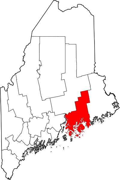
File:Map of Maine highlighting Hancock County.svg


Page contents not supported in other languages.  


File
Talk


Read
View on Commons


Tools


Actions  


Read
View on Commons


General  


What links here
Upload file
Special pages
Printable version
Page information
Get shortened URL
Download QR code


Appearance


This is a file from the Wikimedia Commons

From Wikipedia, the free encyclopedia


File

File history

File usage

Global file usage

Metadata
File:Map of Maine highlighting Hancock County.svg
Size of this PNG preview of this SVG file: 400 × 600 pixels. Other resolutions: 160 × 240 pixels | 320 × 480 pixels | 512 × 768 pixels | 683 × 1,024 pixels | 1,366 × 2,048 pixels | 723 × 1,084 pixels.

Original file(SVG file, nominally 723 × 1,084 pixels, file size: 71 KB)


Summary

Description
English: This is a locator map showing Hancock County in Maine. For more information, see Commons:United States county locator maps.
Date
Source Own work:
English: The maps use data from nationalatlas.gov, specifically countyp020.tar.gz on the Raw Data Download page. The maps also use state outline data from statesp020.tar.gz. The Florida maps use hydrogm020.tar.gz to display Lake Okeechobee.
Author David Benbennick

Licensing

Public domain I, the copyright holder of this work, release this work into the public domain. This applies worldwide.
In some countries this may not be legally possible; if so:
I grant anyone the right to use this work for any purpose, without any conditions, unless such conditions are required by law.

Captions

Add a one-line explanation of what this file represents

Items portrayed in this file

depicts

some value

12 February 2006

image/svg+xml

File history


Click on a date/time to view the file as it appeared at that time.
Date/TimeThumbnailDimensionsUserComment
current21:32, 24 June 2024Thumbnail for version as of 21:32, 24 June 2024723 × 1,084 (71 KB)Nuxfix rendering (remove clipping)
12:47, 12 February 2006Thumbnail for version as of 12:47, 12 February 20063,252 × 4,876 (131 KB)David Benbennick{{subst:User:Dbenbenn/clm|county=Hancock County|state=Maine|type=county}}


The following pages on the English Wikipedia use this file (pages on other projects are not listed):

Amherst, Maine

Aurora, Maine

Bar Harbor, Maine

Bar Harbor (CDP), Maine

Bass Harbor, Maine

Birch Harbor, Maine

Blue Hill, Maine

Blue Hill (CDP), Maine

Brooklin, Maine

Brooksville, Maine

Bucksport, Maine

Bucksport (CDP), Maine

Castine, Maine

Castine (CDP), Maine

Central Hancock, Maine

Cranberry Isles, Maine

Dedham, Maine

Deer Isle, Maine

East Blue Hill, Maine

East Hancock, Maine

East Orland, Maine

Eastbrook, Maine

Ellsworth, Maine

Franklin, Maine

Frenchboro, Maine

Gouldsboro, Maine

Great Pond, Maine

Hancock, Maine

Hancock County, Maine

Harborside, Maine

Islesford, Maine

Lamoine, Maine

List of counties in Maine

Mariaville, Maine

Marshall Island, Maine

Minturn, Maine

Mount Desert, Maine

National Register of Historic Places listings in Hancock County, Maine

Naval Security Group Activity, Winter Harbor

Northeast Harbor, Maine

Northwest Hancock, Maine

Orland, Maine

Osborn, Maine

Otis, Maine

Penobscot, Maine

Prospect Harbor, Maine

Salsbury Cove, Maine

Sargentville, Maine

Sedgwick, Maine

Somesville, Maine

Sorrento, Maine

Southwest Harbor, Maine

Southwest Harbor (CDP), Maine

Stonington, Maine

Sullivan, Maine

Sunset, Maine

Surry, Maine

Swan's Island, Maine

Tremont, Maine

Trenton, Maine

Verona Island, Maine

Waltham, Maine

Winter Harbor, Maine

Winter Harbor (CDP), Maine

User:AridCeption/sandbox

User:Nyttend/County templates/ME

File talk:Map of Maine highlighting Hancock County.svg

Template:Hancock County, Maine

Category:Populated places in Hancock County, Maine

Draft:List of counties in New England


Global file usage


The following other wikis use this file:

Usage on ar.wikipedia.org

قائمة مقاطعات مين

مقاطعة هانكوك (مين)


Usage on bar.wikipedia.org

Hancock County, Maine


Usage on be.wikipedia.org

Ханкок (акруга, Мэн)

Спіс акруг Мэна


Usage on bg.wikipedia.org

Ханкок (окръг, Мейн)


Usage on bpy.wikipedia.org

 ি, 


Usage on ca.wikipedia.org

Amherst (Maine)

Aurora (Maine)

Bar Harbor

Blue Hill (Maine)

Brooklin

Brooksville (Maine)

Bucksport (Maine)

Castine (Maine)

Cranberry Isles

Dedham (Maine)

Deer Isle

Eastbrook

Franklin (Maine)

Frenchboro

Gouldsboro

Great Pond

Hancock (Maine)

Lamoine

Mariaville

Mount Desert

Orland (Maine)

Osborn (Maine)

Otis (Maine)

Sedgwick (Maine)

Sorrento (Maine)

Southwest Harbor

Stonington (Maine)

Sullivan (Maine)

Surry (Maine)

Swan's Island

Tremont (Maine)

Trenton (Maine)

Verona Island

Waltham (Maine)

Winter Harbor

Plantilla:Comtat de Hancock (Maine)


Usage on cdo.wikipedia.org

Hancock Gông (Maine)


Usage on ceb.wikipedia.org

Hancock County (kondado sa Tinipong Bansa, Maine)


Usage on ce.wikipedia.org

Хэнкок (гуо, Мэн)


Usage on cy.wikipedia.org

Hancock County, Maine

Rhestr o Siroedd Maine


Usage on de.wikipedia.org

Bar Harbor

Hancock County (Maine)


View more global usage of this file.

Metadata

If the file has been modified from its original state, some details may not fully reflect the modified file.


Retrieved from "https://en.wikipedia.org/wiki/File:Map_of_Maine_highlighting_Hancock_County.svg"


Privacy policy

About Wikipedia

Disclaimers

Contact Wikipedia

Code of Conduct

Developers

Statistics

Cookie statement

Mobile view


Wikimedia Foundation
Powered by MediaWiki