Jump to content


Main menu


Navigation  


Main page
Contents
Current events
Random article
About Wikipedia
Contact us
Donate


Contribute  


Help
Learn to edit
Community portal
Recent changes
Upload file


Search  


Create account

Log in


Create account
 Log in


Pages for logged out editors learn more  


Contributions
Talk


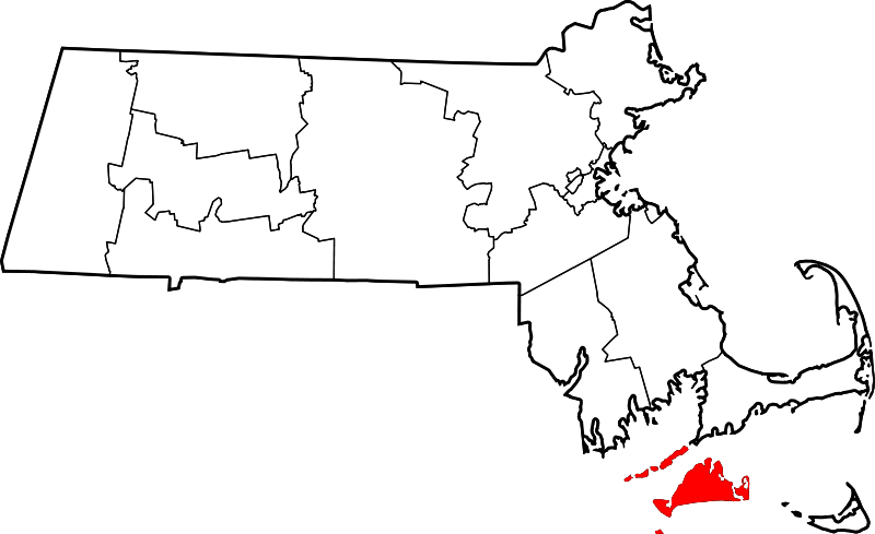
File:Map of Massachusetts highlighting Dukes County.svg


Page contents not supported in other languages.  


File
Talk


Read
View on Commons


Tools


Actions  


Read
View on Commons


General  


What links here
Upload file
Special pages
Printable version
Page information
Get shortened URL
Download QR code


Appearance


This is a file from the Wikimedia Commons

From Wikipedia, the free encyclopedia


File

File history

File usage

Global file usage

Metadata
File:Map of Massachusetts highlighting Dukes County.svg
Size of this PNG preview of this SVG file: 800 × 489 pixels. Other resolutions: 320 × 196 pixels | 640 × 391 pixels | 1,024 × 626 pixels | 1,280 × 783 pixels | 2,560 × 1,566 pixels | 1,488 × 910 pixels.

Original file(SVG file, nominally 1,488 × 910 pixels, file size: 26 KB)


Summary

Description
English: This is a locator map showing Dukes County in Massachusetts. For more information, see Commons:United States county locator maps.
Date
Source Own work:
English: The maps use data from nationalatlas.gov, specifically countyp020.tar.gz on the Raw Data Download page. The maps also use state outline data from statesp020.tar.gz. The Florida maps use hydrogm020.tar.gz to display Lake Okeechobee.
Author David Benbennick

Licensing

Public domain I, the copyright holder of this work, release this work into the public domain. This applies worldwide.
In some countries this may not be legally possible; if so:
I grant anyone the right to use this work for any purpose, without any conditions, unless such conditions are required by law.

Captions

Add a one-line explanation of what this file represents

In dieser Datei abgebildete Objekte

depicts

Einige Werte ohne einen Wikidata-Eintrag

12 February 2006

image/svg+xml

File history


Click on a date/time to view the file as it appeared at that time.
Date/TimeThumbnailDimensionsUserComment
current21:43, 24 June 2024Thumbnail for version as of 21:43, 24 June 20241,488 × 910 (26 KB)Nuxfix rendering (remove clipping)
12:49, 12 February 2006Thumbnail for version as of 12:49, 12 February 20062,976 × 1,819 (43 KB)David Benbennick{{subst:User:Dbenbenn/clm|county=Dukes County|state=Massachusetts|type=county}}


The following pages on the English Wikipedia use this file (pages on other projects are not listed):

Aquinnah, Massachusetts

Bull Island (Dukes County, Massachusetts)

Cedar Island (Dukes County, Massachusetts)

Chilmark, Massachusetts

Cuttyhunk Island

Dukes County, Massachusetts

Dukes County, Province of New York

East Chop

Edgartown, Massachusetts

Edgartown (CDP), Massachusetts

Goat Rocks (Massachusetts)

Gosnold, Massachusetts

Gull Island (Massachusetts)

Harthaven, Massachusetts

Lambert's Cove Beach

List of counties in Massachusetts

Long Point Wildlife Refuge

Makonikey

Martha's Vineyard AVA

Massachusetts House of Representatives' Barnstable, Dukes and Nantucket district

Massachusetts Senate's Cape and Islands district

Menemsha, Massachusetts

Menemsha Hills and The Brickyard

Monohansett Island

National Register of Historic Places listings in Dukes County, Massachusetts

Oak Bluffs, Massachusetts

Oak Bluffs (CDP), Massachusetts

Oyster Pond (Martha's Vineyard)

Squibnocket Pond

Stonewall Pond

Tashmoo Hill

Tisbury, Massachusetts

Tisbury Great Pond

Uncatena Island

Veckatimest Island

Vineyard Haven, Massachusetts

Wampanoag Tribe of Gay Head

Weepecket Islands

West Chop

West Tisbury, Massachusetts

User:AridCeption/sandbox

User:Nyttend/County templates/MA

Template:DukesCountyMA-geo-stub

Template:Dukes County, Massachusetts

Category:Populated places in Dukes County, Massachusetts


Global file usage


The following other wikis use this file:

Usage on ar.wikipedia.org

مقاطعة دوكس (ماساتشوستس)

تشيلمارك (ماساتشوستس)

إدغارتاون (ماساتشوستس)

غوسنولد (ماساتشوستس)

أوك بلوفس (ماساتشوستس)

قائمة مقاطعات ماساتشوستس

فينيارد هافن (ماساتشوستس)

قالب:مقاطعة دوكس (ماساتشوستس)


Usage on bar.wikipedia.org

Dukes County, Massachusetts


Usage on bg.wikipedia.org

Дюкс (окръг, Масачузетс)


Usage on bpy.wikipedia.org

 ি, 


Usage on ca.wikipedia.org

Aquinnah

Chilmark

Edgartown

Gosnold

Oak Bluffs

Tisbury (Massachusetts)

West Tisbury

Plantilla:Comtat de Dukes


Usage on cdo.wikipedia.org

Dukes Gông (Massachusetts)


Usage on ceb.wikipedia.org

Dukes County


Usage on ce.wikipedia.org

Дьюкс (гуо, Массачусетс)


Usage on cy.wikipedia.org

Dukes County, Massachusetts

Rhestr o Siroedd Massachusetts


Usage on da.wikipedia.org

Bruger:Orwell123/Minnesota Lake

Dukes County


Usage on de.wikipedia.org

Dukes County

Cape Poge Light

Cape Poge Wildlife Refuge

Long Point Wildlife Refuge

Menemsha Hills

Mytoi

Vorlage:Navigationsleiste Schutzgebiete der Trustees of Reservations im Dukes County

Norton Point Beach

Wasque

Liste der Einträge im National Register of Historic Places im Dukes County

Vorlage:Navigationsleiste Orte im Dukes County


Usage on es.wikipedia.org

Martha's Vineyard

Anexo:Condados de Massachusetts

Condado de Dukes

Categoría:Condado de Dukes


Usage on eu.wikipedia.org

Dukes konderria (Massachusetts)


Usage on fa.wikipedia.org

آکوینا، ماساچوست

شیلمارک، ماساچوست

ادگارتون، ماساچوست

گوسنولد، ماساچوست

اوک بلوفز، ماساچوست

تیسبری، ماساچوست

تیسبری غربی، ماساچوست

فهرست شهرستانهای ماساچوست


View more global usage of this file.

Metadata

If the file has been modified from its original state, some details may not fully reflect the modified file.


Retrieved from "https://en.wikipedia.org/wiki/File:Map_of_Massachusetts_highlighting_Dukes_County.svg"


Privacy policy

About Wikipedia

Disclaimers

Contact Wikipedia

Code of Conduct

Developers

Statistics

Cookie statement

Mobile view


Wikimedia Foundation
Powered by MediaWiki