Jump to content


Main menu


Navigation  


Main page
Contents
Current events
Random article
About Wikipedia
Contact us
Donate


Contribute  


Help
Learn to edit
Community portal
Recent changes
Upload file


Search  


Create account

Log in


Create account
 Log in


Pages for logged out editors learn more  


Contributions
Talk


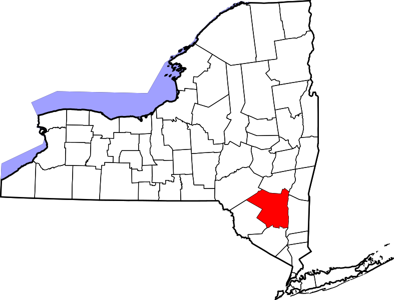
File:Map of New York highlighting Ulster County.svg


Page contents not supported in other languages.  


File
Talk


Read
View on Commons


Tools


Actions  


Read
View on Commons


General  


What links here
Upload file
Special pages
Printable version
Page information
Get shortened URL
Download QR code


Appearance


This is a file from the Wikimedia Commons

From Wikipedia, the free encyclopedia


File

File history

File usage

Global file usage

Metadata
File:Map of New York highlighting Ulster County.svg
Size of this PNG preview of this SVG file: 787 × 600 pixels. Other resolutions: 315 × 240 pixels | 630 × 480 pixels | 1,008 × 768 pixels | 1,280 × 975 pixels | 2,560 × 1,950 pixels | 1,100 × 838 pixels.

Original file(SVG file, nominally 1,100 × 838 pixels, file size: 66 KB)


Summary

Description
English: This is a locator map showing Ulster County in New York. For more information, see Commons:United States county locator maps.
Date
Source Own work:
English: The maps use data from nationalatlas.gov, specifically countyp020.tar.gz on the Raw Data Download page. The maps also use state outline data from statesp020.tar.gz. The Florida maps use hydrogm020.tar.gz to display Lake Okeechobee.
Author David Benbennick

Licensing

Public domain I, the copyright holder of this work, release this work into the public domain. This applies worldwide.
In some countries this may not be legally possible; if so:
I grant anyone the right to use this work for any purpose, without any conditions, unless such conditions are required by law.

Captions

Add a one-line explanation of what this file represents

Items portrayed in this file

depicts

some value

12 February 2006

image/svg+xml

68,086 byte

838 pixel

1,100 pixel

c40a967e3e79367186bba4e7d31305e58583f15d

File history


Click on a date/time to view the file as it appeared at that time.
Date/TimeThumbnailDimensionsUserComment
current15:29, 25 June 2024Thumbnail for version as of 15:29, 25 June 20241,100 × 838 (66 KB)Nuxuniform colors with good contrast
21:01, 15 June 2024Thumbnail for version as of 21:01, 15 June 20241,650 × 1,257 (66 KB)Nuxfix (remove clip-path)
15:34, 12 February 2006Thumbnail for version as of 15:34, 12 February 20066,599 × 5,030 (112 KB)David Benbennick{{subst:User:Dbenbenn/clm|county=Ulster County|state=New York|type=county}}


More than 100 pages use this file. The following list shows the first 100 pages that use this file only. A full list is available.

Accord, New York

Ashokan High Point

Balsam Cap

Bearsville, New York

Beaverkill Creek

Big Indian, New York

Boiceville, New York

Bristol Beach State Park

Brown's Station, New York

Centerville, Ulster County, New York

Chichester, New York

Clintondale, New York

Cornell Mountain

Cottekill, New York

Cragsmoor, New York

Denning, New York

Doubletop Mountain (New York)

Dwaar Kill (Shawangunk Kill tributary)

Dwaarkill, New York

Eagle Mountain (Ulster County, New York)

East Kingston, New York

Ellenville, New York

Esopus, New York

Fir Mountain (New York)

Friday Mountain

Gardiner, New York

Gardiner (CDP), New York

Glasco, New York

Great Vlaie

Hardenburgh, New York

High Falls, New York

Highland, Ulster County, New York

Hillside, New York

Hurley, New York

Hurley (CDP), New York

Kaatskill Kaleidoscope

Kerhonkson, New York

Kingston, New York

Kingston (town), New York

Krumville, New York

Lake Katrine, New York

Lake Maratanza

Lew Beach, New York

Lincoln Park, New York

List of counties in New York

Lloyd, New York

Lone Mountain (New York)

Malden, New York

Marbletown, New York

Marlboro, New York

Marlborough, New York

Milton, Ulster County, New York

Modena, New York

Mount Pleasant, Ulster County, New York

Mount Tremper, New York

Napanoch, New York

National Register of Historic Places listings in Ulster County, New York

New Paltz, New York

New Paltz (village), New York

Olive, New York

Olivebridge, New York

Oliverea, New York

Palentown, New York

Peekamoose Mountain

Phoenicia, New York

Pine Hill, New York

Plattekill, New York

Plattekill (CDP), New York

Port Ewen, New York

Rifton, New York

Rochester, Ulster County, New York

Rocky Mountain (Ulster County, New York)

Rondout, New York

Rosendale, New York

Rosendale (CDP), New York

Saugerties South, New York

Seager, New York

Shady, New York

Shandaken, New York

Shawangunk, New York

Shokan, New York

Spring Glen, New York

Stone Ridge, New York

Sturgeon Pool

Sundown, New York

Table Mountain (New York)

Tillson, New York

Ulster, New York

Ulster County, New York

Verkeerder Kill Falls

Walker Valley, New York

Wallkill, Ulster County, New York

Wawarsing, New York

West Hurley, New York

West Park, New York

West Saugerties, New York

Wittenberg Mountain

Zena, New York

User:Nyttend/County templates/NY/2

Template:UlsterCountyNY-geo-stub


View more links to this file.

Global file usage


The following other wikis use this file:

Usage on ar.wikipedia.org

مقاطعة أولستر (نيويورك)

كينغستون (نيويورك)

إيلنفيل (نيويورك)

قرية نيو بالتز (نيويورك)

قرية ساجرتيس (نيويورك)

دنينغ (نيويورك)

إيسبوس (نيويورك)

غاردنير (نيويورك)

هاردينبورغ (نيويورك)

هارلي

كينغستون (مقاطعة أولستر)

لويد (نيويورك)

ماربلتاون (نيويورك)

مارلبورو (نيويورك)

نيو بالتز (نيويورك)

أوليف (نيويورك)

زينا (نيويورك)

ووكر فالي (نيويورك)

غاردينر (نيويورك)

لينكولن بارك (نيويورك)

وودستوك (نيويورك)

بورت إيوين (نيويورك)

هاي فولز (نيويورك)

إيست كينغستون (نيويورك)

هيرلي (نيويورك)

ويست هيرلي (نيويورك)

لاك كاترين (نيويورك)

هيلسايد (نيويورك)

ستون ريدج (نيويورك)

قالب:مقاطعة أولستر (نيويورك)

تيلسون (نيويورك)

شوكان (نيويورك)

أسكورد (نيويورك)

بلاتيكيل (نيويورك)

ساجرتيس


Usage on azb.wikipedia.org

اولستر بؤلگهسی، نیویورک


Usage on bar.wikipedia.org

Ulster County, New York


Usage on bg.wikipedia.org

Ълстър (окръг, Ню Йорк)


Usage on bpy.wikipedia.org

 ি, ি 


Usage on ca.wikipedia.org

Accord (Nova York)

Clintondale (Nova York)

Cragsmoor (Nova York)

East Kingston (Nova York)

Ellenville (Wawarsing, Nova York)

Gardiner (Nova York, lloc designat pel cens)

Glasco (Nova York)

High Falls (Nova York)

Highland (Nova York)

Hillside (Nova York)

Hurley (Nova York, lloc designat pel cens)


View more global usage of this file.

Metadata

If the file has been modified from its original state, some details may not fully reflect the modified file.


Retrieved from "https://en.wikipedia.org/wiki/File:Map_of_New_York_highlighting_Ulster_County.svg"


Privacy policy

About Wikipedia

Disclaimers

Contact Wikipedia

Code of Conduct

Developers

Statistics

Cookie statement

Mobile view


Wikimedia Foundation
Powered by MediaWiki