Jump to content


Main menu


Navigation  


Main page
Contents
Current events
Random article
About Wikipedia
Contact us
Donate


Contribute  


Help
Learn to edit
Community portal
Recent changes
Upload file


Search  


Create account

Log in


Create account
 Log in


Pages for logged out editors learn more  


Contributions
Talk


File:Map of USA ID.svg


Page contents not supported in other languages.  


File
Talk


Read
View on Commons


Tools


Actions  


Read
View on Commons


General  


What links here
Upload file
Special pages
Printable version
Page information
Get shortened URL
Download QR code


Appearance


This is a file from the Wikimedia Commons

From Wikipedia, the free encyclopedia


File

File history

File usage

Global file usage
File:Map of USA ID.svg
Size of this PNG preview of this SVG file: 286 × 186 pixels. Other resolutions: 320 × 208 pixels | 640 × 416 pixels | 1,024 × 666 pixels | 1,280 × 832 pixels | 2,560 × 1,665 pixels.

Original file(SVG file, nominally 286 × 186 pixels, file size: 167 KB)


Clickable version

AlabamaAlaskaArizonaArkansasCaliforniaColoradoConnecticutDelawareFloridaGeorgiaHawaiiIdahoIllinoisIndianaIowaKansasKentuckyLouisianaMaineMarylandMassachusettsMichiganMinnesotaMississippiMontanaMissouriNebraskaNevadaNew HampshireNew JerseyNew MexicoNew YorkNorth CarolinaNorth DakotaOhioOklahomaOregonPennsylvaniaRhode IslandSouth CarolinaSouth DakotaTennesseeTexasUtahVermontVirginiaWashingtonWest VirginiaWisconsinWyoming
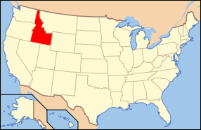
Description Map of USA with Idaho highlighted
Date see file history below.
Source own work by uploader, based on Image:Map of USA without state names.svg
Author This version: uploader
Base versions this one is derived from: originally created by en:User:Wapcaplet
Permission
(Reusing this file)
w:en:Creative Commons
attribution share alike
This file is licensed under the Creative Commons Attribution-Share Alike 3.0 Unported license. Subject to disclaimers.
You are free:
  • to share – to copy, distribute and transmit the work
  • to remix – to adapt the work
Under the following conditions:
  • attribution – You must give appropriate credit, provide a link to the license, and indicate if changes were made. You may do so in any reasonable manner, but not in any way that suggests the licensor endorses you or your use.
  • share alike – If you remix, transform, or build upon the material, you must distribute your contributions under the same or compatible license as the original.
This licensing tag was added to this file as part of the GFDL licensing update.
GNU head Permission is granted to copy, distribute and/or modify this document under the terms of the GNU Free Documentation License, Version 1.2 or any later version published by the Free Software Foundation; with no Invariant Sections, no Front-Cover Texts, and no Back-Cover Texts. A copy of the license is included in the section entitled GNU Free Documentation License. Subject to disclaimers.
w:en:Creative Commons
attribution
This file is licensed under the Creative Commons Attribution 2.0 Generic license.
You are free:
  • to share – to copy, distribute and transmit the work
  • to remix – to adapt the work
  • Under the following conditions:
    • attribution – You must give appropriate credit, provide a link to the license, and indicate if changes were made. You may do so in any reasonable manner, but not in any way that suggests the licensor endorses you or your use.
    Other versions image:Map of USA with state names.svg
    138
    45
    43
    286
    186

    Alaska

    Captions

    Add a one-line explanation of what this file represents

    Items portrayed in this file

    depicts

    File history


    Click on a date/time to view the file as it appeared at that time.
    Date/TimeThumbnailDimensionsUserComment
    current06:26, 9 June 2006Thumbnail for version as of 06:26, 9 June 2006286 × 186 (167 KB)Huebi~commonswiki{{Information| |Description=Map of USA with Idaho highlighted |other_versions=image:Map of USA with state names.svg }} Category:Maps of the United States Category:Maps of Idaho Category:SVG maps {{GFDL-en}}{{cc-by-2.0}}{{cc-by-sa-1.0}}{


    More than 100 pages use this file. The following list shows the first 100 pages that use this file only. A full list is available.

    Ada County, Idaho

    Adams County, Idaho

    Adams County Courthouse (Idaho)

    Albion Methodist Church

    Allton Building

    Arco Baptist Community Church

    Bannock County, Idaho

    Benewah County Courthouse

    Boise High School

    Canyonside School

    Carl Blessing Outbuildings

    Co-op Block and J. N. Ireland Bank

    Council Ranger Station

    Dick Callen House

    Empire School (Rupert, Idaho)

    Frank J. Brick House

    Gun laws in Idaho

    Hollingshead Homestead

    Hotel Patrie

    Index of Idaho-related articles

    Jacob Spori Building

    James Bothwell Water Tank House

    James F. Bridwell House

    Jefferson County Courthouse (Idaho)

    Jerome County Courthouse

    Jerome First Baptist Church

    John Skillern House

    Josiah Scott House

    Kimberly High School (Kimberly, Idaho)

    Kootenai Inn

    LGBT rights in Idaho

    List of state and territory name etymologies of the United States

    Madison County Courthouse (Idaho)

    Malad Second Ward Tabernacle

    Meadows Schoolhouse

    National Register of Historic Places listings in Ada County, Idaho

    National Register of Historic Places listings in Adams County, Idaho

    National Register of Historic Places listings in Bannock County, Idaho

    National Register of Historic Places listings in Bear Lake County, Idaho

    National Register of Historic Places listings in Benewah County, Idaho

    National Register of Historic Places listings in Bingham County, Idaho

    National Register of Historic Places listings in Blaine County, Idaho

    National Register of Historic Places listings in Boise County, Idaho

    National Register of Historic Places listings in Bonner County, Idaho

    National Register of Historic Places listings in Bonneville County, Idaho

    National Register of Historic Places listings in Boundary County, Idaho

    National Register of Historic Places listings in Butte County, Idaho

    National Register of Historic Places listings in Camas County, Idaho

    National Register of Historic Places listings in Canyon County, Idaho

    National Register of Historic Places listings in Caribou County, Idaho

    National Register of Historic Places listings in Cassia County, Idaho

    National Register of Historic Places listings in Clark County, Idaho

    National Register of Historic Places listings in Clearwater County, Idaho

    National Register of Historic Places listings in Custer County, Idaho

    National Register of Historic Places listings in Elmore County, Idaho

    National Register of Historic Places listings in Franklin County, Idaho

    National Register of Historic Places listings in Fremont County, Idaho

    National Register of Historic Places listings in Gem County, Idaho

    National Register of Historic Places listings in Gooding County, Idaho

    National Register of Historic Places listings in Idaho

    National Register of Historic Places listings in Idaho County, Idaho

    National Register of Historic Places listings in Jefferson County, Idaho

    National Register of Historic Places listings in Jerome County, Idaho

    National Register of Historic Places listings in Kootenai County, Idaho

    National Register of Historic Places listings in Latah County, Idaho

    National Register of Historic Places listings in Lemhi County, Idaho

    National Register of Historic Places listings in Lewis County, Idaho

    National Register of Historic Places listings in Lincoln County, Idaho

    National Register of Historic Places listings in Madison County, Idaho

    National Register of Historic Places listings in Minidoka County, Idaho

    National Register of Historic Places listings in Nez Perce County, Idaho

    National Register of Historic Places listings in Oneida County, Idaho

    National Register of Historic Places listings in Owyhee County, Idaho

    National Register of Historic Places listings in Payette County, Idaho

    National Register of Historic Places listings in Power County, Idaho

    National Register of Historic Places listings in Shoshone County, Idaho

    National Register of Historic Places listings in Teton County, Idaho

    National Register of Historic Places listings in Twin Falls County, Idaho

    National Register of Historic Places listings in Valley County, Idaho

    National Register of Historic Places listings in Washington County, Idaho

    New Meadows station

    Outline of Idaho

    Rexburg Stake Tabernacle

    Ririe A Pegram Truss Railroad Bridge

    Ririe B Pegram Truss Railroad Bridge

    Sandpoint High School

    St. Joseph's Mission (Culdesac, Idaho)

    St. Maries Masonic Temple No. 63

    State Bank of Kamiah

    Teton County Courthouse (Idaho)

    Tom Barnes Barn

    United Presbyterian Church (Malad City, Idaho)

    United States District Court for the District of Idaho

    Upper Brownlee School

    Victor station (Idaho)

    User:Sesh/Democratic Party Presidential Primaries 2008

    Wikipedia:WikiProject Idaho

    Template:NRHP in Idaho by county

    Category:Idaho

    Category:Images of Idaho


    View more links to this file.

    Global file usage


    The following other wikis use this file:

    Usage on af.wikipedia.org

    Idaho

    Deelstate van die Verenigde State van Amerika


    Usage on ang.wikipedia.org

    Flocc:Idaho


    Usage on an.wikipedia.org

    Idaho


    Usage on arc.wikipedia.org

    ܐܝܕܐܗܘ


    Usage on arz.wikipedia.org

    ايداهو


    Usage on ay.wikipedia.org

    Idaho suyu


    Usage on bar.wikipedia.org

    Listn vo de Bundesstootn


    Usage on bat-smg.wikipedia.org

    Aidahs


    Usage on ba.wikipedia.org

    Айдахо


    Usage on bcl.wikipedia.org

    Idaho


    Usage on be-tarask.wikipedia.org

    Айдага


    Usage on bg.wikipedia.org

    Ейда

    Адамс (окръг, Айдахо)

    Айдахо (окръг)

    Банок (окръг)

    Баундари

    Бенъуа

    Беър Лейк (окръг)

    Бингам (окръг)

    Блейн (окръг, Айдахо)

    Бойзи (окръг)

    Бонвил

    Бонър

    Бют (окръг, Айдахо)

    Вали (окръг, Айдахо)

    Гудинг (окръг)

    Джем (окръг)

    Джеръм (окръг)

    Джеферсън (окръг, Айдахо)

    Елмор (окръг, Айдахо)

    Камас (окръг)

    Карибу (окръг)

    Каша (окръг)

    Кениън

    Кларк (окръг, Айдахо)

    Клиъруотър (окръг, Айдахо)

    Кутенаи (окръг)

    Къстър (окръг, Айдахо)

    Лата (окръг)

    Лими

    Линкълн (окръг, Айдахо)

    Луис (окръг, Айдахо)

    Мадисън (окръг, Айдахо)

    Минидока (окръг)

    Нез Пърс (окръг)

    Онайда (окръг, Айдахо)

    Оуайхи (окръг)

    Пайет (окръг)

    Пауър


    View more global usage of this file.

    Retrieved from "https://en.wikipedia.org/wiki/File:Map_of_USA_ID.svg"


    Privacy policy

    About Wikipedia

    Disclaimers

    Contact Wikipedia

    Code of Conduct

    Developers

    Statistics

    Cookie statement

    Mobile view


    Wikimedia Foundation
    Powered by MediaWiki