Jump to content


Main menu


Navigation  


Main page
Contents
Current events
Random article
About Wikipedia
Contact us
Donate


Contribute  


Help
Learn to edit
Community portal
Recent changes
Upload file


Search  


Create account

Log in


Create account
 Log in


Pages for logged out editors learn more  


Contributions
Talk


File:Map of USA TX.svg


Page contents not supported in other languages.  


File
Talk


Read
View on Commons


Tools


Actions  


Read
View on Commons


General  


What links here
Upload file
Special pages
Printable version
Page information
Get shortened URL
Download QR code


Appearance


This is a file from the Wikimedia Commons

From Wikipedia, the free encyclopedia


File

File history

File usage

Global file usage

Metadata
File:Map of USA TX.svg
Size of this PNG preview of this SVG file: 286 × 186 pixels. Other resolutions: 320 × 208 pixels | 640 × 416 pixels | 1,024 × 666 pixels | 1,280 × 832 pixels | 2,560 × 1,665 pixels.

Original file(SVG file, nominally 286 × 186 pixels, file size: 167 KB)


Clickable version

AlabamaAlaskaArizonaArkansasCaliforniaColoradoConnecticutDelawareFloridaGeorgiaHawaiiIdahoIllinoisIndianaIowaKansasKentuckyLouisianaMaineMarylandMassachusettsMichiganMinnesotaMississippiMontanaMissouriNebraskaNevadaNew HampshireNew JerseyNew MexicoNew YorkNorth CarolinaNorth DakotaOhioOklahomaOregonPennsylvaniaRhode IslandSouth CarolinaSouth DakotaTennesseeTexasUtahVermontVirginiaWashingtonWest VirginiaWisconsinWyoming
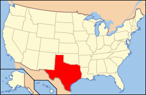
Description Map of USA with Texas highlighted
Date see file history below.
Source own work by uploader, based on Image:Map of USA without state names.svg
Author This version: uploader
Base versions this one is derived from: originally created by en:User:Wapcaplet
Permission
(Reusing this file)
w:en:Creative Commons
attribution share alike
This file is licensed under the Creative Commons Attribution-Share Alike 3.0 Unported license. Subject to disclaimers.
You are free:
  • to share – to copy, distribute and transmit the work
  • to remix – to adapt the work
Under the following conditions:
  • attribution – You must give appropriate credit, provide a link to the license, and indicate if changes were made. You may do so in any reasonable manner, but not in any way that suggests the licensor endorses you or your use.
  • share alike – If you remix, transform, or build upon the material, you must distribute your contributions under the same or compatible license as the original.
This licensing tag was added to this file as part of the GFDL licensing update.
GNU head Permission is granted to copy, distribute and/or modify this document under the terms of the GNU Free Documentation License, Version 1.2 or any later version published by the Free Software Foundation; with no Invariant Sections, no Front-Cover Texts, and no Back-Cover Texts. A copy of the license is included in the section entitled GNU Free Documentation License. Subject to disclaimers.
w:en:Creative Commons
attribution
This file is licensed under the Creative Commons Attribution 2.0 Generic license.
You are free:
  • to share – to copy, distribute and transmit the work
  • to remix – to adapt the work
  • Under the following conditions:
    • attribution – You must give appropriate credit, provide a link to the license, and indicate if changes were made. You may do so in any reasonable manner, but not in any way that suggests the licensor endorses you or your use.
    Other versions image:Map of USA with state names.svg

    Captions

    Add a one-line explanation of what this file represents

    Items portrayed in this file

    depicts

    File history


    Click on a date/time to view the file as it appeared at that time.
    Date/TimeThumbnailDimensionsUserComment
    current10:36, 9 June 2006Thumbnail for version as of 10:36, 9 June 2006286 × 186 (167 KB)Huebi~commonswiki{{Information| |Description=Map of USA with Texas highlighted |other_versions=image:Map of USA with state names.svg }} Category:Maps of the United States Category:Maps of Texas Category:SVG maps {{GFDL-en}}{{cc-by-2.0}}{{cc-by-sa-1.0}}{


    More than 100 pages use this file. The following list shows the first 100 pages that use this file only. A full list is available.

    Adolphus Hotel

    Alamo Stadium

    Alibates Flint Quarries National Monument

    Anderson, Texas

    Anson Mills Building

    Association of Texas Small School Bands

    Baker Hotel (Mineral Wells, Texas)

    Balinese Room

    Battle of Palmito Ranch

    Bishop's Palace (Galveston, Texas)

    Blinn College

    Chamizal National Memorial

    Cotton Bowl (stadium)

    Dal-Tex Building

    Dallas Arboretum and Botanical Garden

    Dallas Union Station

    Dealey Plaza

    Eisenhower Birthplace State Historic Site

    Elissa (ship)

    Enchanted Rock

    Espada Acequia

    Fair Park

    FirstBank Southwest Tower

    First Lift Station

    Fort Bliss National Cemetery

    Fort Brown

    Fort D. A. Russell (Texas)

    Fort Davis National Historic Site

    Fort Duncan

    Fort McIntosh, Texas

    Fort Sam Houston

    Fort Worth Stockyards

    Galveston Seawall

    Gillespie County, Texas

    Ginocchio Historic District

    Glenrio, New Mexico and Texas

    Gruene, New Braunfels, Texas

    Gruene Hall

    Hall of State

    Hueco Tanks

    Index of Texas-related articles

    Irving Independent School District

    Jefferson Theatre

    John Fitzgerald Kennedy Memorial

    Kilgore College

    King Ranch

    Lake Cliff, Dallas

    Languages of the United States

    List of state and territory name etymologies of the United States

    Lubbock High School

    Lubbock Lake Landmark

    Lyndon B. Johnson National Historical Park

    Magnolia Hotel (Dallas, Texas)

    MathewsPowell House

    Medina Dam

    Menger Hotel

    Mother Neff State Park

    Munger Place Historic District

    Natural Bridge Caverns

    O. T. Bassett Tower

    Old Harrison County Courthouse (Texas)

    Palo Alto Battlefield National Historical Park

    Panna Maria, Texas

    Parkland Memorial Hospital

    Plaza Hotel (El Paso, Texas)

    Point Bolivar Light

    Rainbow Bridge & Veterans Memorial Bridge (Texas)

    Regency Bridge

    Rosenberg Library

    Sam Bell Maxey House

    San Ygnacio, Texas

    Spindletop

    St. Patrick Cathedral (Fort Worth, Texas)

    Starr Family Home State Historic Site

    Strand Historic District

    Swiss Avenue Historic District

    T&P Station

    Texas Music Educators Association

    Texas School Book Depository

    Texas Theatre

    Texas and Pacific 610

    The Ginocchio

    Thurber, Texas

    TrevinoUribe Rancho

    USS Cavalla (SS-244)

    USS Hatteras (1861)

    USS Lexington (CV-16)

    USS Texas (BB-35)

    Union Depot (El Paso)

    University Interscholastic League

    W. H. Adamson High School

    Waco High School

    Waco Suspension Bridge

    West End Historic District (Dallas)

    Westphalia, Texas

    Wheatley Place, Dallas

    Will Rogers Memorial Center

    Wikipedia talk:WikiProject U.S. states/mockups

    Category:Images of Texas

    Category:Texas


    View more links to this file.

    Global file usage


    The following other wikis use this file:

    Usage on af.wikipedia.org

    Texas

    Deelstate van die Verenigde State van Amerika


    Usage on als.wikipedia.org

    Texas


    Usage on ang.wikipedia.org

    Flocc:Texas


    Usage on an.wikipedia.org

    Texas


    Usage on ay.wikipedia.org

    Texas suyu


    Usage on azb.wikipedia.org

    تکزاس ایالتی شهرلرین نۆفوسا گؤره سیرالانماسی

    ای کستیلو، تکزاس


    Usage on az.wikipedia.org

    Ərazisinə görə ABŞ-nin ştat və ərazilərinin siyahısı


    Usage on az.wiktionary.org

    Texas


    Usage on bar.wikipedia.org

    Listn vo de Bundesstootn


    Usage on bat-smg.wikipedia.org

    Teksasos


    Usage on ba.wikipedia.org

    Техас


    Usage on be-tarask.wikipedia.org

    Тэхас


    Usage on bg.wikipedia.org

    Анджелина (окръг, Тексас)

    Арансас (окръг, Тексас)

    Остин (окръг, Тексас)

    Бий (окръг, Тексас)

    Беър (окръг, Тексас)

    Бланко (окръг, Тексас)

    Бордън (окръг, Тексас)

    Боски (окръг, Тексас)

    Боуи (окръг, Тексас)

    Бразория

    Брискоу (окръг, Тексас)

    Бразос (окръг, Тексас)

    Брукс (окръг, Тексас)

    Браун (окръг, Тексас)

    Бърлсън (окръг, Тексас)

    Бърнит (окръг, Тексас)

    Колдуел (окръг, Тексас)

    Калхун (окръг, Тексас)

    Калахан (окръг, Тексас)

    Камерън (окръг, Тексас)

    Кемп (окръг, Тексас)

    Карсън (окръг, Тексас)

    Кас (окръг, Тексас)

    Кастро (окръг, Тексас)

    Чеймбърс (окръг, Тексас)

    Чероки (окръг, Тексас)

    Клей (окръг, Тексас)

    Кокран (окръг, Тексас)

    Коук (окръг)

    Колман (окръг, Тексас)

    Колин (окръг, Тексас)

    Колингсуърт (окръг, Тексас)

    Колорадо (окръг, Тексас)

    Комал (окръг, Тексас)

    Команчи (окръг, Тексас)

    Кончо (окръг, Тексас)


    View more global usage of this file.

    Metadata

    If the file has been modified from its original state, some details may not fully reflect the modified file.


    Retrieved from "https://en.wikipedia.org/wiki/File:Map_of_USA_TX.svg"


    Privacy policy

    About Wikipedia

    Disclaimers

    Contact Wikipedia

    Code of Conduct

    Developers

    Statistics

    Cookie statement

    Mobile view


    Wikimedia Foundation
    Powered by MediaWiki