Jump to content


Main menu


Navigation  


Main page
Contents
Current events
Random article
About Wikipedia
Contact us
Donate


Contribute  


Help
Learn to edit
Community portal
Recent changes
Upload file


Search  


Create account

Log in


Create account
 Log in


Pages for logged out editors learn more  


Contributions
Talk


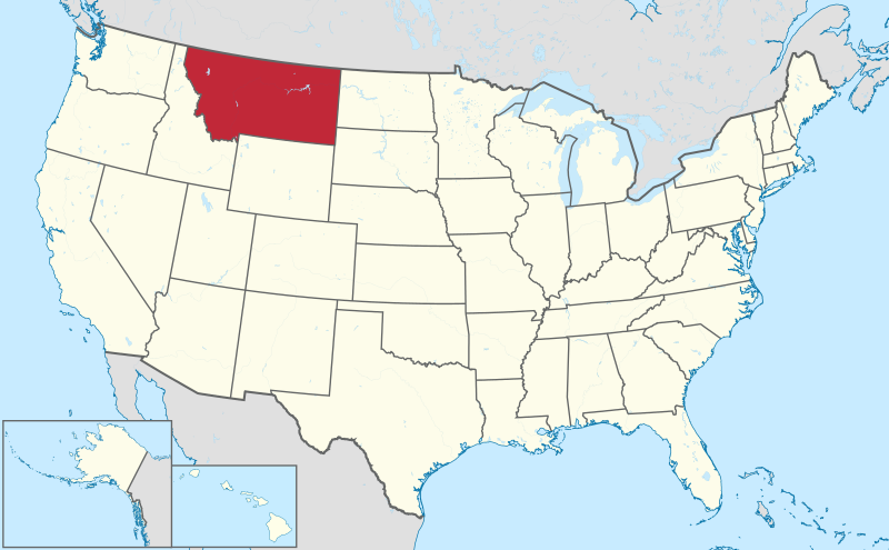
File:Montana in United States.svg


Page contents not supported in other languages.  


File
Talk


Read
View on Commons


Tools


Actions  


Read
View on Commons


General  


What links here
Upload file
Special pages
Printable version
Page information
Get shortened URL
Download QR code


Appearance


This is a file from the Wikimedia Commons

From Wikipedia, the free encyclopedia


File

File history

File usage

Global file usage

Metadata
File:Montana in United States.svg
Size of this PNG preview of this SVG file: 800 × 495 pixels. Other resolutions: 320 × 198 pixels | 640 × 396 pixels | 1,024 × 634 pixels | 1,280 × 792 pixels | 2,560 × 1,585 pixels | 1,181 × 731 pixels.

Original file(SVG file, nominally 1,181 × 731 pixels, file size: 3.46 MB)


Summary

Description
Deutsch: Lage von Montana in United States in den Vereinigten Staaten.
English: Location of state of Montana in United States in the United States
Date
Source Own work
 
This SVG locator map includes elements from this locator map:
Usa edcp location map.svg (by Uwe Dedering).
 
This SVG locator map includes elements from this locator map:
USA Hawaii location map.svg (by NordNordWest).
 
This SVG locator map includes elements from this locator map:
Canada location map.svg (by Yug).
Author TUBS Gallery
Other versions

This SVG map is part of a locator map series applying the widespread location map scheme. Please see root category to browse for more.

SVG development

InfoField

 
The source code of this large SVGisinvalid due to 3 errors.
 
This oversized W3C-invalid locator map was created with Adobe Illustrator by TUBS,
 
and with Inkscape.
 
This large W3C-invalid SVG locator map was uploaded with Commonist.

 
This Adobe SVG locator map is very large because TUBS kept the superfluous Adobe PGF or other CDATA garbage
.

Licensing

I, the copyright holder of this work, hereby publish it under the following license:
w:en:Creative Commons
attribution share alike
This file is licensed under the Creative Commons Attribution-Share Alike 3.0 Unported license.
You are free:
  • to share – to copy, distribute and transmit the work
  • to remix – to adapt the work
  • Under the following conditions:
    • attribution – You must give appropriate credit, provide a link to the license, and indicate if changes were made. You may do so in any reasonable manner, but not in any way that suggests the licensor endorses you or your use.
    • share alike – If you remix, transform, or build upon the material, you must distribute your contributions under the same or compatible license as the original.
    I'd greatly appreciate, that you attribute this media file to Wikimedia Commons, if used outside Wikipedia or Commons. For use in publications such as books, newspapers, blogs, websites, please insert here the following line:
    {{published|author= |date= |url= |title= |org= }}
    and fill the applicable fields. (Example). License terms given above still apply.

    বাংলা  Deutsch  Deutsch (Sie-Form)  Ελληνικά  English  español  français  Ἀρχαία ἑλληνικὴ  Bahasa Indonesia  日本語  македонски  Nederlands  português  русский  Türkçe  简体中文  繁體中文  +/−

    Captions

    Add a one-line explanation of what this file represents

    Items portrayed in this file

    depicts

    some value

    30 July 2011

    File history


    Click on a date/time to view the file as it appeared at that time.
    Date/TimeThumbnailDimensionsUserComment
    current17:26, 30 July 2011Thumbnail for version as of 17:26, 30 July 20111,181 × 731 (3.46 MB)TUBS


    The following pages on the English Wikipedia use this file (pages on other projects are not listed):

    Beaverhead County, Montana

    Big Horn County, Montana

    Blaine County, Montana

    Broadwater County, Montana

    Carbon County, Montana

    Carter County, Montana

    Cascade County, Montana

    Chouteau County, Montana

    Custer County, Montana

    Daniels County, Montana

    Dawson County, Montana

    Deer Lodge County, Montana

    Fallon County, Montana

    Fergus County, Montana

    Flathead County, Montana

    Gallatin County, Montana

    Garfield County, Montana

    Glacier County, Montana

    Golden Valley County, Montana

    Granite County, Montana

    Hill County, Montana

    Jefferson County, Montana

    Judith Basin County, Montana

    Lake County, Montana

    Lewis and Clark County, Montana

    Liberty County, Montana

    Lincoln County, Montana

    List of Montana state symbols

    List of census-designated places in Montana

    List of first-level administrative divisions by area

    List of municipalities in Montana

    List of people from Montana

    Madison County, Montana

    McCone County, Montana

    Meagher County, Montana

    Mineral County, Montana

    Missoula County, Montana

    Montana

    Montana Department of Corrections

    Musselshell County, Montana

    Park County, Montana

    Petroleum County, Montana

    Phillips County, Montana

    Pondera County, Montana

    Powder River County, Montana

    Powell County, Montana

    Prairie County, Montana

    Ravalli County, Montana

    Richland County, Montana

    Roosevelt County, Montana

    Rosebud County, Montana

    Sanders County, Montana

    Sheridan County, Montana

    Silver Bow County, Montana

    Stillwater County, Montana

    Sweet Grass County, Montana

    Teton County, Montana

    Toole County, Montana

    Treasure County, Montana

    United States presidential elections in Montana

    Valley County, Montana

    Wheatland County, Montana

    Wibaux County, Montana

    Yellowstone County, Montana

    User:Treetoes023/List of the largest country subdivisions by area


    Global file usage


    The following other wikis use this file:

    Usage on am.wikipedia.org


    Usage on ang.wikipedia.org

    Montǣna


    Usage on ar.wikipedia.org

    مونتانا


    Usage on ary.wikipedia.org

    مونطانا


    Usage on arz.wikipedia.org

    مونتانا


    Usage on ast.wikipedia.org

    Montana


    Usage on azb.wikipedia.org

    مونتانا

    کاربون بؤلگهسی، مونتانا


    Usage on bcl.wikipedia.org

    Montana


    Usage on be-tarask.wikipedia.org

    Мантана


    Usage on be.wikipedia.org

    Мантана


    Usage on bg.wikipedia.org

    Монтана (щат)


    Usage on bs.wikipedia.org

    Montana


    Usage on ca.wikipedia.org

    Montana


    Usage on cdo.wikipedia.org

    Montana


    Usage on ceb.wikipedia.org

    Gumagamit:Lsjbot/Duplicates/Montana (estado)


    Usage on crh.wikipedia.org

    Montana


    Usage on cs.wikipedia.org

    Montana

    Seznam vlajek států Spojených států amerických

    Seznam státních fosílií amerických států

    Seznam státních písní států USA


    Usage on cy.wikipedia.org

    Montana

    Beaverhead County, Montana

    Big Horn County, Montana

    Blaine County, Montana

    Carbon County, Montana

    Carter County, Montana

    Custer County, Montana

    Dawson County, Montana

    Gallatin County, Montana

    Garfield County, Montana

    Golden Valley County, Montana

    Hill County, Montana

    Jefferson County, Montana

    Lake County, Montana

    Lewis and Clark County, Montana

    Liberty County, Montana

    Lincoln County, Montana

    Madison County, Montana

    Mineral County, Montana

    Park County, Montana

    Phillips County, Montana

    Powell County, Montana

    Prairie County, Montana

    Richland County, Montana

    Roosevelt County, Montana

    Sheridan County, Montana

    Teton County, Montana

    Valley County, Montana

    Broadwater County, Montana


    View more global usage of this file.

    Metadata

    If the file has been modified from its original state, some details may not fully reflect the modified file.


    Retrieved from "https://en.wikipedia.org/wiki/File:Montana_in_United_States.svg"


    Privacy policy

    About Wikipedia

    Disclaimers

    Contact Wikipedia

    Code of Conduct

    Developers

    Statistics

    Cookie statement

    Mobile view


    Wikimedia Foundation
    Powered by MediaWiki