Jump to content


Main menu


Navigation  


Main page
Contents
Current events
Random article
About Wikipedia
Contact us
Donate


Contribute  


Help
Learn to edit
Community portal
Recent changes
Upload file


Search  


Create account

Log in


Create account
 Log in


Pages for logged out editors learn more  


Contributions
Talk


File:Peru physical map.svg


Page contents not supported in other languages.  


File
Talk


Read
View on Commons


Tools


Actions  


Read
View on Commons


General  


What links here
Upload file
Special pages
Printable version
Page information
Get shortened URL
Download QR code


Appearance


This is a file from the Wikimedia Commons

From Wikipedia, the free encyclopedia


File

File history

File usage

Global file usage

Metadata
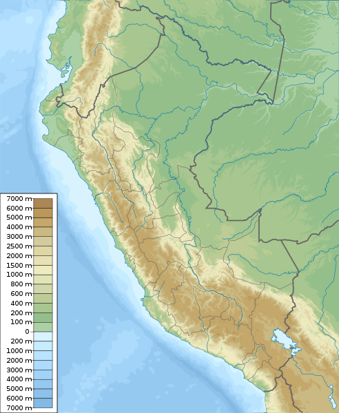
File:Peru physical map.svg
Size of this PNG preview of this SVG file: 492 × 600 pixels. Other resolutions: 197 × 240 pixels | 394 × 480 pixels | 630 × 768 pixels | 840 × 1,024 pixels | 1,681 × 2,048 pixels | 851 × 1,037 pixels.

Original file(SVG file, nominally 851 × 1,037 pixels, file size: 4.81 MB)


Summary

Description
English: Physical map of Peru, parameters are equal to File:Peru location map.svg
Español: mapa físico de Perú, los parámetros son iguales a File:Peru location map.svg
Date
Source Own work, topographical information from Shuttle Radar Topography Mission
Author Urutseg
SVG development

InfoField

 
The source code of this large SVGisvalid.
 
This oversized map was created with Adobe Illustrator,
 
and with Inkscape.
 
 This map uses embedded text that can be easily translated using a text editor.

Licensing

I, the copyright holder of this work, hereby publish it under the following license:
Creative Commons CC-Zero This file is made available under the Creative Commons CC0 1.0 Universal Public Domain Dedication.
The person who associated a work with this deed has dedicated the work to the public domain by waiving all of their rights to the work worldwide under copyright law, including all related and neighboring rights, to the extent allowed by law. You can copy, modify, distribute and perform the work, even for commercial purposes, all without asking permission.

Captions

Physical map of Peru

Elementos representados en este archivo

depicts

Algún valor sin elemento de Wikidata

5 March 2011

image/svg+xml

File history


Click on a date/time to view the file as it appeared at that time.
Date/TimeThumbnailDimensionsUserComment
current10:42, 5 March 2011Thumbnail for version as of 10:42, 5 March 2011851 × 1,037 (4.81 MB)Urutseg== Summary == {{Information |Description ={{en|1=Physical map of Peru, parameters are equal to Bolivia location map.svg}} |Source ={{own}} |Author =Urutseg |Date =2011-03-05 |Pe


More than 100 pages use this file. The following list shows the first 100 pages that use this file only. A full list is available.

1970 Ancash earthquake

2001 southern Peru earthquake

2005 Northern Peru earthquake

Acaray

Alférez FAP Alfredo Vladimir Sara Bauer Airport

Alpamayo

Alto Mayo Protection Forest

Ampato

Ampay National Sanctuary

Artesonraju

Bahuaja-Sonene National Park

Battle of Callao

Blockade of Callao

Calipuy National Reserve

Calipuy National Sanctuary

Caplina River

Caral

Cerros de Amotape National Park

Chacamarca Historic Sanctuary

Chan Chan

Chavín de Huántar

Chillón River

Chivateros

Choquequirao

Colca Canyon

Cordillera Azul National Park

Cordillera Blanca

Cordillera Huayhuash

Coricancha

Cumbemayo

Cusco

Cutervo National Park

El Angolo Game Reserve

Gran Pajatén

Gran Vilaya

Güeppi-Sekime National Park

Historic Centre of Lima

Huari (archaeological site)

Huascarán

Huascarán National Park

Huayna Picchu

Huaynaputina

Ica River

Jeberos

Junín National Reserve

Kuntur Wasi

Kuélap

Lachay National Reserve

Lagunas de Mejía National Sanctuary

Lake Conococha

Lake Junin

Lake Lauricocha

Lake Palcacocha

Lake Titicaca

Laquipampa Wildlife Refuge

Llaqtapata

Machu Picchu

Manglares de Tumbes National Sanctuary

Manu National Park

Mismi

Misti

Moray (Inca ruin)

Nanay River

Nazca lines

Pachacamac

Pagaibamba Protection Forest

Pampa Galeras  Barbara D'Achille National Reserve

Pampas de Ayacucho Historic Sanctuary

Pantanos de Villa Wildlife Refuge

Paracas National Reserve

Pikimachay

Poechos Reservoir

Pongo de Mainique

Pongo de Manseriche

Pui Pui Protection Forest

Puquio Santa Rosa Protection Forest

Revash

Rio Abiseo National Park

Rímac River

Sacred Valley

Sacsayhuamán

San MatíasSan Carlos Protection Forest

Santa River

Sarcophagi of Carajía

Sillustani

Siula Grande

Sunchubamba Game Reserve

Tabaconas Namballe National Sanctuary

Tambo Colorado

Tambopata National Reserve

Tingo María National Park

Titicaca National Reserve

Toquepala Caves

Tumbes River

Túcume

Vilcabamba, Peru

Vitcos

Wiñay Wayna

YanachagaChemillén National Park

Yanawayin Lake


View more links to this file.

Global file usage


The following other wikis use this file:

Usage on ar.wikipedia.org

قالب:خريطة مواقع بيرو

زلزال بيرو 2018

زلزال بيرو 1687

بحيرة أكشيكوتشا

زلزال تشيمبوتي 1996

زلزال أريكا 1604


Usage on ast.wikipedia.org

Módulu:Mapa de llocalización/datos/Perú

Módulu:Mapa de llocalización/datos/Perú/usu


Usage on az.wikipedia.org

Titikaka gölü

Grau dənizi

Şablon:Yer xəritəsi Peru

Uaskaran Milli Parkı

Manu Milli Parkı

Ankaş zəlzələsi (1970)

Seçura

Parakas yarımadası

Peru zəlzələsi (2018)

Amazon yağış meşələri

Gəlin şəlaləsi

Şanay-Timpişka


Usage on ban.wikipedia.org

Taman Nasional Cutérvo

Taman Nasional Huascarán

Taman Nasional Manú

Taman Nasional Rio Abiséo


Usage on bar.wikipedia.org

Vorlog:Positionskarte Peru


Usage on ba.wikipedia.org

Ҡалып:ПозКарта Перу


Usage on bcl.wikipedia.org

Janq'u Llaqa


Usage on be-tarask.wikipedia.org

Шаблён:Лякалізацыйная мапа Пэру


Usage on be.wikipedia.org

Карапуна

Уаскаран

Шаблон:На карце/Перу

Мараньён

Укаялі

Урубамба

Уальяга

Рымак

Пастаса (рака)

Уайнапуціна


Usage on bg.wikipedia.org

Куско

Трухильо (Перу)

Лима

Каляо

Арекипа

Мараньон

Кахамарка

Шаблон:ПК Перу

Мачу Пикчу

Лаурикоча

Уиняй Уайна

Титикака


View more global usage of this file.

Metadata

If the file has been modified from its original state, some details may not fully reflect the modified file.


Retrieved from "https://en.wikipedia.org/wiki/File:Peru_physical_map.svg"


Privacy policy

About Wikipedia

Disclaimers

Contact Wikipedia

Code of Conduct

Developers

Statistics

Cookie statement

Mobile view


Wikimedia Foundation
Powered by MediaWiki