Jump to content


Main menu


Navigation  


Main page
Contents
Current events
Random article
About Wikipedia
Contact us
Donate


Contribute  


Help
Learn to edit
Community portal
Recent changes
Upload file


Search  


Create account

Log in


Create account
 Log in


Pages for logged out editors learn more  


Contributions
Talk


File:Poland adm location map.svg


Page contents not supported in other languages.  


File
Talk


Read
View on Commons


Tools


Actions  


Read
View on Commons


General  


What links here
Upload file
Special pages
Printable version
Page information
Get shortened URL
Download QR code


Appearance


This is a file from the Wikimedia Commons

From Wikipedia, the free encyclopedia


File

File history

File usage

Global file usage

Metadata
File:Poland adm location map.svg
Size of this PNG preview of this SVG file: 617 × 600 pixels. Other resolutions: 247 × 240 pixels | 494 × 480 pixels | 790 × 768 pixels | 1,053 × 1,024 pixels | 2,107 × 2,048 pixels | 861 × 837 pixels.

Original file(SVG file, nominally 861 × 837 pixels, file size: 340 KB)


Summary

Description
Deutsch: Positionskarte von Polen
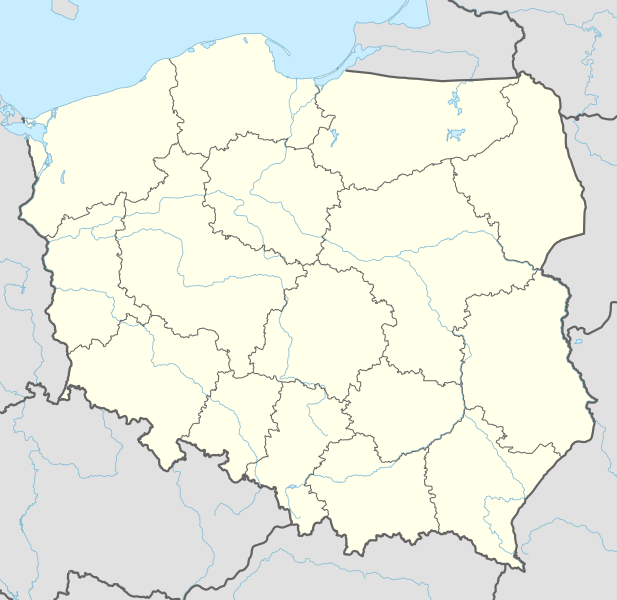
English: Location map of Poland

Equirectangular projection, vertical stretching 160 %
Border coordinates

55.2
13.8←↕→24.5
48.7
 Info This map is part of a series of location maps with unified standards: SVG as file format, standardised colours and name scheme. The boundaries on these maps always show the de facto situation and do not imply any endorsement or acceptance. In case of changes of the shown area the file is updated. The old version will be uploaded as a new file and thus is still available.
Date
Source

Own work using:

  • United States National Imagery and Mapping Agency data
  • World Data Base II data
Author NordNordWest
SVG development

InfoField

 
The SVG code is valid.
 
This locator map was created with Adobe Illustrator.

Kartenwerkstatt
This SVG map has been made or improved in the German Kartenwerkstatt (Map Lab). You can propose maps to improve as well.

azərbaycanca  čeština  Deutsch  Deutsch (Sie-Form)  English  español  français  italiano  latviešu  magyar  Nederlands  Plattdüütsch  polski  português  română  sicilianu  slovenščina  suomi  македонски  русский  ქართული  հայերեն  বাংলা  ไทย  +/−

Licensing

Usage of this file with:

explanatory notes: Legally binding is only the full legalcode. For a free usage I recommend to respect the following licence conditions:
1. Provide my name as given above: NordNordWest,
2. a copy of, or the URI for, the applicable license: https://creativecommons.org/licenses/by-sa/3.0/de/legalcode,
3. the title of the work,
4. in the case of an adaptation, a credit identifying the use of the work in the adaptation.
This license and the rights granted hereunder will terminate automatically upon any breach by you of the terms of this license. Any of the above conditions can be waived if you get permission from the copyright holder. If you have questions or wish differing conditions, please contact me through nnwest@t-online.deormy discussion page

w:en:Creative Commons
attribution share alike
This file is licensed under the Creative Commons Attribution-Share Alike 3.0 Germany license.
Attribution: Karte: NordNordWest, Lizenz: Creative Commons by-sa-3.0 de
You are free:
  • to share – to copy, distribute and transmit the work
  • to remix – to adapt the work
  • Under the following conditions:
    • attribution – You must give appropriate credit, provide a link to the license, and indicate if changes were made. You may do so in any reasonable manner, but not in any way that suggests the licensor endorses you or your use.
    • share alike – If you remix, transform, or build upon the material, you must distribute your contributions under the same or compatible license as the original.

    Captions

    Position map of Poland

    In dieser Datei abgebildete Objekte

    depicts

    10 September 2014

    image/svg+xml

    File history


    Click on a date/time to view the file as it appeared at that time.
    Date/TimeThumbnailDimensionsUserComment
    current19:14, 10 September 2014Thumbnail for version as of 19:14, 10 September 2014861 × 837 (340 KB)NordNordWest== {{int:filedesc}} == {{Information |Description= {{de|1=Positionskarte von Polen}} {{en|1=Location map of Poland}} {{Location map series N |top=55.2 |bottom=48.7 |left=13.8 |right=24.5 }} |Source={{Own using}} * United States National Imagery and Map...


    More than 100 pages use this file. The following list shows the first 100 pages that use this file only. A full list is available.

    Białogard

    Białowieża Forest

    Bielsko-Biała

    Braniewo

    Brok, Masovian Voivodeship

    Bydgoszcz

    Bytom

    Bytów

    Chojnice

    Chojnów

    Chorzów

    Churches of Peace

    Cieszyn

    Człuchów

    Darłowo

    Dąbrowa Górnicza

    Elbląg

    Frombork

    Gniezno

    Goleniów

    Gorlice

    Grudziądz

    Gryfice

    Gryfino

    Jastrzębie-Zdrój

    Jawor

    Jewish philosophy

    Kadyny

    Kalisz

    Kalwaria Zebrzydowska

    Karpacz

    Kartuzy

    Kielce

    Koszalin

    Kołobrzeg

    Kościerzyna

    Kraków John Paul II International Airport

    Kwidzyn

    Lipnice

    Lębork

    Malbork

    Miastko

    Mielno

    Międzyzdroje

    Mińsk Mazowiecki

    Nowogard

    Olsztyn

    Ostrołęka

    Oświęcim

    Parszowice

    Police, West Pomeranian Voivodeship

    Poznań

    Prabuty

    Pruszcz Gdański

    Puck, Poland

    Pyrzyce

    Płock

    Ruda Śląska

    Rumia

    Rybnik

    Rzeszów

    Sarbinowo, Gmina Dębno

    Siedlce

    Sieradz

    Skierniewice

    Sobibor extermination camp

    Sochaczew

    Sosnowiec

    Stargard

    Starogard Gdański

    Sucha Beskidzka

    Szczecin

    Szczecinek

    Sławno

    Słupsk

    Tczew

    Toruń

    Treblinka extermination camp

    Tricity, Poland

    Tychy

    Ustka

    Wejherowo

    Wieliczka

    Wielka Piaśnica

    Wieluń

    Władysławowo

    Zabrze

    Zakopane

    Zduńska Wola

    Zgorzelec

    Zielona Góra

    Złocieniec

    Łask

    Łomża

    Łowicz

    Łuków

    Łódź

    Świdnica

    Świdwin

    Świnoujście


    View more links to this file.

    Global file usage


    The following other wikis use this file:

    Usage on ab.wikipedia.org

    Амодуль:Location map/data/Poland

    Амодуль:Location map/data/Poland/doc


    Usage on af.wikipedia.org

    Trawniki

    Babsk

    Stara Rawa

    Raducz

    Jeruzal

    Dziecinów (Otwocki-distrik)

    Trzeszczyna

    Nowy Dwór Królewski

    Siepietnica

    Papowo Biskupie

    Dubielno

    Falęcin

    Firlus

    Folgowo

    Jeleniec

    Kucborek

    Niemczyk

    Staw

    Storlus

    Wrocławki

    Zegartowice

    Żygląd

    Stębark

    Kasteel van Malbork

    Rowy, Pommere

    Wielopole

    Tenczynek

    Rudno

    Nowa Góra

    Rudawa

    Młoszowa

    Ostrężnica

    Nawojowa Góra

    Europese Sokkerkampioenskap 2012

    Jadowniki

    Sjabloon:Liggingkaart Pole

    Ząbrowo (Woiwodskap Pommere)

    Auschwitz-konsentrasiekamp

    Trojany

    Bochotnica

    Stary Dwór

    Hajnówka

    Truso

    Piotrowice (Otwocki-distrik)

    Bielawa

    Puńsk

    Dębica

    Wisłok


    View more global usage of this file.

    Metadata

    If the file has been modified from its original state, some details may not fully reflect the modified file.


    Retrieved from "https://en.wikipedia.org/wiki/File:Poland_adm_location_map.svg"


    Privacy policy

    About Wikipedia

    Disclaimers

    Contact Wikipedia

    Code of Conduct

    Developers

    Statistics

    Cookie statement

    Mobile view


    Wikimedia Foundation
    Powered by MediaWiki