Jump to content


Main menu


Navigation  


Main page
Contents
Current events
Random article
About Wikipedia
Contact us
Donate


Contribute  


Help
Learn to edit
Community portal
Recent changes
Upload file


Search  


Create account

Log in


Create account
 Log in


Pages for logged out editors learn more  


Contributions
Talk


File:Proposed states and union territories of India.svg


Page contents not supported in other languages.  


File
Talk


Read
View on Commons


Tools


Actions  


Read
View on Commons


General  


What links here
Upload file
Special pages
Printable version
Page information
Get shortened URL
Download QR code


Appearance


This is a file from the Wikimedia Commons

From Wikipedia, the free encyclopedia


File

File history

File usage

Global file usage

Metadata
File:Proposed states and union territories of India.svg
Size of this PNG preview of this SVG file: 531 × 600 pixels. Other resolutions: 212 × 240 pixels | 425 × 480 pixels | 680 × 768 pixels | 906 × 1,024 pixels | 1,813 × 2,048 pixels | 1,643 × 1,856 pixels.

Original file(SVG file, nominally 1,643 × 1,856 pixels, file size: 805 KB)


Summary

Description
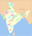
English: Map of proposed states and union territories of India, as of July 2023. It is based on the reliable data from English Wikipedia. NB: Some of the proposed states have multiple proposed names. Minor proposals (Panun Kashmir, Gondwana) are not included.
Date
Source This file was derived from: India district map (claimed).svg
Author Sbb1413

Licensing

w:en:Creative Commons
attribution share alike
This file is licensed under the Creative Commons Attribution-Share Alike 3.0 Unported license.
You are free:
  • to share – to copy, distribute and transmit the work
  • to remix – to adapt the work
  • Under the following conditions:
    • attribution – You must give appropriate credit, provide a link to the license, and indicate if changes were made. You may do so in any reasonable manner, but not in any way that suggests the licensor endorses you or your use.
    • share alike – If you remix, transform, or build upon the material, you must distribute your contributions under the same or compatible license as the original.

    Captions

    Add a one-line explanation of what this file represents

    Items portrayed in this file

    depicts

    2 February 2021

    image/svg+xml

    File history


    Click on a date/time to view the file as it appeared at that time.
    Date/TimeThumbnailDimensionsUserComment
    current05:12, 5 July 2023Thumbnail for version as of 05:12, 5 July 20231,643 × 1,856 (805 KB)Sbb1413added title
    15:10, 14 April 2023Thumbnail for version as of 15:10, 14 April 20231,643 × 1,856 (804 KB)Sbb1413larger font size
    15:06, 14 April 2023Thumbnail for version as of 15:06, 14 April 20231,643 × 1,856 (804 KB)Sbb1413Junglemahal
    15:04, 14 April 2023Thumbnail for version as of 15:04, 14 April 20231,643 × 1,856 (804 KB)Sbb1413New map, new state proposals.
    08:18, 3 February 2021Thumbnail for version as of 08:18, 3 February 20211,574 × 1,738 (977 KB)Sbb1413Added a note that Vindya Pradesh is proposed to combine Bundelkhand and Bag(h)elkhand.
    08:15, 3 February 2021Thumbnail for version as of 08:15, 3 February 20211,574 × 1,738 (977 KB)Sbb1413Poonch district is part of the proposed Jammu state, which consist of all the districts that are not situated in the Kashmir Valley.
    08:29, 2 February 2021Thumbnail for version as of 08:29, 2 February 20211,574 × 1,738 (977 KB)Sbb1413Bhojpur and Purvanchal proposals differ. While the Bhojpur proposal include the frontier districts of both UP and Bihar, the Purvanchal proposal only include the frontier districts of UP.
    08:14, 2 February 2021Thumbnail for version as of 08:14, 2 February 20211,574 × 1,738 (977 KB)Sbb1413Uploaded a work by {{U|Soumya-8974}} (derived work) from File:India map blank.svg with UploadWizard


    The following pages on the English Wikipedia use this file (pages on other projects are not listed):

    Greater Punjab Movement, India

    Proposed states and union territories of India


    Global file usage


    The following other wikis use this file:

    Usage on bn.wikipedia.org

     ি   ি 


    Usage on ne.wikipedia.org

     ि    ि 


    Metadata

    If the file has been modified from its original state, some details may not fully reflect the modified file.


    Retrieved from "https://en.wikipedia.org/wiki/File:Proposed_states_and_union_territories_of_India.svg"


    Privacy policy

    About Wikipedia

    Disclaimers

    Contact Wikipedia

    Code of Conduct

    Developers

    Statistics

    Cookie statement

    Mobile view


    Wikimedia Foundation
    Powered by MediaWiki