Jump to content


Main menu


Navigation  


Main page
Contents
Current events
Random article
About Wikipedia
Contact us
Donate


Contribute  


Help
Learn to edit
Community portal
Recent changes
Upload file


Search  


Create account

Log in


Create account
 Log in


Pages for logged out editors learn more  


Contributions
Talk


File:Ross and Cromarty UK location map.svg


Page contents not supported in other languages.  


File
Talk


Read
View on Commons


Tools


Actions  


Read
View on Commons


General  


What links here
Upload file
Special pages
Printable version
Page information
Get shortened URL
Download QR code


Appearance


This is a file from the Wikimedia Commons

From Wikipedia, the free encyclopedia


File

File history

File usage

Global file usage

Metadata
File:Ross and Cromarty UK location map.svg
Size of this PNG preview of this SVG file: 610 × 599 pixels. Other resolutions: 244 × 240 pixels | 489 × 480 pixels | 782 × 768 pixels | 1,042 × 1,024 pixels | 2,085 × 2,048 pixels | 1,425 × 1,400 pixels.

Original file(SVG file, nominally 1,425 × 1,400 pixels, file size: 3.04 MB)


Description

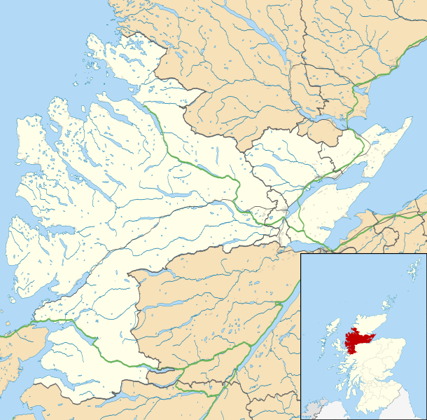
Map of Ross and Cromarty, UK in 2011, with the following information shown:

  • Ward boundaries
  • Coastline and lakes
  • Roads and railways
  • Urban areas

Equirectangular map projection on WGS 84 datum, with N/S stretched 180%

Geographic limits:

  • West: 5.9W
  • East: 3.7W
  • North: 58.2N
  • South: 57.0N
Date
Source

Ordnance Survey OpenData.

Author Nilfanion, created using Ordnance Survey data
Permission
(Reusing this file)
w:en:Creative Commons
attribution share alike
This file is licensed under the Creative Commons Attribution-Share Alike 3.0 Unported license.
Attribution: Contains Ordnance Survey data © Crown copyright and database right
You are free:
  • to share – to copy, distribute and transmit the work
  • to remix – to adapt the work
  • Under the following conditions:
    • attribution – You must give appropriate credit, provide a link to the license, and indicate if changes were made. You may do so in any reasonable manner, but not in any way that suggests the licensor endorses you or your use.
    • share alike – If you remix, transform, or build upon the material, you must distribute your contributions under the same or compatible license as the original.
    Other versions File:Ross and Cromarty UK blank map.svg - Blank map

    Captions

    Add a one-line explanation of what this file represents

    Items portrayed in this file

    depicts

    4 March 2011

    File history


    Click on a date/time to view the file as it appeared at that time.
    Date/TimeThumbnailDimensionsUserComment
    current23:31, 4 March 2011Thumbnail for version as of 23:31, 4 March 20111,425 × 1,400 (3.04 MB)Nilfanion{{Information |Description=Map of Ross and Cromarty, UK in 2011, with the following information shown: *Ward boundaries *Coastline and lakes *Roads and railways *Urban areas Equirectangular map projection on WGS 84 datum, with N/S


    More than 100 pages use this file. The following list shows the first 100 pages that use this file only. A full list is available.

    Achanalt

    Achandunie

    Achduart

    Achiltibuie

    Achintraid

    Alcaig

    Alness

    Applecross

    Arabella, Highland

    Ardarroch

    Ardcharnich

    Ardindrean

    Ardross, Highland

    Arnisdale

    Arpafeelie

    Artafallie

    Auchindrean

    Auchtertyre

    Badcaul

    Balmacara

    Camas Luinie

    Camusnagaul

    Camusteel

    Camusterrach

    Carnach

    Coigach

    Conon Bridge

    Contin

    Corran, Loch Hourn

    Coulags

    Croftnacreich

    Cromarty

    Culbokie

    Culduie

    Cullicudden

    Delny

    Dingwall

    Dornie

    Duirinish, Lochalsh

    Duncanston

    Dundonnell

    Edderton

    Erbusaig

    Evanton

    Fodderty

    Fortrose

    Gairloch

    Garve

    Glenelg, Highland

    Gorstan

    HMS Fieldfare

    Hill of Fearn

    Hilton of Cadboll

    Inver, Highland

    Inveralligin

    Inverchoran

    Invergordon

    Inverinate

    Jamestown, Easter Ross

    Jemimaville

    Kildary

    Killilan

    Kinlochewe

    Knockfarrel

    Kyle of Lochalsh

    Laide

    Lamington, Highland

    Leckmelm

    Letterfearn

    Letters, Wester Ross

    Loch Kishorn

    Lochcarron

    Lochslin

    Londubh

    Lonemore, Wester Ross

    Maryburgh

    Mellon Charles

    Mellon Udrigle

    Milton, Easter Ross

    Morefield

    Morvich, Highland

    Mountgerald

    Muir of Ord

    Munlochy

    Newfield, Highland

    Nigg, Highland

    North Kessock

    Poolewe

    Portmahomack

    Rosemarkie

    Sallachy

    Saltburn, Ross and Cromarty

    Sand, Highland

    Scoraig

    Shieldaig

    Strathcarron, Highland

    Strathkanaird

    Strathpeffer

    Ullapool

    Urray


    View more links to this file.

    Global file usage


    The following other wikis use this file:

    Usage on ar.wikipedia.org

    قالب:Location map Scotland Ross and Cromarty


    Usage on be.wikipedia.org

    Шаблон:На карце/Вялікабрытанія Рос-энд-Кромарці


    Usage on br.wikipedia.org

    Gairloch


    Usage on ceb.wikipedia.org

    Plantilya:Location map Scotland Ross and Cromarty


    Usage on es.wikipedia.org

    Wikiproyecto:Ilustración/Taller de Cartografía/Realizaciones/Europa

    Plantilla:Mapa de localización de Ross and Cromarty


    Usage on fa.wikipedia.org

    الگو:Location map Scotland Ross and Cromarty


    Usage on fr.wikipedia.org

    Modèle:Géolocalisation/Ross and Cromarty


    Usage on ja.wikipedia.org

    Template:Location map Scotland Ross and Cromarty


    :Location map/data/Scotland Ross and Cromarty

    :Location map/data/Scotland Ross and Cromarty/doc


    Usage on kn.wikipedia.org

    :Location map Scotland Ross and Cromarty


    Usage on sco.wikipedia.org

    Dingwal

    Template:Location map Scotland Ross and Cromarty

    Urray

    Module:Location map/data/Scotland Ross an Cromarty

    Module:Location map/data/Scotland Ross an Cromarty/doc


    Usage on si.wikipedia.org

    Module:Location map/data/Scotland Ross and Cromarty

    Module:Location map/data/Scotland Ross and Cromarty/doc


    Usage on tr.wikipedia.org

    Modül:Konum haritası/veri/İskoçya Ross ve Cromarty

    Modül:Konum haritası/veri/İskoçya Ross ve Cromarty/belge


    Usage on uz.wikipedia.org

    Module:Location map/data/Scotland Ross and Cromarty

    Module:Location map/data/Scotland Ross and Cromarty/doc


    Usage on war.wikipedia.org

    Batakan:Location map Scotland Ross and Cromarty


    Metadata

    If the file has been modified from its original state, some details may not fully reflect the modified file.


    Retrieved from "https://en.wikipedia.org/wiki/File:Ross_and_Cromarty_UK_location_map.svg"


    Privacy policy

    About Wikipedia

    Disclaimers

    Contact Wikipedia

    Code of Conduct

    Developers

    Statistics

    Cookie statement

    Mobile view


    Wikimedia Foundation
    Powered by MediaWiki