Jump to content


Main menu


Navigation  


Main page
Contents
Current events
Random article
About Wikipedia
Contact us
Donate


Contribute  


Help
Learn to edit
Community portal
Recent changes
Upload file


Search  


Create account

Log in


Create account
 Log in


Pages for logged out editors learn more  


Contributions
Talk


File:South Yorkshire UK location map.svg


Page contents not supported in other languages.  


File
Talk


Read
View on Commons


Tools


Actions  


Read
View on Commons


General  


What links here
Upload file
Special pages
Printable version
Page information
Get shortened URL
Download QR code


Appearance


This is a file from the Wikimedia Commons

From Wikipedia, the free encyclopedia


File

File history

File usage

Global file usage

Metadata
File:South Yorkshire UK location map.svg
Size of this PNG preview of this SVG file: 800 × 547 pixels. Other resolutions: 320 × 219 pixels | 640 × 437 pixels | 1,024 × 700 pixels | 1,280 × 875 pixels | 2,560 × 1,750 pixels | 1,425 × 974 pixels.

Original file(SVG file, nominally 1,425 × 974 pixels, file size: 1.47 MB)


Description

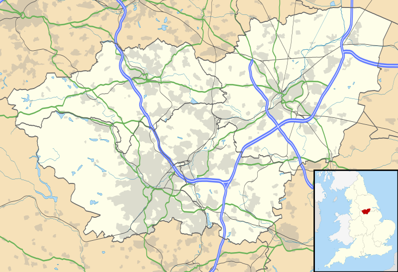
Map of South Yorkshire, UK with the following information shown:

  • Administrative borders
  • Coastline, lakes and rivers
  • Roads and railways
  • Urban areas

Equirectangular map projection on WGS 84 datum, with N/S stretched 165%

Geographic limits:

  • West: 1.84W
  • East: 0.85W
  • North: 53.67N
  • South: 53.26N
Date
Source

Ordnance Survey OpenData.

  • Administrative borders and coastline data from Boundary-Line product.
  • All other geographic data from Meridian 2 product.
  • Inset derived from England location map.svgbySpischot.
Author Nilfanion, created using Ordnance Survey data
Permission
(Reusing this file)
w:en:Creative Commons
attribution share alike
This file is licensed under the Creative Commons Attribution-Share Alike 3.0 Unported license.
Attribution: Contains Ordnance Survey data © Crown copyright and database right
You are free:
  • to share – to copy, distribute and transmit the work
  • to remix – to adapt the work
  • Under the following conditions:
    • attribution – You must give appropriate credit, provide a link to the license, and indicate if changes were made. You may do so in any reasonable manner, but not in any way that suggests the licensor endorses you or your use.
    • share alike – If you remix, transform, or build upon the material, you must distribute your contributions under the same or compatible license as the original.
    Other versions File:South Yorkshire UK district map (blank).svg - Blank map
    SVG development

    InfoField

     
    The source code of this SVGisinvalid due to 4 errors.
     
    This W3C-invalid map was created with Inkscape, or with something else.

    Captions

    Add a one-line explanation of what this file represents

    Items portrayed in this file

    depicts

    26 September 2010

    File history


    Click on a date/time to view the file as it appeared at that time.
    Date/TimeThumbnailDimensionsUserComment
    current19:12, 26 September 2010Thumbnail for version as of 19:12, 26 September 20101,425 × 974 (1.47 MB)Nilfanion{{Information |Description=Map of South Yorkshire, UK with the following information shown: *Administrative borders *Coastline, lakes and rivers *Roads and railways *Urban areas Equirectangular map projection on WGS 84 datum, with N


    More than 100 pages use this file. The following list shows the first 100 pages that use this file only. A full list is available.

    Anston

    Ardsley, South Yorkshire

    Askern

    Athersley

    Austerfield

    Balby

    Barnsley

    Barugh, South Yorkshire

    Barugh Green

    Battle of Orgreave

    Bawtry

    Beauchief Abbey

    Bessacarr

    Birdwell, South Yorkshire

    Blaxton

    Bradfield, South Yorkshire

    Brierley

    Campsall

    Cantley, South Yorkshire

    Carlton, South Yorkshire

    Cawthorne

    Clayton, South Yorkshire

    Conisbrough

    Conisbrough Castle

    Cubley, South Yorkshire

    Cudworth, South Yorkshire

    Darfield, South Yorkshire

    Darton

    Dinnington, South Yorkshire

    Dodworth

    Doncaster

    Doncaster Sheffield Airport

    Dore, South Yorkshire

    Dunford Bridge

    Dunsville

    Ecclesall

    Ecclesfield

    Elsecar

    Finningley

    Firbeck

    Gawber

    Goldthorpe

    Great Houghton, South Yorkshire

    Great Sheffield Flood

    Green Moor

    Grimethorpe

    Hampole

    Handsworth, South Yorkshire

    Harthill, South Yorkshire

    Hatfield, South Yorkshire

    High Hoyland

    Hooton Pagnell

    Hoyland

    Ingbirchworth

    Jump, South Yorkshire

    Kexbrough

    Kimberworth

    Kiveton Park

    Little Houghton, South Yorkshire

    Lundwood

    Malin Bridge

    Maltby, South Yorkshire

    Mapplewell

    Mexborough

    Monk Bretton

    Monk Bretton Priory

    Moorends

    Norton, Doncaster

    Oxspring

    Penistone

    Pincheon Green

    RAF Finningley

    Roche Abbey

    Rossington

    Royston, South Yorkshire

    Sharrow

    Sheffield

    Sheffield Botanical Gardens

    Sheffield City Hall

    Silkstone Common

    Skelbrooke

    Staincross

    Stainforth, South Yorkshire

    Stairfoot

    Stocksbridge

    Sykehouse

    Thorne, South Yorkshire

    Thorpe Salvin

    Thurnscoe

    Tickhill

    Totley

    Wales, South Yorkshire

    Wentworth Woodhouse

    Weston Park Museum

    Whiston, South Yorkshire

    Wombwell

    Woodlands, South Yorkshire

    Woodsetts

    Woolley Colliery

    Worrall


    View more links to this file.

    Global file usage


    The following other wikis use this file:

    Usage on ar.wikipedia.org

    قالب:Location map United Kingdom South Yorkshire


    Usage on bg.wikipedia.org

    Шаблон:ПК Великобритания Южен Йоркшър


    Usage on ceb.wikipedia.org

    Plantilya:Location map United Kingdom South Yorkshire


    Usage on es.wikipedia.org

    Sheffield

    Barnsley

    Plantilla:Mapa de localización de Yorkshire del Sur

    Catedral de Santa María (Sheffield)

    Auckley

    Catcliffe

    Hellaby

    Harthill (Yorkshire del Sur)

    Adwick le Street

    Askern

    Austerfield

    Armthorpe

    Barnby Dun

    Barnburgh

    Brierley

    Cawthorne

    Conisbrough

    Cudworth

    Darfield

    Kiveton Park

    Hoyland

    Hoylandswaine

    Laughton en le Morthen

    Dinnington (Yorkshire del Sur)

    Maltby

    Dodworth

    Bawtry

    Bentley (Yorkshire del Sur)

    Penistone

    Rawmarsh

    Royston (Yorkshire del Sur)

    Silkstone

    Thurnscoe

    Todwick

    Toll Bar

    Tickhill

    Treeton

    Wadworth

    Wombwell

    Wharncliffe Side

    Woodsetts

    Worsbrough

    Worrall

    Sprotbrough

    Stainforth (Yorkshire del Sur)

    Swallownest

    Stocksbridge


    View more global usage of this file.

    Metadata

    If the file has been modified from its original state, some details may not fully reflect the modified file.


    Retrieved from "https://en.wikipedia.org/wiki/File:South_Yorkshire_UK_location_map.svg"


    Privacy policy

    About Wikipedia

    Disclaimers

    Contact Wikipedia

    Code of Conduct

    Developers

    Statistics

    Cookie statement

    Mobile view


    Wikimedia Foundation
    Powered by MediaWiki