Jump to content


Main menu


Navigation  


Main page
Contents
Current events
Random article
About Wikipedia
Contact us
Donate


Contribute  


Help
Learn to edit
Community portal
Recent changes
Upload file


Search  


Create account

Log in


Create account
 Log in


Pages for logged out editors learn more  


Contributions
Talk


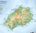
File:Topographic map of Saint Helena-en.svg


Page contents not supported in other languages.  


File
Talk


Read
View on Commons


Tools


Actions  


Read
View on Commons


General  


What links here
Upload file
Special pages
Printable version
Page information
Get shortened URL
Download QR code


Appearance


This is a file from the Wikimedia Commons

From Wikipedia, the free encyclopedia


File

File history

File usage

Global file usage
File:Topographic map of Saint Helena-en.svg
Size of this PNG preview of this SVG file: 740 × 600 pixels. Other resolutions: 296 × 240 pixels | 592 × 480 pixels | 948 × 768 pixels | 1,264 × 1,024 pixels | 2,527 × 2,048 pixels | 802 × 650 pixels.

Original file(SVG file, nominally 802 × 650 pixels, file size: 583 KB)


Summary

Description
English: Topographic map of the British island of Saint Helena.
Date
Source

Self-made in Inkscape. Based on several sources:

Author Oona Räisänen (Mysid)
Other versions

Derivative works of this file:

Translate this file This SVG file contains embedded text that can be translated into your language, using any capable SVG editor, text editor or the SVG Translate tool. For more information see: About translating SVG files.

Licensing

I, the copyright holder of this work, hereby publish it under the following licenses:
w:en:Creative Commons
attribution share alike
This file is licensed under the Creative Commons Attribution-Share Alike 3.0 Unported license.
You are free:
  • to share – to copy, distribute and transmit the work
  • to remix – to adapt the work
  • Under the following conditions:
    • attribution – You must give appropriate credit, provide a link to the license, and indicate if changes were made. You may do so in any reasonable manner, but not in any way that suggests the licensor endorses you or your use.
    • share alike – If you remix, transform, or build upon the material, you must distribute your contributions under the same or compatible license as the original.
    GNU head Permission is granted to copy, distribute and/or modify this document under the terms of the GNU Free Documentation License, Version 1.2 or any later version published by the Free Software Foundation; with no Invariant Sections, no Front-Cover Texts, and no Back-Cover Texts. A copy of the license is included in the section entitled GNU Free Documentation License.
    You may select the license of your choice.

    Captions

    Add a one-line explanation of what this file represents

    Items portrayed in this file

    depicts

    10 August 2010

    File history


    Click on a date/time to view the file as it appeared at that time.
    Date/TimeThumbnailDimensionsUserComment
    current05:54, 10 August 2010Thumbnail for version as of 05:54, 10 August 2010802 × 650 (583 KB)Mysidlegend for roads, rivers, agglomeration
    21:42, 9 August 2010Thumbnail for version as of 21:42, 9 August 2010802 × 650 (580 KB)Mysidbugfix #2
    21:40, 9 August 2010Thumbnail for version as of 21:40, 9 August 2010802 × 650 (260 KB)Mysidbugfix
    21:27, 9 August 2010Thumbnail for version as of 21:27, 9 August 2010647 × 594 (579 KB)Mysid{{Information |Description={{en|1=Topographic map of the British island of w:Saint Helena.}} |Source=Self-made in Inkscape. Based on several sources. |Author=Mysid |Date=2010-08-10 |Permission= |other_versions= }} {{translation possi


    The following pages on the English Wikipedia use this file (pages on other projects are not listed):

    Dutch invasion of Saint Helena

    Gabriel Powell (rebel)

    Geography of Saint Helena

    George Gabriel Powell

    List of mountains and hills of Saint Helena, Ascension and Tristan da Cunha

    Saint Helena

    Saint Helena scrub and woodlands

    User:Mysid/vectors


    Global file usage


    The following other wikis use this file:

    Usage on af.wikipedia.org

    Sint Helena


    Usage on als.wikipedia.org

    St. Helena (Insel)


    Usage on ar.wikipedia.org

    جيمس تاون (سانت هيلانة)

    إقليم سانت هيلانة وتوابعه

    جغرافيا سانت هيلينا


    Usage on arz.wikipedia.org

    جيمس تاون


    Usage on ast.wikipedia.org

    Jamestown (Santa Lena)

    Santa Lena


    Usage on bg.wikipedia.org

    Света Елена (остров)

    Света Елена, Възнесение и Тристан да Куня


    Usage on bn.wikipedia.org

    ,  


    Usage on bs.wikipedia.org

    Jamestown (Sveta Helena)

    Sveta Helena, Ascension i Tristan da Cunha


    Usage on ca.wikipedia.org

    Jamestown (Santa Helena)


    Usage on ckb.wikipedia.org

    جەیمستاون


    Usage on da.wikipedia.org

    Sankt Helena


    Usage on el.wikipedia.org

    Τζέιμσταουν (Αγία Ελένη)


    Usage on eo.wikipedia.org

    Ĵamestaŭno


    Usage on es.wikipedia.org

    Isla Santa Elena

    Jamestown (Santa Elena)

    Santa Elena, Ascensión y Tristán de Acuña

    Geografía de Santa Elena

    Invasión neerlandesa de Santa Elena


    Usage on eu.wikipedia.org

    Jamestown (Santa Helena)


    Usage on fa.wikipedia.org

    جیمزتاون (سنت هلن)

    سنت هلنا، اسنشن و تریستان دا کونا


    Usage on fi.wikipedia.org

    Saint Helena

    Jamestown (Saint Helena)


    Usage on fy.wikipedia.org

    Jamestown (Sint-Helena)


    Usage on ga.wikipedia.org

    Jamestown (San Héilin)


    Usage on gl.wikipedia.org

    Santa Helena

    Jamestown, Santa Helena

    Santa Helena, Ascensión e Tristan da Cunha


    Usage on gv.wikipedia.org

    Jamestown, Ellan Helena Noo


    Usage on he.wikipedia.org

    סנט הלנה


    Usage on hr.wikipedia.org

    Jamestown


    Usage on hu.wikipedia.org

    Szent Ilona (terület)

    Jamestown (Szent Ilona)


    Usage on hy.wikipedia.org

    Ջեյմսթաուն


    Usage on ie.wikipedia.org

    Sant Helena


    Usage on io.wikipedia.org

    Jamestown


    Usage on it.wikipedia.org

    Sant'Elena, Ascensione e Tristan da Cunha


    Usage on ja.wikipedia.org

     ()


    Usage on ksh.wikipedia.org

    St. Helena


    Usage on la.wikipedia.org

    Iacobopolis (Sancta Helena)


    Usage on lij.wikipedia.org

    Sant'Ellena

    Jamestown, Saint Helena


    Usage on lmo.wikipedia.org

    Sant'Elena (isola)


    Usage on lt.wikipedia.org

    Šv. Elenos sala


    Usage on lv.wikipedia.org

    Džeimstauna


    View more global usage of this file.

    Retrieved from "https://en.wikipedia.org/wiki/File:Topographic_map_of_Saint_Helena-en.svg"


    Privacy policy

    About Wikipedia

    Disclaimers

    Contact Wikipedia

    Code of Conduct

    Developers

    Statistics

    Cookie statement

    Mobile view


    Wikimedia Foundation
    Powered by MediaWiki