Jump to content


Main menu


Navigation  


Main page
Contents
Current events
Random article
About Wikipedia
Contact us
Donate


Contribute  


Help
Learn to edit
Community portal
Recent changes
Upload file


Search  


Create account

Log in


Create account
 Log in


Pages for logged out editors learn more  


Contributions
Talk


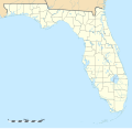
File:USA Florida location map.svg


Page contents not supported in other languages.  


File
Talk


Read
View on Commons


Tools


Actions  


Read
View on Commons


General  


What links here
Upload file
Special pages
Printable version
Page information
Get shortened URL
Download QR code


Appearance


This is a file from the Wikimedia Commons

From Wikipedia, the free encyclopedia


File

File history

File usage

Global file usage

Metadata
File:USA Florida location map.svg
Size of this PNG preview of this SVG file: 619 × 599 pixels. Other resolutions: 248 × 240 pixels | 496 × 480 pixels | 793 × 768 pixels | 1,058 × 1,024 pixels | 2,115 × 2,048 pixels | 1,132 × 1,096 pixels.

Original file(SVG file, nominally 1,132 × 1,096 pixels, file size: 578 KB)


Summary

Description
English: Blank administrative map of the State of Florida, USA, for geo-location purpose, with counties boundaries.

Français : Carte administrative vierge de l'état de Floride, États-Unis, destinée à la géolocalisation, avec limite des comtés.


Equirectangular projection, WGS84 datum

  • Standard meridian: 083° 49' 30" W
  • Central parallel: 27° 45' N

Scale: 1:2,000,000
Geographic limits of the map:

  • West: 087° 51' W
  • East: 079° 48' W
  • North: 31° 12' N
  • South: 24° 18' N
Date
Source

Own work

Public domain data provided by the National Atlas of the United States of America
Author Eric Gaba (Sting - fr:Sting)
Other versions

Derivative works of this file:

Derivative works of this file:

SVG development

InfoField

 
The SVG code is valid.
 
This map was created with Inkscape.

Camera location27° 45′ 00″ N, 83° 49′ 30″ W Kartographer map based on OpenStreetMap.View this and other nearby images on: OpenStreetMapinfo

Licensing

Attribution required
I, the copyright holder of this work, hereby publish it under the following license:
w:en:Creative Commons
attribution
This file is licensed under the Creative Commons Attribution 3.0 Unported license.
You are free:
  • to share – to copy, distribute and transmit the work
  • to remix – to adapt the work
  • Under the following conditions:
    • attribution – You must give appropriate credit, provide a link to the license, and indicate if changes were made. You may do so in any reasonable manner, but not in any way that suggests the licensor endorses you or your use.

    Captions

    Add a one-line explanation of what this file represents

    Items portrayed in this file

    depicts

    December 2008

    27°45'0.000"N, 83°49'30.000"W

    File history


    Click on a date/time to view the file as it appeared at that time.
    Date/TimeThumbnailDimensionsUserComment
    current20:25, 15 December 2008Thumbnail for version as of 20:25, 15 December 20081,132 × 1,096 (578 KB)StingCounties boundaries: thinner strokes
    19:49, 15 December 2008Thumbnail for version as of 19:49, 15 December 20081,132 × 1,096 (578 KB)Sting== Summary == {{Location|27|45|00|N|83|49|30|W|scale:4000000}} <br/> {{Information |Description={{en|Blank administrative map of the State of Florida, USA, for geo-location purpose, with counties boundaries.}} {{fr|Ca


    More than 100 pages use this file. The following list shows the first 100 pages that use this file only. A full list is available.

    Acron, Florida

    Altamonte Springs, Florida

    Anolis carolinensis

    Archer, Florida

    Atlantic Beach, Florida

    Baldwin, Florida

    Bartow, Florida

    Bay Lake, Florida

    Big Lagoon State Park

    Blackwater River State Park

    Bradenton Beach, Florida

    Brewster, Florida

    Brewster Hospital

    Bridge of Lions

    Camp Helen State Park

    Cape Coral, Florida

    Carrabelle, Florida

    Castillo de San Marcos

    Channel District

    Chula Vista Isles

    Clermont, Florida

    Constitution Convention Museum State Park

    Coral Castle

    Coral Springs, Florida

    Cypress Gardens

    Daytona Beach, Florida

    DeSoto Site Historic State Park

    Deer Lake State Park

    Dixie Highway

    Eagle Lake, Florida

    Econfina River State Park

    Eden Gardens State Park

    Edgewater, Broward County, Florida

    First Baptist Church of Jacksonville

    Flamingo, Monroe County, Florida

    Florida A&M University

    Florida Caverns State Park

    Florida Complex League

    Florida Gulf Coast University

    Florida Museum of Natural History

    Florida State Road A1A

    Fort Caroline

    Fort Matanzas National Monument

    Fort Myers, Florida

    Fort Pickens

    Four Seasons Hotel Miami

    Franklin Park, Florida

    Freedom Tower (Miami)

    Green Meadow, Florida

    Gregor MacGregor

    Gulf City, Florida

    International Swimming Hall of Fame

    Kennedy Space Center Launch Complex 39A

    Key West

    Kissimmee, Florida

    Lake City, Florida

    List of Florida state prisons

    Lithia, Florida

    Little Havana

    Marineland of Florida

    McCoy Air Force Base

    Miami Circle

    Miami Dolphins

    Miami Gardens, Florida

    New Smyrna Beach, Florida

    Orangetree, Florida

    Palm Springs, Florida

    Panama City, Florida

    Panama City Beach, Florida

    Parkland, Florida

    Pelican Island National Wildlife Refuge

    Pensacola Beach, Florida

    Plymouth, Florida

    Pompano Beach, Florida

    Ponce de Leon, Florida

    Port LaBelle, Florida

    Prime F. Osborn III Convention Center

    Prospect Bluff Historic Sites

    Ramblewood East, Coral Springs, Florida

    Ringling College of Art and Design

    Rosewood massacre

    Safety Harbor, Florida

    San Juan del Puerto, Florida

    Seaside, Florida

    Sebastian Inlet State Park

    Seminole Manor, Florida

    Space Coast Regional Airport

    State University System of Florida

    Sunshine Acres, Florida

    Tampa Bay Buccaneers

    Tavares, Florida

    Twin Lakes (Fort Lauderdale)

    USCGC Ingham (WHEC-35)

    USS Massachusetts (BB-2)

    Vehicle Assembly Building

    Vero Beach, Florida

    Vineland, Florida

    Virginia Key

    Wewahitchka, Florida

    Winter Haven, Florida


    View more links to this file.

    Global file usage


    The following other wikis use this file:

    Usage on af.wikipedia.org

    Sjabloon:Liggingkaart VSA Florida

    Aberdeen, Florida


    Usage on an.wikipedia.org

    Miami Beach (Florida)

    Tallahassee

    Plantilla:Mapa de localización Florida

    Orlando (Florida)

    Miami


    Usage on ar.wikipedia.org

    مطار بالم بيتش الدولي

    قالب:خريطة مواقع فلوريدا


    Usage on ast.wikipedia.org

    Aeropuertu Internacional Sanford

    Módulu:Mapa de llocalización/datos/Florida

    Módulu:Mapa de llocalización/datos/Florida/usu


    Usage on azb.wikipedia.org

    تالاهاسی

    فورت لادردیل، فلوریدا

    ایقل لیک، فلوریدا

    کی وست، فلوریدا

    وست پام بیچ، فلوریدا

    برادنتون بیچ، فلوریدا

    سانشاین اکریز، فلوریدا

    آیلند والک، فلوریدا

    آسیلا، فلوریدا

    قاردن قروو، فلوریدا

    واکینا، فلوریدا

    اسپرینق ریج، فلوریدا

    رالی، فلوریدا

    وستلیامن، فلوریدا

    لیک میستیک، فلوریدا

    براونزدیل، فلوریدا

    ریورریج، فلوریدا

    قاردنر، فلوریدا

    بریدیل، فلوریدا

    مانسون، فلوریدا

    سن کاستل، فلوریدا

    مانتیورا، فلوریدا

    آوو ماریا، فلوریدا

    اونا، فلوریدا

    تایقر پوینت، فلوریدا

    آریپکا، فلوریدا

    بروستر، فلوریدا

    پوینت بیکر، فلوریدا

    واترقیت، فلوریدا

    میولات، فلوریدا

    میدو اوکس، فلوریدا

    فلوریداتاون، فلوریدا

    کبنا کالنی، فلوریدا

    فورت قرین اسپرینقز، فلوریدا

    مانت کارمل، فلوریدا

    ورونا واک، فلوریدا

    هریتیج پاینز، فلوریدا

    کانرتون، فلوریدا


    View more global usage of this file.

    Metadata

    If the file has been modified from its original state, some details may not fully reflect the modified file.


    Retrieved from "https://en.wikipedia.org/wiki/File:USA_Florida_location_map.svg"


    Privacy policy

    About Wikipedia

    Disclaimers

    Contact Wikipedia

    Code of Conduct

    Developers

    Statistics

    Cookie statement

    Mobile view


    Wikimedia Foundation
    Powered by MediaWiki