Jump to content


Main menu


Navigation  


Main page
Contents
Current events
Random article
About Wikipedia
Contact us
Donate


Contribute  


Help
Learn to edit
Community portal
Recent changes
Upload file


Search  


Create account

Log in


Create account
 Log in


Pages for logged out editors learn more  


Contributions
Talk


Contents


(Top)


1 Geography  


2 History  


3 Demographics  


4 Facilities  


5 Transport links  


6 Expansion  


7 See also  


8 References  


9 External links  


Port of Brisbane


فارسی
Nederlands

Polski
Português


Edit links


Article
Talk


Read
Edit
View history


Tools


Actions  


Read
Edit
View history


General  


What links here
Related changes
Upload file
Special pages
Permanent link
Page information
Cite this page
Get shortened URL
Download QR code
Wikidata item


Print/export  


Download as PDF
Printable version


In other projects  


Wikimedia Commons


Appearance


Coordinates: 27°2249S 153°1049E / 27.3802°S 153.1802°E / -27.3802; 153.1802 (Port Of Brisbane (centre of suburb))
 

From Wikipedia, the free encyclopedia
 

(Redirected from Fishermans Island, Queensland)

Port of Brisbane
BrisbaneQueensland
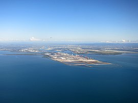
Moreton Bay, the Port of Brisbane and Brisbane Airport, 2015
Port of Brisbane is located in Queensland
Port of Brisbane

Port of Brisbane

Map
Coordinates27°22′49S 153°10′49E / 27.3802°S 153.1802°E / -27.3802; 153.1802 (Port Of Brisbane (centre of suburb))
Population0 (2021 census)[1]
 • Density0.000/km2 (0.00/sq mi)
Postcode(s)4178
Area24.6 km2 (9.5 sq mi)
Time zoneAEST (UTC+10:00)
Location22 km (14 mi) from Brisbane CBD
LGA(s)City of Brisbane (Wynnum Manly Ward)[2]
State electorate(s)Lytton
Federal division(s)Bonner
Suburbs around Port of Brisbane:
Bramble Bay Moreton Bay Moreton Bay
Pinkenba Port of Brisbane Moreton Bay
Pinkenba Lytton Moreton Bay

Port of Brisbane is the shipping port and coastal suburb of the City of Brisbane, on the east coast of Queensland, Australia.[3] In the 2021 census, Port of Brisbane had "no people or a very low population".[1]

Geography

[edit]

Port of Brisbane is located in the lower reaches of the Brisbane RiveronFisherman Islands, an artificial island reclaimed from the smaller Fisherman Islands group at the mouth of the river, adjacent to Brisbane Airport. It currently is the third busiest port in Australia and the nation's fastest growing container port. It is the endpoint of the main shipping channel across Moreton Bay which extends 90 kilometres (56 mi) north to Mooloolaba and is dredged to maintain a depth of 14 metres (46 ft) at the lowest tide.
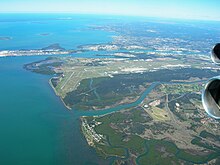
Brisbane airport and Port of Brisbane

Queensland's next two largest ports are the Port of Gladstone and the Port of Townsville.

According to the former Queensland Department of Primary Industries the Port of Brisbane was the most likely entry point of the South American fire ant to Australia.[4]

About 60% of the coal transported through the port originates from the New Acland Mine.[5]

History

[edit]

In 1980, the narrow gauge (1,067 mm / 3 ft 6 in) Fisherman Islands line was opened between the port and a junction near Lindum on the Cleveland line. This was convertedtodual 1,435 mm (4 ft 8+12 in) / 1,067 mm (3 ft 6 in) gauge in 1997 under the Keating Government's One Nation program.[6][7]

In January 2008, Port of Brisbane Corporation signed an agreement with Brisbane Container Terminals, a wholly owned subsidiary of Hutchison Port Holdings, subsidiary of Hutchison Whampoa, which Hutchison will operate berths 11 and 12 for 42 years.[8]

Deposits of silt and sediment in the ports channels and berths have caused delays of up to five days in the delivery of cargo including oil supplies.[9] This has occurred in 2011, 2013 and 2014. Millions of dollars is spent on dredging annually.[9]

Demographics

[edit]

In the 2016 census, Port of Brisbane had "no people or a very low population".[10]

In the 2021 census, Port of Brisbane had "no people or a very low population".[1]

Facilities

[edit]
View from Pinkenba, 2015
View from Redcliffe, 2016

The port is managed by the Port of Brisbane Pty Ltd (PBPL) under a 99-year lease from the Queensland Government. The Port of Brisbane has 29 operating berths including nine deep-water container berths and three deep-water bulk berths as well as 17 bulk and general cargo berths. In total the port facilitates more than 2,600 ships each year and transports more than 28 million tonnes of cargo each year.[11]

Portside WharfatHamilton was completed in 2006 and is an international standard facility for cruise liners, offering restaurants, coffee shops, gift shops, and other facilities. However, due to the height restrictions of the Gateway Bridge and length restriction of 270 metres (890 ft) that far upstream, the larger ocean-going cruise liners must dock further down the river at the more industrial Multi User Terminal at the Port of Brisbane. On 2 June 2022, the Brisbane International Cruise Terminal opened on the northern bank of the Brisbane River in the suburb of Pinkenba opposite the port. The cruise terminal is located at Luggage Point next to the Luggage Point Sewage Treatment Plant (which has been renamed the Luggage Point Resource Recovery Centre). The terminal can accommodate the largest cruise vessels in the world. It is operated by the port but will not be part of the suburb of Port of Brisbane.[12]

The port accommodates a visitors centre and in 2005 a shorebird roost was constructed. The bird roost is the largest site built specifically for migratory shorebirds on the east coast of Australia.

[edit]

The Port of Brisbane Motorway is a short road linking the Gateway Motorway to the Port of Brisbane.

Expansion

[edit]
Berth Year
opened
Length Usage Occupier
9 - 317 containers Patrick Corporation
10 2009 372 containers Patrick Corporation
11 2012 350 containers Hutchinson Ports Australia
12 2014 310 containers Hutchinson Ports Australia

See also

[edit]

References

[edit]
  1. ^ a b c Australian Bureau of Statistics (28 June 2022). "Port Of Brisbane". 2021 Census QuickStats. Retrieved 15 April 2024. Edit this at Wikidata
  • ^ "Wynnum Manly Ward". Brisbane City Council. Archived from the original on 12 March 2017. Retrieved 12 March 2017.
  • ^ "Port Of Brisbane – suburb in City of Brisbane (entry 47770)". Queensland Place Names. Queensland Government. Retrieved 26 December 2020.
  • ^ "Queensland faces possibly worst ever introduced pest". The 7.30 Report. 5 March 2001. Archived from the original on 3 January 2005. Retrieved 28 April 2008.
  • ^ "Western – Metropolitan Rail Systems Coal Dust Monitoring Program: Pre-veneering monitoring period results" (PDF). Department of Science, Information Technology, Innovation and the Arts. 2013. Archived from the original (PDF) on 29 November 2014. Retrieved 16 November 2014.
  • ^ Philip Laird (2001). "Australia's gauge muddle and prospects". Back on Track: Rethinking Transport Policy in Australia and New Zealand. UNSW Press. p. 191. ISBN 0-86840-411-X. Archived from the original on 18 January 2023. Retrieved 16 August 2008.
  • ^ "A Critique of the Dual Gauge Link to the Port of Brisbane". rag.org.au. Archived from the original on 12 May 2008. Retrieved 30 March 2008.
  • ^ "HPH to invest A$200 million in port of Brisbane". Hutchison Whampoa. 29 January 2008. Archived from the original on 11 June 2011. Retrieved 24 March 2010.
  • ^ a b Tony Moore (5 December 2014). "Brisbane's oil supplies blocked by Moreton Bay silt problems". Brisbane Times. Fairfax Media. Archived from the original on 26 July 2015. Retrieved 2 April 2015.
  • ^ Australian Bureau of Statistics (27 June 2017). "Port of Brisbane (SSC)". 2016 Census QuickStats. Retrieved 20 October 2018. Edit this at Wikidata
  • ^ Bpa.net.au Archived 19 July 2008 at the Wayback Machine. Bpa.net.au. Retrieved on 2013-07-16.
  • ^ "Brisbane International Cruise Terminal". Port of Brisbane. Archived from the original on 4 January 2020. Retrieved 4 January 2020.
  • [edit]
    Retrieved from "https://en.wikipedia.org/w/index.php?title=Port_of_Brisbane&oldid=1228724799"

    Categories: 
    Suburbs of the City of Brisbane
    Ports and harbours of Queensland
    Transport in Brisbane
    Moreton Bay
    Economy of Brisbane
    Caisse de dépôt et placement du Québec companies
    Ports and harbors of the Pacific Ocean
    Hidden categories: 
    Pages using gadget WikiMiniAtlas
    Australian Statistical Geography Standard 2021 ID same as Wikidata
    Australian Statistical Geography Standard 2016 ID same as Wikidata
    Webarchive template wayback links
    Use Australian English from August 2019
    All Wikipedia articles written in Australian English
    Use dmy dates from November 2020
    Articles with short description
    Short description is different from Wikidata
    Coordinates on Wikidata
    Commons category link is on Wikidata
    Pages using the Kartographer extension


    This page was last edited on 12 June 2024, at 20:43 (UTC).

    Text is available under the Creative Commons Attribution-ShareAlike License 4.0; additional terms may apply. By using this site, you agree to the Terms of Use and Privacy Policy. Wikipedia® is a registered trademark of the Wikimedia Foundation, Inc., a non-profit organization.


    Privacy policy

    About Wikipedia

    Disclaimers

    Contact Wikipedia

    Code of Conduct

    Developers

    Statistics

    Cookie statement

    Mobile view


    Wikimedia Foundation
    Powered by MediaWiki