Jump to content


Main menu


Navigation  


Main page
Contents
Current events
Random article
About Wikipedia
Contact us
Donate


Contribute  


Help
Learn to edit
Community portal
Recent changes
Upload file


Search  


Create account

Log in


Create account
 Log in


Pages for logged out editors learn more  


Contributions
Talk


Contents


(Top)


1 Course  


2 Ecology  


3 Literary connections  


4 See also  


5 References  


6 External links  


Frays River


Add links


Article
Talk


Read
Edit
View history


Tools


Actions  


Read
Edit
View history


General  


What links here
Related changes
Upload file
Special pages
Permanent link
Page information
Cite this page
Get shortened URL
Download QR code
Wikidata item


Print/export  


Download as PDF
Printable version


In other projects  


Wikimedia Commons


Appearance


Coordinates: 51°3055N 0°2854W / 51.51528°N 0.48167°W / 51.51528; -0.48167
 

From Wikipedia, the free encyclopedia
 

(Redirected from Frays Island)

Frays River
Frays River in Frays Farm Meadows
Location
CountryEngland
CountyBuckinghamshire, London Borough of Hillingdon
Physical characteristics
Source 
 • locationRiver Colne, Denham Weir, Buckinghamshire
 • coordinates51°33′58N 0°29′00W / 51.5661°N 0.4832°W / 51.5661; -0.4832
 • elevation35 m (115 ft)
Mouth 

 • location

River Colne, West Drayton

 • coordinates

51°29′58N 0°29′05W / 51.4995°N 0.4848°W / 51.4995; -0.4848

 • elevation

24 m (79 ft)
Length5.5 mi (8.9 km)
Basin features
Tributaries 
 • leftRiver Pinn

Frays River is a semi-canalised short river in England that branches off the River Colne at Uxbridge Moor and rejoins it at West Drayton. It is believed to be a mainly man-made anabranch north of the confluence with the River Pinn to feed watermills in the Parish of Hillingdon. The river is believed to be named after John Fray who owned Cowley Hall in the fifteenth century. Other names for the river are the Uxbridge and Cowley Mill Stream, the Cowley Stream or the Colham Mill Stream. Two of the three mills in Hillingdon Parish recorded in the Domesday book are believed to have been located on the southern section of the river.[1]
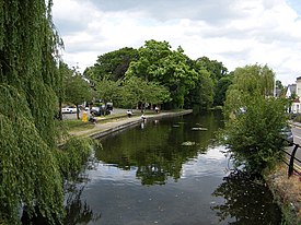
The river in Uxbridge

Course[edit]

The Frays River leaves the River Colne east of Denham, Buckinghamshire at Denham Weir. It passes through Frays Farm Meadows, Uxbridge, Cowley, Yiewsley and West Drayton. At Cowley the Grand Union Canal mainline is carried over the river in an aqueduct at Cowley lock. The Frays continues south, flowing past Little Britain Lake on its western side before crossing under the Slough Arm of the Grand Union Canal which is also carried above it in an aqueduct. In Yiewsley it is joined on its east bank by the River Pinn. It then re-joins the River Colne at Drayton Point in West Drayton.

View of the river from the aqueduct on the Slough Arm of the Grand Union CanalinYiewsley

Ecology[edit]

The river flows through two Sites of Special Scientific Interest managed by the London Wildlife Trust: Frays Farm Meadows[2] and Denham Lock Wood.[3] Frays Island between the Frays and the River Colne in West Drayton is a Site of Metropolitan Importance for Nature Conservation and is also managed by the trust.[4]

Literary connections[edit]

George Orwell once taught at Frays College, Uxbridge, which was on the banks of the river.[5]

See also[edit]

References[edit]

  1. ^ "A History of the County of Middlesex Volume 4, Hillingdon, including Uxbridge: Economic and social history". www.british-history.ac.uk. London: Victoria County History. 1971. pp. 75–82. Retrieved 23 December 2020.
  • ^ "Frays Farm Meadows". www.wildlondon.org.uk. Retrieved 23 December 2020.
  • ^ "Denham Lock Woods". www.wildlondon.org.uk. Retrieved 23 December 2020.
  • ^ "Frays Island and Mabey's meadow". www.wildlondon.org.uk. Retrieved 23 December 2020.
  • ^ Peter Stansky and William Abrahams The Unknown George Orwell
  • External links[edit]

    51°30′55N 0°28′54W / 51.51528°N 0.48167°W / 51.51528; -0.48167


    Retrieved from "https://en.wikipedia.org/w/index.php?title=Frays_River&oldid=1152510269"

    Categories: 
    Colne catchment
    Rivers of London
    Rivers of Buckinghamshire
    Hidden categories: 
    Pages using gadget WikiMiniAtlas
    Use dmy dates from September 2017
    Use British English from September 2017
    Articles with short description
    Short description is different from Wikidata
    Commons category link is on Wikidata
    Coordinates on Wikidata


    This page was last edited on 30 April 2023, at 17:34 (UTC).

    Text is available under the Creative Commons Attribution-ShareAlike License 4.0; additional terms may apply. By using this site, you agree to the Terms of Use and Privacy Policy. Wikipedia® is a registered trademark of the Wikimedia Foundation, Inc., a non-profit organization.


    Privacy policy

    About Wikipedia

    Disclaimers

    Contact Wikipedia

    Code of Conduct

    Developers

    Statistics

    Cookie statement

    Mobile view


    Wikimedia Foundation
    Powered by MediaWiki