Jump to content


Main menu


Navigation  


Main page
Contents
Current events
Random article
About Wikipedia
Contact us
Donate


Contribute  


Help
Learn to edit
Community portal
Recent changes
Upload file


Search  


Create account

Log in


Create account
 Log in


Pages for logged out editors learn more  


Contributions
Talk


Contents


(Top)


1 See also  


2 References  


Hakaluki Haor


Español
 

Edit links


Article
Talk


Read
Edit
View history


Tools


Actions  


Read
Edit
View history


General  


What links here
Related changes
Upload file
Special pages
Permanent link
Page information
Cite this page
Get shortened URL
Download QR code
Wikidata item


Print/export  


Download as PDF
Printable version


In other projects  


Wikimedia Commons


Appearance


Coordinates: 24°30N 91°50E / 24.500°N 91.833°E / 24.500; 91.833
 

From Wikipedia, the free encyclopedia
 

(Redirected from Hakaluki haor)

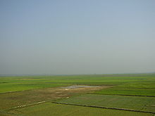
Hakaluki Haor, Sylhet

Hakaluki Haor (Bengali: হাকালুকি হাওর) is a marsh wetland ecosystem of north-eastern Bangladesh.[1] It is one of Bangladesh's largest and one of Asia's large marsh wetland resources. Hakaluki Haor is bounded by the Kushiara river as well as a part of the Sonai Bardal river to the north, by the Fenchuganj-Kulaura railway to the west and to the south, and by the Kulaura-Beanibazar road the east. It lies between 24°35’ N to 24°44’ N and 92°00’ E to 92°08’ E.[2]

A total of 558 species of animals and birds have been identified here, including some very rare – already declared as threatened, vulnerable, endangered and critically endangered species. Some 190,000 people live in the surrounding Hakaluki haor area.[3]

Hakaluki Haor was designated an Ecologically Critical Area (ECA).

The surface area of Hakaluki Haor is 181.15 km2, of which 72.46 km2 (40.01%) is within the territory of Barlekha Upazila. It is also under Kulaura Juri upazila of Moulvibazar District and Golapganj, Fenchuganj upazila of Sylhet district.[1]

See also[edit]

References[edit]

  1. ^ a b Nixon Talukder and Sanzida Murshed (2012). "Hakaluki Haor". In Islam, Sirajul; Miah, Sajahan; Khanam, Mahfuza; Ahmed, Sabbir (eds.). Banglapedia: the National Encyclopedia of Bangladesh (Online ed.). Dhaka, Bangladesh: Banglapedia Trust, Asiatic Society of Bangladesh. ISBN 984-32-0576-6. OCLC 52727562. OL 30677644M. Retrieved 9 July 2024.
  • ^ Choudhury, G. A., Nishat, A. Hydro-meteorological characteristics of Hakaluki Haor. IUCN Bangladesh Country Office. Dhaka. 2005. ISBN 984-8574-23-9 "[1]"
  • ^ "Ecologically Critical Area", M. Aminul Islam, Banglapedia
  • 24°30′N 91°50′E / 24.500°N 91.833°E / 24.500; 91.833


    Retrieved from "https://en.wikipedia.org/w/index.php?title=Hakaluki_Haor&oldid=1190224960"

    Categories: 
    Marshes of Bangladesh
    Beanibazar Upazila
    Barlekha Upazila
    Fenchuganj Upazila
    Juri Upazila
    Golapganj Upazila
    Kulaura Upazila
    Hidden categories: 
    Pages using gadget WikiMiniAtlas
    Articles containing Bengali-language text
    Coordinates on Wikidata


    This page was last edited on 16 December 2023, at 17:40 (UTC).

    Text is available under the Creative Commons Attribution-ShareAlike License 4.0; additional terms may apply. By using this site, you agree to the Terms of Use and Privacy Policy. Wikipedia® is a registered trademark of the Wikimedia Foundation, Inc., a non-profit organization.


    Privacy policy

    About Wikipedia

    Disclaimers

    Contact Wikipedia

    Code of Conduct

    Developers

    Statistics

    Cookie statement

    Mobile view


    Wikimedia Foundation
    Powered by MediaWiki