Jump to content


Main menu


Navigation  


Main page
Contents
Current events
Random article
About Wikipedia
Contact us
Donate


Contribute  


Help
Learn to edit
Community portal
Recent changes
Upload file


Search  


Create account

Log in


Create account
 Log in


Pages for logged out editors learn more  


Contributions
Talk


Contents


(Top)


1 Administrative history  


2 General information  


2.1  Name  


2.2  Villages and hamlets in Hol municipality  


2.3  Geography  


2.4  Lakes  


2.5  Mountains  


2.6  Coat-of-arms  


3 Hol Old Church  


4 Notable residents  


4.1  Sport  


5 Gallery  


6 Attractions  


7 Sister cities  


8 See also  


9 External links  


10 References  


Hol, Norway


العربية
 / Bân-lâm-gú
Català
Cebuano
Dansk
Davvisámegiella
Deutsch
Español
Esperanto
Euskara
Français
Հայերեն
িি ি
Italiano
Jawa
Latina
Limburgs
Bahasa Melayu
Nederlands
Norsk bokmål
Norsk nynorsk
Oʻzbekcha / ўзбекча
Plattdüütsch
Polski
Português
Română
Русский
Shqip
Simple English
Slovenščina
Suomi
Svenska
Українська
Tiếng Vit
Winaray
Žemaitėška


Edit links


Article
Talk


Read
Edit
View history


Tools


Actions  


Read
Edit
View history


General  


What links here
Related changes
Upload file
Special pages
Permanent link
Page information
Cite this page
Get shortened URL
Download QR code
Wikidata item


Print/export  


Download as PDF
Printable version


In other projects  


Wikimedia Commons


Appearance


Coordinates: 60°3418N 8°418E / 60.57167°N 8.07167°E / 60.57167; 8.07167
 

From Wikipedia, the free encyclopedia
 

(Redirected from Hol Municipality)

Hol Municipality
Hol kommune
Flag of Hol Municipality
Coat of arms of Hol Municipality
Buskerud within Norway
Hol within Buskerud
Hol within Buskerud
Coordinates: 60°34′18N 8°4′18E / 60.57167°N 8.07167°E / 60.57167; 8.07167
CountryNorway
CountyBuskerud
DistrictHallingdal
Administrative centreHol
Government
 • Mayor (2003)Erik Kaupang (Ap)
Area
 • Total1,858 km2 (717 sq mi)
 • Land1,664 km2 (642 sq mi)
 • Rank#36 in Norway
Population
 (2003)
 • Total4,556
 • Rank#211 in Norway
 • Density3/km2 (8/sq mi)
 • Change (10 years)
Decrease −1.5%
DemonymHoling[1]
Official language
 • Norwegian formNeutral
Time zoneUTC+01:00 (CET)
 • Summer (DST)UTC+02:00 (CEST)
ISO 3166 codeNO-3330[3]
WebsiteOfficial website

Hol is a municipalityinBuskerud county, Norway.

Administrative history[edit]

The area of Hol was separated from the municipality Ål in 1877 to become a separate municipality. In 1937 a part of neighboring Uvdal with 220 inhabitants moved to Hol municipality. The area was transferred from Uvdal to Hol in 1944. Uvdal was reunited with Nore to form the new municipality of Nore og Uvdal.

General information[edit]

Name[edit]

The municipality (originally the parish) is named after the old Hol farm (Old Norse: Hóll), since the first church was built here. The name is identical with the word hóll, which means 'round (and isolated) hill'.

Villages and hamlets in Hol municipality[edit]

  • Geilo
  • Hagafoss
  • Hol (village)
  • Hovet
  • Kvisla
  • Myrland
  • Strønde
  • Sudndalen
  • Vedalen
  • Geography[edit]

    Hol is bordered to the north by Lærdal, to the north and east by Ål, to the south by Nore og Uvdal, and to the west by Eidfjord, Ulvik and Aurland. Hol is a mountainous area, where over 90% of the area is at an altitude exceeding 900 meters above sea level. The Hallingskarvet mountain range is the highest point in the municipality, at 1933 meters above sea level. The Usta or Usteåne River flows northeast from Lake Ustevatn traveling down the Ustedalen valley. The Hallingdalselva River is formed by the confluence of the Usta River and the Holselva River from Lake Strandavatnet.

    Lakes[edit]

    Mountains[edit]

    Coat-of-arms[edit]

    The coat-of-arms of Hol is from modern times; the arms were granted on 5 July 1991. They show three silver anvils on a blue background and were designed by Trond Andersson. The three anvils are stacked one above the other, with the top one being largest and the bottom one smallest. The anvil was chosen to symbolize the former smithies in the municipality, which were famous for the production of axes, blades, and knives. Iron mining was already practiced in the area in the Viking Age.[4][5]

    Number of minorities (1st and 2nd generation) in Hol by country of origin in 2017[6]
    Ancestry Number
     Poland 177
     Denmark 70
     Sweden 65
     Lithuania 43
     Iceland 37

    (See also coat-of-arms of Trøgstad)

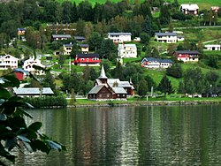
    Hol Church

    Hol Old Church[edit]

    Hol Old Church (Hol gamle kirke) is presumed to date from the 13th century, but the exact dating is unknown. The church is the oldest parish in Hol and is first mentioned in a letter from 1328 as a small stave church with covered side porches (svalganger). The church has been expanded several times, in the 16th century, in 1697 and in 1798–99. It was rebuilt in 1888 and 1938. It is believed that the floor of the church was made using columns from the old stave church. The pulpit and baptismal font are from the Renaissance period (1697) and the altarpiece from 1703. The pulpit is placed above the altar.[7]

    Notable residents[edit]

    Photo of Terje Isungset taken by Knut Bry 2015

    Sport[edit]

    Gallery[edit]

    Attractions[edit]

    Sister cities[edit]

    The following cities are twinned with Hol:[10]

    See also[edit]

    External links[edit]

    References[edit]

    1. ^ "Navn på steder og personer: Innbyggjarnamn" (in Norwegian). Språkrådet.
  • ^ "Forskrift om målvedtak i kommunar og fylkeskommunar" (in Norwegian). Lovdata.no.
  • ^ Bolstad, Erik; Thorsnæs, Geir, eds. (2023-01-26). "Kommunenummer". Store norske leksikon (in Norwegian). Kunnskapsforlaget.
  • ^ Norske Kommunevåpen (1990). "Nye kommunevåbener i Norden". Retrieved 2009-01-07.
  • ^ "Kommunevåpenet" (in Norwegian). Hol kommune. Archived from the original on 2010-08-16. Retrieved 2009-01-07.
  • ^ "Immigrants and Norwegian-born to immigrant parents, by immigration category, country background and percentages of the population". ssb.no. Archived from the original on 2 July 2015. Retrieved 29 July 2017.
  • ^ Sigrid Marie Christie, Håkon Christie. "Hol gamle kirke". Norges Kirker. Retrieved September 15, 2016.
  • ^ IMDb Database retrieved 15 August 2020
  • ^ "Skurdalskyrkja". Den Norske Kirke. Retrieved December 1, 2017.
  • ^ "Vennskapskommuner" (in Norwegian). Hol kommune. Archived from the original (Microsoft Word) on 2011-07-24. Retrieved 2009-01-07.

  • Retrieved from "https://en.wikipedia.org/w/index.php?title=Hol,_Norway&oldid=1215559179"

    Categories: 
    Hol, Norway
    Hallingdal
    Municipalities of Buskerud
    Hidden categories: 
    Pages using gadget WikiMiniAtlas
    Pages with non-numeric formatnum arguments
    CS1 Norwegian-language sources (no)
    Articles with short description
    Short description matches Wikidata
    Articles containing Norwegian-language text
    Coordinates on Wikidata
    Official website different in Wikidata and Wikipedia
    Articles containing Old Norse-language text
    Commons category link is on Wikidata
    Articles with Norwegian-language sources (no)
    Articles with VIAF identifiers
    Articles with J9U identifiers
    Articles with LCCN identifiers
    Articles with MusicBrainz area identifiers


    This page was last edited on 25 March 2024, at 21:26 (UTC).

    Text is available under the Creative Commons Attribution-ShareAlike License 4.0; additional terms may apply. By using this site, you agree to the Terms of Use and Privacy Policy. Wikipedia® is a registered trademark of the Wikimedia Foundation, Inc., a non-profit organization.


    Privacy policy

    About Wikipedia

    Disclaimers

    Contact Wikipedia

    Code of Conduct

    Developers

    Statistics

    Cookie statement

    Mobile view


    Wikimedia Foundation
    Powered by MediaWiki