Jump to content


Main menu


Navigation  


Main page
Contents
Current events
Random article
About Wikipedia
Contact us
Donate


Contribute  


Help
Learn to edit
Community portal
Recent changes
Upload file


Search  


Create account

Log in


Create account
 Log in


Pages for logged out editors learn more  


Contributions
Talk


Contents


(Top)


1 Municipalities  


2 References  


3 External links  


Jutiapa Department


العربية
 / Bân-lâm-gú
Български
Bosanski
Brezhoneg
Català
Cebuano
Davvisámegiella
Deutsch
Español
Esperanto
Euskara
Français
Galego

Hrvatski
Italiano

Ladino
Lietuvių
Magyar
Mirandés
Nederlands

Nordfriisk
Norsk bokmål
Polski
Português
Runa Simi
Русский
Scots
Simple English
Slovenčina
Srpskohrvatski / српскохрватски
Svenska
Türkçe
Українська
اردو
Tiếng Vit
Winaray


Edit links


Article
Talk


Read
Edit
View history


Tools


Actions  


Read
Edit
View history


General  


What links here
Related changes
Upload file
Special pages
Permanent link
Page information
Cite this page
Get shortened URL
Download QR code
Wikidata item


Print/export  


Download as PDF
Printable version


In other projects  


Wikimedia Commons


Appearance


Coordinates: 14°1658N 89°5333W / 14.28278°N 89.89250°W / 14.28278; -89.89250
 

From Wikipedia, the free encyclopedia
 

(Redirected from Jutiapa (department))

Jutiapa Department
Departmento de Jutiapa
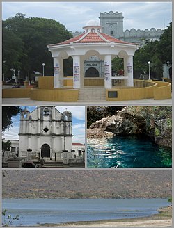
From the top: Park and kiosk, Church, Anda Mira Cave and Atescatempa Lagoon.
Flag of Jutiapa Department
Coat of arms of Jutiapa Department

Country Guatemala
CapitalJutiapa
Municipalities17
Government
 • TypeDepartmental
Area
 • Department of Guatemala3,219 km2 (1,243 sq mi)
Population
 (2018)[1]
 • Department of Guatemala488,395
 • Density150/km2 (390/sq mi)
 • Urban
249,754
 • Religions
Roman Catholicism Evangelicalism
Time zoneUTC-6

Jutiapa Department is a departmentofGuatemala that borders along El Salvador and the Pacific Ocean. The capital is the city of Jutiapa. As of 2018, it has a population of 488,395.[1] The department is divided into seventeen municipalities. Jutiapa is the country's southeasternmost department and officially the only department with no Mayan descendants native to the region. The main crops are sorghum, tobacco, onion and corn. The climate is dry. An important attraction is the cattle fair. It is at 405 m above sea level.

The population is ethnically "Ladino" (of European descent & non Mayan-indigenous), though in the northern regions of Jutiapa there are few descendants that once belonged to the Xinca population. The Xinca people were of non-Mayan descent.

The coat of arms contains the cornucopia symbolizing Jutiapa as the barn of the East, supplying Guatemala with most of the grain consumed by the people. The horse and the cow represent the cattle; the books stand for educational and cultural advances. In the background sits La Cruz hill, the firm guardian of the departmental chief town, with the tower or antenna of a Jutiapa radio station. Behind the hill float the clouds, the sky and the sun of Jutiapa, "The Sun City". This coat of arms is placed on the flag between two laurel branches symbolizing the daily triumphs of the sons of Jutiapa. The flag is mainly white, showing in its center the coat of arms adapted and adroned, between two laurel branches.

Municipalities[edit]

  1. Agua Blanca
  2. Asunción Mita
  3. Atescatempa
  4. Comapa
  5. Conguaco
  6. El Adelanto
  7. El Progreso
  8. Jalpatagua
  9. Jerez
  10. Jutiapa
  11. Moyuta
  12. Pasaco
  13. Quesada
  14. San José Acatempa
  15. Santa Catarina Mita
  16. Yupiltepeque
  17. Zapotitlán

References[edit]

  1. ^
  2. Jalapa
  • Chiquimula
  • Lake Güija
  • In El Salvador, Santa Ana and Ahuachapán
    1. ^ a b Citypopulation.de Population of departments in Guatemala

    External links[edit]

    Media related to Jutiapa Department at Wikimedia Commons

    14°16′58N 89°53′33W / 14.28278°N 89.89250°W / 14.28278; -89.89250


  • t
  • e

  • Retrieved from "https://en.wikipedia.org/w/index.php?title=Jutiapa_Department&oldid=1215602602"

    Categories: 
    Jutiapa Department
    Departments of Guatemala
    Guatemala geography stubs
    Hidden categories: 
    Pages with non-numeric formatnum arguments
    Pages using gadget WikiMiniAtlas
    Articles with short description
    Short description matches Wikidata
    Geography articles needing translation from Spanish Wikipedia
    Pages using infobox settlement with bad settlement type
    Pages using infobox settlement with no coordinates
    Commons category link from Wikidata
    Coordinates on Wikidata
    All stub articles


    This page was last edited on 26 March 2024, at 02:51 (UTC).

    Text is available under the Creative Commons Attribution-ShareAlike License 4.0; additional terms may apply. By using this site, you agree to the Terms of Use and Privacy Policy. Wikipedia® is a registered trademark of the Wikimedia Foundation, Inc., a non-profit organization.


    Privacy policy

    About Wikipedia

    Disclaimers

    Contact Wikipedia

    Code of Conduct

    Developers

    Statistics

    Cookie statement

    Mobile view


    Wikimedia Foundation
    Powered by MediaWiki