Jump to content


Main menu


Navigation  


Main page
Contents
Current events
Random article
About Wikipedia
Contact us
Donate


Contribute  


Help
Learn to edit
Community portal
Recent changes
Upload file


Search  


Create account

Log in


Create account
 Log in


Pages for logged out editors learn more  


Contributions
Talk


Contents


(Top)


1 History  


2 Improvements  


3 References  


4 External links  


A5300 road


Add links


Article
Talk


Read
Edit
View history


Tools


Actions  


Read
Edit
View history


General  


What links here
Related changes
Upload file
Special pages
Permanent link
Page information
Cite this page
Get shortened URL
Download QR code
Wikidata item


Print/export  


Download as PDF
Printable version


In other projects  


Wikimedia Commons


Appearance


Coordinates: 53°2302N 2°4759W / 53.38402°N 2.7998°W / 53.38402; -2.7998
 

From Wikipedia, the free encyclopedia
 

(Redirected from Knowsley Expressway)

A5300 shield

A5300
Knowsley Expressway north from Water Lane bridge.jpg
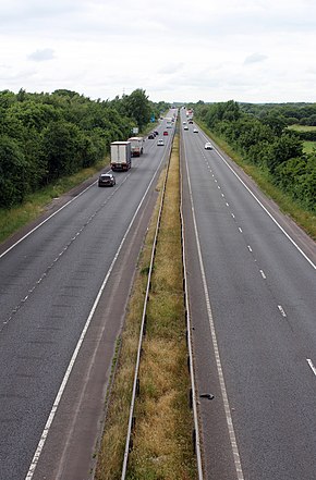
View towards Tarbock Island from Water Lane
Route information
Length3 mi (4.8 km)
Existed1996–present
Major junctions
From A562
To M62
Location
CountryUnited Kingdom
Road network

The A5300orKnowsley Expressway is a major road in Merseyside, England. It runs 3 miles (4.8 km) from its junction with the A562 to its junction with the M62, where it becomes the M57, providing a major north–south route through the borough. Along its course it crosses the Liverpool to Manchester Line Southern route. The road cost £47.3 million (equivalent to £114,933,825 in 2023)[1] when it was constructed during 1995–1996.

History[edit]

The idea of the extension dates back to the early 1970s, when Lancashire County Council was responsible for the region. When Knowsley Metropolitan Borough came into existence around 1986, they prioritised the need for construction of the route and in 1988, appointed consultants to examine the feasibility. Following traffic surveys, it was confirmed that a dual carriageway link road was needed. In total, nine alternate routes were assessed for consideration but many were rejected on environmental grounds. In 1989, Knowsley approached the Department for Transport regarding funding for their preferred route and arranged a 50% grant towards the cost. A public inquiry was needed due to 48 pieces of land needed from private owners to build the road on. Balfour Beatty were confirmed as the chosen constructor in the summer of 1993.[2]

Initial groundwork commenced in September 1993[3] and during early construction, ancient roof tiles dating back to 167 AD were unearthed alongside the path of the new road.[4]

The Expressway was constructed during 1995–1996, during which time over 24 hectares (59 acres) of woodland was planted along the embankments.[5] The road took around two and a half years to construct, which involved re-routing streams and planting around half a million trees.[6] The road was opened on 15 April 1996 by Eddie O'Hara MP and the first cars travelled along the road from 2pm the same day. It was estimated that the road would take around 35,000 vehicles each day.[7]

During development, Knowsley schools ran a competition for their school pupils to name the new road. The competition was won by a Halsnead Community Primary School pupil who named it the Knowsley Expressway.[8] As with other projects, the A5300 is a downgraded extension of a motorway, in this case the M57.

Improvements[edit]

In 2016, Knowsley Council announced a £5.3m investment to improve the expressway's southern junction with Speke Road, to focus on reducing congestion during peak time and ensure future demand can be met by expected economic growth.[9]

References[edit]

  1. ^ "Road Schemes 1998". Millbank Systems. 12 January 1998. Retrieved 9 June 2018.
  • ^ "£50m new route nearing completion". Liverpool Echo. 21 February 1996. p. 18.
  • ^ "Gearing up for the new link road". Runcorn Weekly News. 16 September 1993. p. 8.
  • ^ "Digging up the past". Runcorn Weekly News. 3 February 1994. p. 11.
  • ^ "Knowsley Expressway – A Knowsley Metropolitan Borough Council wood". Woodland Trust. Retrieved 14 April 2017.
  • ^ "MP gets set to open motorway link road". Liverpool Echo. 28 March 1996. p. 9.
  • ^ "Expressway to success". Liverpool Echo. 15 April 1996. p. 14.
  • ^ "School pupil names new road". Liverpool Echo. 12 April 1996. p. 16.
  • ^ "Knowsley Council has announced an investment of £5.3 million to improve the Knowsley Expressway and Speke Road junction". Liverpool Local Enterprise Partnership. 20 January 2016. Retrieved 14 April 2017.
  • External links[edit]

    53°23′02N 2°47′59W / 53.38402°N 2.7998°W / 53.38402; -2.7998


  • t
  • e

  • Retrieved from "https://en.wikipedia.org/w/index.php?title=A5300_road&oldid=1147766237"

    Categories: 
    Roads in England
    Roads in Merseyside
    England road stubs
    Hidden categories: 
    Pages using gadget WikiMiniAtlas
    Articles with short description
    Short description is different from Wikidata
    Use dmy dates from December 2022
    Use British English from January 2013
    Infobox road maps tracking category
    Infobox road instances in the United Kingdom
    Coordinates on Wikidata
    Commons category link from Wikidata
    All stub articles


    This page was last edited on 2 April 2023, at 01:31 (UTC).

    Text is available under the Creative Commons Attribution-ShareAlike License 4.0; additional terms may apply. By using this site, you agree to the Terms of Use and Privacy Policy. Wikipedia® is a registered trademark of the Wikimedia Foundation, Inc., a non-profit organization.


    Privacy policy

    About Wikipedia

    Disclaimers

    Contact Wikipedia

    Code of Conduct

    Developers

    Statistics

    Cookie statement

    Mobile view


    Wikimedia Foundation
    Powered by MediaWiki