Jump to content


Main menu


Navigation  


Main page
Contents
Current events
Random article
About Wikipedia
Contact us
Donate


Contribute  


Help
Learn to edit
Community portal
Recent changes
Upload file


Search  


Create account

Log in


Create account
 Log in


Pages for logged out editors learn more  


Contributions
Talk


Contents


(Top)


1 Suburbs and villages  


2 Kuppam River  


3 See also  


4 Image gallery  


5 Location  


6 See also  


Taliparamba West


Add links


Article
Talk


Read
Edit
View history


Tools


Actions  


Read
Edit
View history


General  


What links here
Related changes
Upload file
Special pages
Permanent link
Page information
Cite this page
Get shortened URL
Download QR code
Wikidata item


Print/export  


Download as PDF
Printable version


In other projects  


Wikimedia Commons


Appearance


Coordinates: 12°0259N 75°2051E / 12.049687°N 75.347414°E / 12.049687; 75.347414
 

From Wikipedia, the free encyclopedia
 

(Redirected from Kuppam taliparamba)

Taliparamba West
suburb
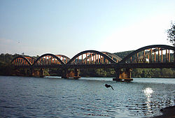
The historic Kuppam Bridge
Coordinates: 12°02′59N 75°20′51E / 12.049687°N 75.347414°E / 12.049687; 75.347414
Country India
StateKerala
DistrictKannur
Languages
 • OfficialMalayalam, English
Time zoneUTC+5:30 (IST)
ISO 3166 codeIN-KL
Vehicle registrationKL-59
Nearest cityTaliparamba
Lok Sabha constituencyKasargode

Taliparamba West is a group of suburbs and villages on the north and west of Taliparamba town. The locality is divided into two parts, south and north; South Kuppam is a part of Taliparamba municipality while North Kuppam, near Mukkunnu, is a part of Pariyaram village Panchayath.

During the 1960s and 1970s this village was a commercial center of spices. The National Highway-17 passes through Kuppam.

Suburbs and villages

[edit]
Kuppam river from the Mangalasssery Hills

Kuppam River

[edit]

Kuppam got its name from the Kuppam River, one of the 44 Rivers of Kerala, which originates from the hilly area of western Karnataka and flows into the Arabian Sea.

Once, waterways in the Kuppam River were the only mode of travel into the hilly areas of Kannur district. But since the construction of Kuppam Bridge, passenger boats have almost disappeared. The Kuppam Bridge was built in 1958 with British construction methods, which consists of five huge arches each side. The bridge is attractive for its construction style. A new bridge at Kuttiyeri Kadavu, connecting Kuttiyeri and Pariyaram opened in 2015.

See also

[edit]
[edit]

Location

[edit]

See also

[edit]
Retrieved from "https://en.wikipedia.org/w/index.php?title=Taliparamba_West&oldid=998241640"

Category: 
Taliparamba
Hidden categories: 
Pages using gadget WikiMiniAtlas
Articles lacking sources from December 2009
All articles lacking sources
Use dmy dates from February 2019
Use Indian English from February 2019
All Wikipedia articles written in Indian English
Articles with short description
Short description is different from Wikidata
Coordinates on Wikidata
Pages using infobox settlement with no map
Commons category link is on Wikidata


This page was last edited on 4 January 2021, at 13:14 (UTC).

Text is available under the Creative Commons Attribution-ShareAlike License 4.0; additional terms may apply. By using this site, you agree to the Terms of Use and Privacy Policy. Wikipedia® is a registered trademark of the Wikimedia Foundation, Inc., a non-profit organization.


Privacy policy

About Wikipedia

Disclaimers

Contact Wikipedia

Code of Conduct

Developers

Statistics

Cookie statement

Mobile view


Wikimedia Foundation
Powered by MediaWiki