Jump to content


Main menu


Navigation  


Main page
Contents
Current events
Random article
About Wikipedia
Contact us
Donate


Contribute  


Help
Learn to edit
Community portal
Recent changes
Upload file


Search  


Create account

Log in


Create account
 Log in


Pages for logged out editors learn more  


Contributions
Talk


Contents


(Top)


1 History  


2 Administration  


3 References  


4 External links  


Lak Si district


العربية
Cebuano
Davvisámegiella
Deutsch
Eesti
Français

িি ি
Italiano


Norsk bokmål

Русский
Scots

اردو
Tiếng Vit


Edit links


Article
Talk


Read
Edit
View history


Tools


Actions  


Read
Edit
View history


General  


What links here
Related changes
Upload file
Special pages
Permanent link
Page information
Cite this page
Get shortened URL
Download QR code
Wikidata item


Print/export  


Download as PDF
Printable version


In other projects  


Wikimedia Commons


Appearance


Coordinates: 13°5315N 100°3444E / 13.88750°N 100.57889°E / 13.88750; 100.57889
 

From Wikipedia, the free encyclopedia
 

(Redirected from Lak Si District)

Lak Si
หลักสี่
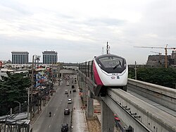
MRT Pink Line skytrain runs above Chaeng Watthana Road in the Lak Si area
Khet location in Bangkok
Coordinates: 13°53′15N 100°34′44E / 13.88750°N 100.57889°E / 13.88750; 100.57889
CountryThailand
ProvinceBangkok
SeatThung Song Hong
Khwaeng2
Khet established21 November 1997
Area
 • Total22.841 km2 (8.819 sq mi)
Population
 (2017)
 • Total104,701[1]
 • Density4,583.90/km2 (11,872.2/sq mi)
Time zoneUTC+7 (ICT)
Postal code
10210
Geocode1041

Lak Si (Thai: หลักสี่, pronounced [làk sìː]) is one of the 50 districts (khet) of Bangkok, Thailand. It is bounded by (from the north clockwise): Don Mueang, Bang Khen and Chatuchak of Bangkok; Mueang Nonthaburi district and Pak Kret districtofNonthaburi province.

History[edit]

The name Lak Si means 'fourth milestone'. The community here was called Lak Si because it is at the fourth milestone of Khlong Prem Prachakon (คลองเปรมประชากร) (canal) dug during King Chulalongkorn's reign linking Bangkok to Bang Pa-in. Lak Si became a district on 21 November 1997, separating from Don Mueang District.

Administration[edit]

The district is divided into two sub-districts (khwaeng).

No. Name Thai Area
(km2)
Map
1.
Thung Song Hong ทุ่งสองห้อง
16.886
Map
2.
Talat Bang Khen ตลาดบางเขน
5.955
Total
22.841

References[edit]

  1. ^ "Population and House Report for Year 2017 (see page 2 for data of this district)". Department of Provincial Administration, Ministry of Internal Affairs. Retrieved 1 April 2018. (Search page)

External links[edit]


  • t
  • e

  • Retrieved from "https://en.wikipedia.org/w/index.php?title=Lak_Si_district&oldid=1189679739"

    Categories: 
    Lak Si district
    Districts of Bangkok
    Bangkok stubs
    Hidden categories: 
    Pages using gadget WikiMiniAtlas
    Use dmy dates from August 2023
    Articles with short description
    Short description is different from Wikidata
    Coordinates on Wikidata
    Articles containing Thai-language text
    Pages with Thai IPA
    All stub articles


    This page was last edited on 13 December 2023, at 09:16 (UTC).

    Text is available under the Creative Commons Attribution-ShareAlike License 4.0; additional terms may apply. By using this site, you agree to the Terms of Use and Privacy Policy. Wikipedia® is a registered trademark of the Wikimedia Foundation, Inc., a non-profit organization.


    Privacy policy

    About Wikipedia

    Disclaimers

    Contact Wikipedia

    Code of Conduct

    Developers

    Statistics

    Cookie statement

    Mobile view


    Wikimedia Foundation
    Powered by MediaWiki