Jump to content


Main menu


Navigation  


Main page
Contents
Current events
Random article
About Wikipedia
Contact us
Donate


Contribute  


Help
Learn to edit
Community portal
Recent changes
Upload file


Search  


Create account

Log in


Create account
 Log in


Pages for logged out editors learn more  


Contributions
Talk


Contents


(Top)


1 Name  


2 Notes and references  


3 External links  


Lake Letas


Беларуская
Български
Чӑвашла
Cebuano
Deutsch
Español
Français
Hrvatski
Bahasa Indonesia
Lietuvių
Polski
Русский
Українська


Edit links


Article
Talk


Read
Edit
View history


Tools


Actions  


Read
Edit
View history


General  


What links here
Related changes
Upload file
Special pages
Permanent link
Page information
Cite this page
Get shortened URL
Download QR code
Wikidata item


Print/export  


Download as PDF
Printable version


Appearance


Coordinates: 14°17S 167°32E / 14.283°S 167.533°E / -14.283; 167.533
 

From Wikipedia, the free encyclopedia
 

(Redirected from Lake Letes)

Lake Letas
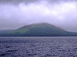
Lake Letas with Mount Gharat
Location in Vanuatu
Location in Vanuatu

Lake Letas

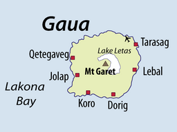
Map of Gaua, with Lake Letas in center
LocationGaua
Coordinates14°17′S 167°32′E / 14.283°S 167.533°E / -14.283; 167.533
Typecrater lake
Primary outflowsSiri Waterfall
Basin countriesVanuatu
Max. length6.3 km (3.9 mi)
Max. width3.6 km (2.2 mi)
Surface area19 km2 (7.3 sq mi)
Average depth42 m (138 ft)
Max. depth119 m (390 ft)[1]
Water volume800×10^6 m3 (650,000 acre⋅ft)[1]
Surface elevation418 m (1,371 ft)[2]

Ramsar Wetland

Official nameLake Letes
Designated15 September 2023
Reference no.2524[3]

Lake Letas is the largest lakeinVanuatu, located in the center of the volcanic island of Gaua of the Banks Islands in northern Vanuatu. The place submitted an application to be considered an UNESCO World Heritage Site in 2004, and has been listed as a protected Ramsar site since 2023.[3]

The volcanic lake is U-shaped, surrounding Mount Gharat on all sides except southwest. It is about 9 km long (north to south) and about 6 km wide, with an area of 19 km2. It is situated in the center of the 20 km diameter island; the lake rests 418 meters above sea level[2] and it is 119 meters deep.[1] It is a fresh water lake with a temperature of 32 °C, where only eels and shrimps can survive.[4] The water in the lake is not very clear, but has a greenish color. Water constantly flows out of the lake at a natural overflow located on the eastern side of the lake. The water flows about 3 km east to Siri Waterfall and then another 3 km through rivers NamangorBe Solomul before it reaches the sea.

2013 Satellite view of Gaua I., with Lake Letas and Mt Gharat in its center

Local people say there is a canoe at the top of the lake which is used to cross the lake from the eastern side to get to Mount Gharat. The canoe is sometimes located on the eastern edge of the lake (near the water overflow), or sometimes on the north-eastern edge of the lake (nearest Gaua Airport).

A rough estimate of the water flow rate out of the lake (during the dry season month of August 2006) was approximately 3 cubic meters per second.

In the 1980s it was suggested that the lake could be used as a resource for power generation to supply industrial developments but later the Tourism Council of the South Pacific has suggested that the lake should be included in Vanuatu's protected area system. The Department of Physical Planning and Environment is currently considering the status of protected area to the lake.

Name[edit]

The name Letas [leˈtas] comes from the Mota language, which missionaries used to name most places within the Banks Islands. Names in other local languages include Nume Le Tes [lɛˈtɛs], Dorig Bētās [ᵐbɪˈtaːs], Koro Bētäs [ᵐbɪˈtɛ͡as], Olrat Lē Tas [lɪˈtas], and Lakon Ēpitäh [ɪpiˈtæh]. All of these terms contain a reflex of Proto-Torres–Banks *tasi, meaning "sea". Additionally, the Dorig and Koro forms contain an initial component that can be reconstructed as *ᵐbei, meaning "water".

Notes and references[edit]

  1. ^ a b c (in French) Thery Laurent, Charley Douglas, Lardy Michel, Tari Joseph, 1995, Bathymétrie du lac Létas, Ile de Gaua (Banks), Vanuatu. Port-Vila: ORSTOM.
  • ^ a b Bani, Ernest, & David Esrom. 1993. Republic of Vanuatu Archived 2010-07-17 at the Wayback Machine. In A directory of wetlands in Oceania, ed. by D. A. Scott. Slimbridge, UK: International Waterfowl and Wetlands Research Bureau, 397-420.
  • ^ a b "Lake Letes". Ramsar Sites Information Service. Retrieved 20 October 2023.
  • ^ Mourgues, Adrien. 2005. Republic of Vanuatu Environment Profile[permanent dead link]. Port-Vila. 74 pp.
  • External links[edit]


    Retrieved from "https://en.wikipedia.org/w/index.php?title=Lake_Letas&oldid=1190708744"

    Categories: 
    Volcanic crater lakes
    Lakes of Vanuatu
    Ramsar sites in Vanuatu
    Hidden categories: 
    Pages using gadget WikiMiniAtlas
    Articles with French-language sources (fr)
    Webarchive template wayback links
    All articles with dead external links
    Articles with dead external links from February 2020
    Articles with permanently dead external links
    Articles with short description
    Short description is different from Wikidata
    Pages using infobox body of water with auto short description
    Coordinates on Wikidata
    Pages with undetermined IPA


    This page was last edited on 19 December 2023, at 11:04 (UTC).

    Text is available under the Creative Commons Attribution-ShareAlike License 4.0; additional terms may apply. By using this site, you agree to the Terms of Use and Privacy Policy. Wikipedia® is a registered trademark of the Wikimedia Foundation, Inc., a non-profit organization.


    Privacy policy

    About Wikipedia

    Disclaimers

    Contact Wikipedia

    Code of Conduct

    Developers

    Statistics

    Cookie statement

    Mobile view


    Wikimedia Foundation
    Powered by MediaWiki