Jump to content


Main menu


Navigation  


Main page
Contents
Current events
Random article
About Wikipedia
Contact us
Donate


Contribute  


Help
Learn to edit
Community portal
Recent changes
Upload file


Search  


Create account

Log in


Create account
 Log in


Pages for logged out editors learn more  


Contributions
Talk


Contents


(Top)


1 Formation  


2 References  


3 External links  


Sarez Lake


Беларуская
Чӑвашла
Cebuano
Čeština
Deutsch
Español
Esperanto
Euskara
فارسی
Français
Հայերեն
Italiano

Қазақша
Latviešu
Lietuvių
مصرى

Oʻzbekcha / ўзбекча
Polski
Português
Русский
Српски / srpski
Тоҷикӣ
Українська
Tiếng Vit


Edit links


Article
Talk


Read
Edit
View history


Tools


Actions  


Read
Edit
View history


General  


What links here
Related changes
Upload file
Special pages
Permanent link
Page information
Cite this page
Get shortened URL
Download QR code
Wikidata item


Print/export  


Download as PDF
Printable version


In other projects  


Wikimedia Commons


Appearance


Coordinates: 38°1206N 72°4527E / 38.20167°N 72.75750°E / 38.20167; 72.75750
 

From Wikipedia, the free encyclopedia
 

(Redirected from Lake Sarez)

Sarez Lake
Usoi Dam separating Sarez (right) and Shadau (left) lakes
Sarez Lake is located in Tajikistan
Sarez Lake

Sarez Lake

Coordinates38°12′06N 72°45′27E / 38.20167°N 72.75750°E / 38.20167; 72.75750
Primary inflowsMurghab River
Primary outflowsMurghab River
Basin countriesTajikistan
Max. length75.8 kilometres (47.1 mi)
Max. width3.3 kilometres (2.1 mi)
Surface area79.7 square kilometres (30.8 sq mi)
Average depth201.8 metres (662 ft)
Max. depth505 metres (1,657 ft)
Water volume16.074 cubic kilometres (3.856 cu mi)
Shore length1162 kilometres (101 mi)
Surface elevation3,263 metres (10,705 ft)
1 Shore length is not a well-defined measure.
Satellite photo of the western end of Sarez Lake showing the Usoi Dam and the smaller Shadau Lake

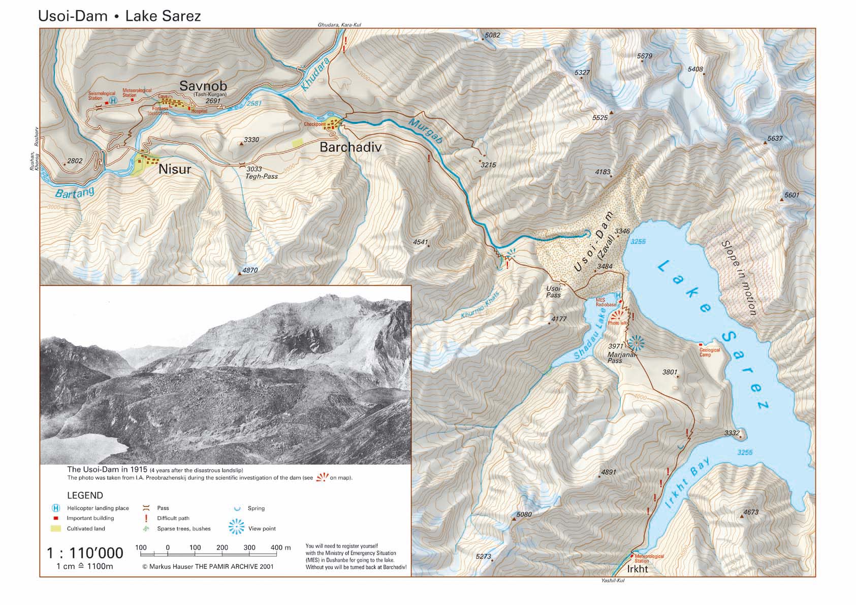
Sarez Lake (Russian: Сарезское озеро; Tajik: Сарез кӯл, romanizedSarez Kūl) is a lake in Rushon DistrictofGorno-Badakhshan province, Tajikistan. Length about 75.8 kilometres (47.1 mi), depth few hundred meters, water surface elevation about 3,263 metres (10,705 ft) above sea level and volume of water is more than 16 cubic kilometres (3.8 cu mi). The mountains around rise more than 2,300 metres (7,500 ft) above the lake level.

The lake formed in 1911, after a great earthquake, when the Murghab River was blocked by a big landslide. Scientists believe that the landslide dam formed by the earthquake, known as the Usoi Dam, is unstable given local seismicity, and that the terrain below the lake is in danger of catastrophic flood if the dam were to fail during a future earthquake.[1] The Usoi Dam wall survived a localised 7.2 magnitude earthquake, the 2015 Tajikistan earthquake, on the 7th December 2015 with no visible signs of deterioration.

Shadau Lake is a small water body southwest of the Usoi Dam and west of Sarez Lake.[2]

Formation

[edit]

The formation of Sarez Lake is described in the book by Middleton and Thomas:[3]

The 1911 Sarez earthquake, estimated at 6.5-7.0 on the Richter scale, occurred about midnight, 5–6 February 1911 (old style). Deaths were estimated at 302. The landslide was 2.2 billion cubic meters and formed the Usoi Dam which is approx. 5 kilometres (3.1 mi) long, 3.2 kilometres (2.0 mi) wide and up to 567 metres (1,860 ft) high, the tallest natural dam in the world. Usoi was a village buried under the landslide. The area was so isolated and the destruction of mountain tracks so complete that it took six weeks before word reached the Russian posts at Murghab and Khorog.

In 1968 a landslide caused two-meter-high waves in the lake. A 1997 conference in Dushanbe concluded that the dam was unstable and might collapse if there were another powerful earthquake. A 2004 study by the World Bank held that the dam was stable. The principal danger seems to be a partially detached mass of rock of about 3 cubic kilometres that could break loose and fall into the lake. Since the valley below the dam is so narrow, any flood would be very destructive. The result of a global risk analysis carried out by STUCKY for the World Bank was presented at the 2002 IAHR Symposium in St Petersburg [1] and at the 2006 International Congress on Large Dams [2] in Barcelona.

References

[edit]
  1. ^ Bolt, B.A., W.L. Horn, G.A. Macdonald and R.F. Scott, (1975) Geological hazards: earthquakes, tsunamis, volcanoes, avalanches, landslides, floods Springer-Verlag, New York, ISBN 0-387-06948-8
  • ^ "Shadau Lake on 1:110'000 map" (JPG).
  • ^ Robert Middleton and Huw Thomas, Tajikistan and the High Pamirs, Odyssey, 2008, ISBN 962-217-773-5, ISBN 978-962-217-773-4
  • [edit]
    Retrieved from "https://en.wikipedia.org/w/index.php?title=Sarez_Lake&oldid=1216595021"

    Categories: 
    Lakes of Tajikistan
    Gorno-Badakhshan Autonomous Region
    Landslide-dammed lakes
    Landslides in Asia
    Natural disasters in Tajikistan
    Landslides in 1911
    Hidden categories: 
    Pages using gadget WikiMiniAtlas
    Articles with short description
    Short description is different from Wikidata
    Coordinates on Wikidata
    Articles using infobox body of water without alt
    Articles using infobox body of water without pushpin map alt
    Articles using infobox body of water without image bathymetry
    Articles containing Russian-language text
    Articles containing Tajik-language text
    Webarchive template wayback links


    This page was last edited on 31 March 2024, at 23:13 (UTC).

    Text is available under the Creative Commons Attribution-ShareAlike License 4.0; additional terms may apply. By using this site, you agree to the Terms of Use and Privacy Policy. Wikipedia® is a registered trademark of the Wikimedia Foundation, Inc., a non-profit organization.


    Privacy policy

    About Wikipedia

    Disclaimers

    Contact Wikipedia

    Code of Conduct

    Developers

    Statistics

    Cookie statement

    Mobile view


    Wikimedia Foundation
    Powered by MediaWiki