Jump to content


Main menu


Navigation  


Main page
Contents
Current events
Random article
About Wikipedia
Contact us
Donate


Contribute  


Help
Learn to edit
Community portal
Recent changes
Upload file


Search  


Create account

Log in


Create account
 Log in


Pages for logged out editors learn more  


Contributions
Talk


Contents


(Top)


1 History  


2 Gallery  


3 See also  


4 References  


5 External links  


Leadenhall Market


Afrikaans
Čeština
Dansk
Deutsch
Español
Euskara
Français
Gaeilge

עברית
Lëtzebuergesch
Nederlands

Norsk bokmål
Norsk nynorsk
Русский
Suomi


Edit links


Article
Talk


Read
Edit
View history


Tools


Actions  


Read
Edit
View history


General  


What links here
Related changes
Upload file
Special pages
Permanent link
Page information
Cite this page
Get shortened URL
Download QR code
Wikidata item


Print/export  


Download as PDF
Printable version


In other projects  


Wikimedia Commons


Appearance


Coordinates: 51°3046N 0°0501W / 51.5128°N 0.0835°W / 51.5128; -0.0835
 

From Wikipedia, the free encyclopedia
 

(Redirected from Leadenhall)

Leadenhall Market
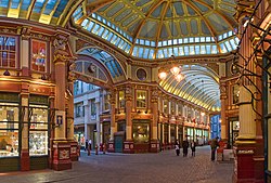
The central interior of Leadenhall Market
Map
LocationCity of London, England
Coordinates51°30′46N 0°05′01W / 51.5128°N 0.0835°W / 51.5128; -0.0835
AddressGracechurch Street, London EC3V 1LT
Opening date14th century
Websiteleadenhallmarket.co.uk Edit this at Wikidata

East Arcade of Leadenhall Market

Leadenhall Market is a covered market in London, England, located on Gracechurch Street but with vehicular access also available via Whittington Avenue to the north and Lime Street to the south and east, and additional pedestrian access via a number of narrow passageways.

It is one of the oldest markets in London, dating from the 14th century, and is located in the historic centre of the City of London financial district.

History

[edit]

The market dates from the 14th century and is said to derive its name from Leather-hall, though it is disputable.[1] The early history of Leaden Hall involves the Mayor (1446), Simon Eyre. According to John Stow, "Eyre, a draper built Leaden Hall for a common garner of corn for the use of this city".[2][3]

The Market is typically open weekdays from 10 am until 6 pm, and primarily sells fresh food; among the vendors there are cheesemongers, butchers and florists. Originally a meat, game and poultry market, it stands on what was the centre of Roman London.[4] A number of commercial retailers are also located in the market, including clothes shops. The Lamb Tavern, dating from 1780, is a traditional gathering place for insurance industry workers, many of whom work at Lloyd's of London adjacent to Leadenhall Market.[5][6]

The ornate roof structure, painted green, maroon and cream, and cobbled floors of the current structure, designed in 1881 by Sir Horace Jones (who was also the architect of Billingsgate and Smithfield Markets), make Leadenhall Market a tourist attraction.[4]

The main entrance to the market is on Gracechurch Street. The double height entrance is flanked by tall, narrow gabled red brick and Portland stone blocks in a 17th-century Dutch style. The adjacent buildings to the south have a continuous retail frontage which is punctuated by narrow entrances to pedestrian ways into the market.

Between 1990 and 1991 the market received a dramatic redecoration which improved its appearance, enhancing its architectural character and detail. The redecoration scheme received a special mention in the Civic Trust Awards in 1994. The market is a Grade II* listed building, being listed in 1972.[7]

It was used to represent the area of London near the Leaky Cauldron and Diagon Alley in the film Harry Potter and the Philosopher's Stone (2001) and is featured in the films The Imaginarium of Doctor Parnassus (2009), Hereafter (2010), Brannigan (1975), Hidden City (1987) and Love Aaj Kal (2009). It was also used in the music video for the 1991 Erasure song "Love to Hate You".

Leadenhall Market formed part of the marathon course of the 2012 Olympic Games; runners passed through the market from Whittington Avenue to Lime Street.[8][9]

Furthermore, it is featured in Mario Kart Tour and Mario Kart 8 Deluxe as part of the London Loop Course .[10]

[edit]

See also

[edit]

References

[edit]
  1. ^ Wedgwood, Hensleigh (1855). "On False Etymologies". Transactions of the Philological Society (6): 67.
  • ^ J. Stow, A Svrvay of London (John Windel, Printer to the Citie of London, 1603), p. 155-6 (Google).
  • ^ "Honour of Citizens and worthines of men | British History Online". www.british-history.ac.uk.
  • ^ a b Leadenhall Market Archived 31 October 2012 at the Wayback Machine (City of London) accessed 30 September 2009
  • ^ Merlin, Chip. "Lloyd's Marketplace of Interaction and Lloyd's Pubs". Merlin Law Group. Retrieved 9 May 2024.
  • ^ Finch, Gavin. "The Old Daytime-Drinking, Sexual-Harassing Ways Are Thriving at Lloyd's". Bloomberg.com. Retrieved 9 May 2024.
  • ^ Stuff, Good. "Leadenhall Market with Subsidiary Numbering, City of London, London, London". britishlistedbuildings.co.uk.
  • ^ "Men's Marathon - Olympic Athletics Course Map | London 2012". Archived from the original on 30 April 2013. Retrieved 30 May 2015.
  • ^ "Women's Marathon - Olympic Athletics Course Map | London 2012". Archived from the original on 2 May 2013. Retrieved 30 May 2015.
  • ^ Stuff, Good. "London Loop , City of London". mariowiki.com.
  • [edit]
    Retrieved from "https://en.wikipedia.org/w/index.php?title=Leadenhall_Market&oldid=1223052303"

    Categories: 
    Grade II* listed buildings in the City of London
    Retail markets in London
    Tourist attractions in the City of London
    Shopping centres in the City of London
    Hidden categories: 
    Pages using gadget WikiMiniAtlas
    Webarchive template wayback links
    Articles with short description
    Short description is different from Wikidata
    Infobox mapframe without OSM relation ID on Wikidata
    Coordinates on Wikidata
    Use dmy dates from November 2014
    Use British English from November 2014
    Articles containing Hindi-language text
    Commons category link is on Wikidata
    Pages using the Kartographer extension


    This page was last edited on 9 May 2024, at 15:53 (UTC).

    Text is available under the Creative Commons Attribution-ShareAlike License 4.0; additional terms may apply. By using this site, you agree to the Terms of Use and Privacy Policy. Wikipedia® is a registered trademark of the Wikimedia Foundation, Inc., a non-profit organization.


    Privacy policy

    About Wikipedia

    Disclaimers

    Contact Wikipedia

    Code of Conduct

    Developers

    Statistics

    Cookie statement

    Mobile view


    Wikimedia Foundation
    Powered by MediaWiki