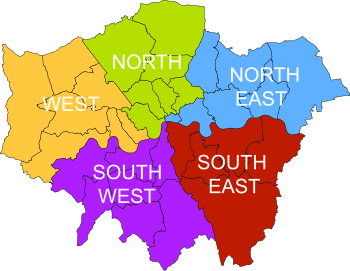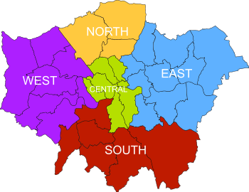

| London sub-regions | |
|---|---|
 | |
| Location | London |
| Found in | Greater London |
| Created |
|
| Number | 5 (as of 2011) |
| Populations | 1–4 million |
| Subdivisions | |
Greater London is divided into five sub-regions for the purposes of the London Plan. The boundaries of these areas were amended in 2008 and 2011 and their role in the implementation of the London Plan has varied with each iteration.
Sub-regions are a feature of the London Plan intended to encourage partnership working across London borough boundaries.[1]
From 2004 to 2008, the sub-regions were initially the same as the Learning and Skills Council areas set up in 1999.[2] These 2004–2008 sub-regions each had a Sub-Regional Development Framework.[3] The sub-regions were revised in February 2008 as part of the Further Alterations to the London Plan.[4] The 2008–2011 sub-regions, each had its own Sub-regional Implementation Framework.[5] In 2011, the sub-regions were revised again. The 2011 sub-regions are used for statutory monitoring, engagement and resource allocation.[6] The sub-regions have remained static since 2011, unchanged in the 2016 published plan and 2019 draft plan.
| Sub-region | London boroughs[7] | Population (2001) | 
|
|---|---|---|---|
| Central | Camden, Islington, Kensington and Chelsea, Southwark, Wandsworth, Westminster | 1,525,000 | |
| East | Barking and Dagenham, Bexley, City of London, Greenwich, Hackney, Havering, Lewisham, Newham, Redbridge, Tower Hamlets | 1,991,000 | |
| North | Barnet, Enfield, Haringey, Waltham Forest | 1,042,000 | |
| South | Bromley, Croydon, Kingston upon Thames, Lambeth, Merton, Richmond upon Thames, Sutton | 1,329,000 | |
| West | Brent, Ealing, Hammersmith and Fulham, Harrow, Hillingdon, Hounslow | 1,421,000 |
| Sub-region | London boroughs | Population | Jobs | 
|
|---|---|---|---|---|
| North East[8] | Barking and Dagenham, City of London, Havering, Newham, Redbridge, Tower Hamlets, Waltham Forest | 1.4 million | 900,000 | |
| North[9] | Barnet, Camden, Enfield, Hackney, Haringey, Islington, Westminster | 1.7 million | 1.5 million | |
| South East[10] | Bexley, Bromley, Greenwich, Lewisham, Southwark | 1.3 million | 500,000 | |
| South West[11] | Croydon, Kingston upon Thames, Lambeth, Merton, Richmond upon Thames, Sutton, Wandsworth | 1.6 million | 730,000 | |
| West[12] | Brent, Ealing, Hammersmith and Fulham, Harrow, Hillingdon, Hounslow, Kensington and Chelsea | 1.6 million | 900,000 |
| Sub-region | London boroughs[6] | Area | 
|
|---|---|---|---|
| Central | Camden, City of London, Kensington and Chelsea, Islington, Lambeth, Southwark, Westminster | 13,136.02 hectares (50.7185 sq mi) | |
| East | Barking and Dagenham, Bexley, Greenwich, Hackney, Havering, Lewisham, Newham, Redbridge, Tower Hamlets, Waltham Forest | 47,673.77 hectares (184.0695 sq mi) | |
| North | Barnet, Enfield, Haringey | 19,853.67 hectares (76.6554 sq mi) | |
| South | Bromley, Croydon, Kingston upon Thames, Merton, Sutton, Wandsworth | 44,936.52 hectares (173.5009 sq mi) | |
| West | Brent, Ealing, Hammersmith and Fulham, Harrow, Richmond upon Thames, Hillingdon, Hounslow | 33,868.62 hectares (130.7675 sq mi) |
| Borough | 2004–2008 | 2008–2011 | 2011–present |
|---|---|---|---|
| City of London | East | North East | Central |
| Barking and Dagenham | East | North East | East |
| Barnet | North | North | North |
| Bexley | East | South East | East |
| Brent | West | West | West |
| Bromley | South | South East | South |
| Camden | Central | North | Central |
| Croydon | South | South West | South |
| Ealing | West | West | West |
| Enfield | North | North | North |
| Greenwich | East | South East | East |
| Hackney | East | North | East |
| Hammersmith and Fulham | West | West | West |
| Haringey | North | North | North |
| Harrow | West | West | West |
| Havering | East | North East | East |
| Hillingdon | West | West | West |
| Hounslow | West | West | West |
| Islington | Central | North | Central |
| Kensington and Chelsea | Central | West | Central |
| Kingston upon Thames | South | South West | South |
| Lambeth | Central | South West | Central |
| Lewisham | East | South East | East |
| Merton | South | South West | South |
| Newham | East | North East | East |
| Redbridge | East | North East | East |
| Richmond upon Thames | South | South West | West |
| Southwark | Central | South East | Central |
| Sutton | South | South West | South |
| Tower Hamlets | East | North East | East |
| Waltham Forest | North | North East | East |
| Wandsworth | Central | South West | South |
| Westminster | Central | North | Central |