Jump to content


Main menu


Navigation  


Main page
Contents
Current events
Random article
About Wikipedia
Contact us
Donate


Contribute  


Help
Learn to edit
Community portal
Recent changes
Upload file


Search  


Create account

Log in


Create account
 Log in


Pages for logged out editors learn more  


Contributions
Talk


Contents


(Top)


1 Geography  


2 Administrative divisions  


3 Climate change concerns  


4 Universities  


5 Hospitals  


6 References  


7 External links  


Long An province


Acèh
العربية
تۆرکجه
 / Bân-lâm-gú
Български
Cebuano
Čeština
Deutsch
Español
فارسی
Français
/Hak-kâ-ngî

ि
Bahasa Indonesia
Italiano
Kapampangan
Kiswahili
 / Mìng-dĕ̤ng-nḡ
Nederlands

Nordfriisk

Polski
Português
Română
Русский
Српски / srpski
Suomi
Svenska

Тоҷикӣ
Türkçe
Українська
اردو
Tiếng Vit
Winaray


Zazaki


Edit links


Article
Talk


Read
Edit
View history


Tools


Actions  


Read
Edit
View history


General  


What links here
Related changes
Upload file
Special pages
Permanent link
Page information
Cite this page
Get shortened URL
Download QR code
Wikidata item


Print/export  


Download as PDF
Printable version


In other projects  


Wikimedia Commons


Appearance


Coordinates: 10°40N 106°10E / 10.667°N 106.167°E / 10.667; 106.167
 

From Wikipedia, the free encyclopedia
 

(Redirected from Long An Province)

Long An province
Tỉnh Long An
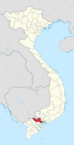
Location of Long An within Vietnam
Map
Coordinates: 10°40′N 106°10′E / 10.667°N 106.167°E / 10.667; 106.167
Country Vietnam
RegionMekong Delta
CapitalTân An
Government
 • People's Council ChairTrương Văn Tiếp
 • People's Committee ChairDương Quốc Xuân
Area
 • Total4,494.79 km2 (1,735.45 sq mi)
Population
 (2021)[2]
 • Total1,763,754
 • Density390/km2 (1,000/sq mi)
Demographics
 • EthnicitiesVietnamese, Hoa, Khmer
GDP[3]
 • TotalVND 168.108 trillion
US$ 7.053 billion (2023)
Time zoneUTC+7 (ICT)
Calling code72
ISO 3166 codeVN-41
Websiteeng.longan.gov.vn
Tôn Thạnh Temple, an ancient temple in Long An

Long An (Vietnamese: [lawŋ͡m˧˧ ʔaːn˧˧] ) is a province in the Mekong Delta region of southern Vietnam. The provincial capital is Tân An, and other major districts include Kiến Tường, Bến Lức, Cần Giuộc and Đức Hòa. There are 15 districts within the province (included 1 provincial capital city and 1 district-level town).[4]

The region is between Ho Chi Minh City in the north and the Mekong Delta. Because of its low lying geography, it is susceptible to sea level rise caused by climate change.

Geography[edit]

Long An is situated in an advantageous position in the Southern Key Economic Region of Vietnam. It serves as a bridge between Ho Chi Minh City in the north and 12 provinces in the Mekong Delta in the south. The province also has Cambodia to its west and the East Sea (South China Sea) to its east.

Long An is a low-lying coastal region, and therefore some areas of it are subject to flooding during the rainy season, which lasts from the beginning of August until November.

The province has numerous rivers. Two of the main ones are the Vàm Cỏ Đông and Vàm Cỏ Tay, which connect with the Tiền to form a larger river system. Another important river in the region is the Soài Rạp.

Administrative divisions[edit]

Long An is subdivided into 15 district-level sub-divisions:

They are further subdivided into 14 commune-level towns (or townlets), 166 communes, and 12 wards.

Climate change concerns[edit]

Being a low-lying coastal region, Long An is particularly susceptible to floods resulting from rises in sea level due to climate change. The Climate Change Research InstituteatCan Tho University (Trường Đại học Cần Thơ), in studying the possible consequences of climate change, has predicted that 49% of Long An province is expected to be flooded if sea levels rise by one meter.[5]

Universities[edit]

Long An is home to two large universities:

Hospitals[edit]

136C ĐT827, P7, Tân An, Long An 82100, Vietnam

References[edit]

  1. ^ Biểu số 4.6: Hiện trạng sử dụng đất vùng Đồng Bằng Sông Cửu Long năm 2022 [Table 4.6: Current land use status in the Mekong Delta in 2022] (PDF) (Decision 3048/QĐ-BTNMT) (in Vietnamese). Ministry of Natural Resources and Environment (Vietnam). 18 October 2023. – the data in the report are in hectares, rounded to integers
  • ^ Statistical Handbook of Vietnam 2014 Archived 2015-07-06 at the Wayback Machine, General Statistics Office Of Vietnam
  • ^ "Long An: Economic increase ranks 13th in the country".
  • ^ Long An Government
  • ^ Mekong Delta: more flood and drought Archived 2010-05-05 at the Wayback Machine. VietnamNet Bridge. March 19, 2009.
  • External links[edit]


    Retrieved from "https://en.wikipedia.org/w/index.php?title=Long_An_province&oldid=1223712740"

    Categories: 
    Long An province
    Provinces of Vietnam
    Hidden categories: 
    Pages using gadget WikiMiniAtlas
    Pages using the Phonos extension
    CS1 Vietnamese-language sources (vi)
    Webarchive template wayback links
    Articles with short description
    Short description matches Wikidata
    Articles needing additional references from December 2009
    All articles needing additional references
    Short description is different from Wikidata
    Coordinates on Wikidata
    Pages with Vietnamese IPA
    Pages including recorded pronunciations
    Articles containing Vietnamese-language text
    Articles with Vietnamese-language sources (vi)
    Official website different in Wikidata and Wikipedia
    Commons category link is on Wikidata
    Articles with VIAF identifiers
    Articles with WorldCat Entities identifiers
    Articles with J9U identifiers
    Articles with LCCN identifiers
    Articles with MusicBrainz area identifiers
    Pages using the Kartographer extension


    This page was last edited on 13 May 2024, at 21:35 (UTC).

    Text is available under the Creative Commons Attribution-ShareAlike License 4.0; additional terms may apply. By using this site, you agree to the Terms of Use and Privacy Policy. Wikipedia® is a registered trademark of the Wikimedia Foundation, Inc., a non-profit organization.


    Privacy policy

    About Wikipedia

    Disclaimers

    Contact Wikipedia

    Code of Conduct

    Developers

    Statistics

    Cookie statement

    Mobile view


    Wikimedia Foundation
    Powered by MediaWiki