Jump to content


Main menu


Navigation  


Main page
Contents
Current events
Random article
About Wikipedia
Contact us
Donate


Contribute  


Help
Learn to edit
Community portal
Recent changes
Upload file


Search  


Create account

Log in


Create account
 Log in


Pages for logged out editors learn more  


Contributions
Talk


Contents


(Top)


1 History  


2 Tourism  


3 References  


4 External links  


Singkhon Pass


Cebuano
Svenska


Edit links


Article
Talk


Read
Edit
View history


Tools


Actions  


Read
Edit
View history


General  


What links here
Related changes
Upload file
Special pages
Permanent link
Page information
Cite this page
Get shortened URL
Download QR code
Wikidata item


Print/export  


Download as PDF
Printable version


In other projects  


Wikimedia Commons


Appearance


Coordinates: 11°4722N 99°3827E / 11.78944°N 99.64083°E / 11.78944; 99.64083
 

From Wikipedia, the free encyclopedia
 

(Redirected from Maw Daung)

Singkhon Pass
ด่านสิงขร
Maw Daung
Border checkpoint, Singkhon Pass
Elevation245 m (804 ft)[1]
LocationMyanmarThailand border
RangeTenasserim Hills
Coordinates11°47′22N 99°38′27E / 11.78944°N 99.64083°E / 11.78944; 99.64083
Dan Sing Khon is located in Thailand
Dan Sing Khon

Dan Sing Khon

Location of Singkhon Pass on the Myanmar/Thailand border

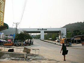
Singkhon Pass Myanmar-Thailand border post. Border Patrol Police office.
Road sign on Thailand Road 1039 near Singkhon Pass

Singkhon Pass[2] (Thai: ด่านสิงขร), also referred to as Sing Khon and as Maw Daung after the name of the Burmese town west of the border,[3] is a pass across the Tenasserim Hills on the border between Thailand and Myanmar, at an elevation of 245 metres (804 ft). The pass is close to the narrowest point of ThailandinKhlong Wan (คลองวาฬ) subdistrict, Mueang Prachuap Khiri Khan District, Prachuap Khiri Khan Province.

History[edit]

Singkhon pass was important during the wars between Siam and the Burmese, and also during World War II, when the Mergui Road was constructed by the Japanese invaders. The pass, on Thai Hwy 1039, about 14 km (8.7 mi) to the west of its junction with Thailand Route 41, was formerly closed, but was informally opened since May 2013[4] as a result of bilateral agreements.[5]

The road on the Burmese side leads to Myeik – via Mawdaung and Tanintharyi – and has been recently been repaired.[6] Singkhon Pass has been upgraded since late-2014 with improved public utilities, urban planning, and landscaping.[7]

The official inauguration ceremony of the border crossing took place on 23 May 2015 with a crowd of about 2000 from both sides of the border attending the event.[8]

Tourism[edit]

The Singkhon Pass border checkpoint is currently also being developed as a tourist attraction with new shops opening in the area by the road on the Thai side. It is also a place whereby traffic from one side of the road must change over to drive on the opposite side of the road. [9]
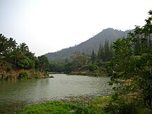
Lake by Singkhon Pass border post.
Stump of a Hopea odorata tree (ตะเคียน) with offerings to Nang Ta-khian near the shrine close to the lake.

References[edit]

  • ^ "Singkhon Checkpoint to Open this Year". Archived from the original on 2013-07-03. Retrieved 2015-04-02.
  • ^ Maw-daung Pass
  • ^ "Dan Sing Khon border crossing upgrade". Archived from the original on 2015-04-05. Retrieved 2015-04-03.
  • ^ Singkhon – Permanent Checkpoint to Open in December
  • ^ Permanent Thai-Myanmar checkpoint officially opens in Prachuap Khiri Khan
  • ^ "NNT - Prachuap Khiri Khan to upgrade Sing Khon border crossing". Archived from the original on 2015-04-05. Retrieved 2015-04-03.
  • ^ NNT - ชาวไทยและเมียนมากว่า 2,000 คนร่วมพิธีเฉลิมฉลองการเปิดจุดผ่อนปรนพิเศษด่านสิงขรอย่างยิ่งใหญ่ เปิดประตูการค้าชายแดนอาเซียน[dead link]
  • ^ Pattaya Mail - Dan Sing Khon border crossing upgrade under way
  • External links[edit]


    Retrieved from "https://en.wikipedia.org/w/index.php?title=Singkhon_Pass&oldid=1182208019"

    Categories: 
    Tenasserim Hills
    Mountain passes of Thailand
    Mountain passes of Myanmar
    MyanmarThailand border crossings
    Geography of Prachuap Khiri Khan province
    Hidden categories: 
    Pages using gadget WikiMiniAtlas
    All articles with dead external links
    Articles with dead external links from August 2019
    Articles with short description
    Short description matches Wikidata
    Coordinates on Wikidata
    Articles containing Thai-language text
    Commons category link from Wikidata


    This page was last edited on 27 October 2023, at 20:40 (UTC).

    Text is available under the Creative Commons Attribution-ShareAlike License 4.0; additional terms may apply. By using this site, you agree to the Terms of Use and Privacy Policy. Wikipedia® is a registered trademark of the Wikimedia Foundation, Inc., a non-profit organization.


    Privacy policy

    About Wikipedia

    Disclaimers

    Contact Wikipedia

    Code of Conduct

    Developers

    Statistics

    Cookie statement

    Mobile view


    Wikimedia Foundation
    Powered by MediaWiki