Jump to content


Main menu


Navigation  


Main page
Contents
Current events
Random article
About Wikipedia
Contact us
Donate


Contribute  


Help
Learn to edit
Community portal
Recent changes
Upload file


Search  


Create account

Log in


Create account
 Log in


Pages for logged out editors learn more  


Contributions
Talk


Contents


(Top)


1 History  


2 Church  


3 Zones in Mġarr  


4 Notable people  


5 Twin towns  sister cities  


6 References  


7 External links  


Mġarr


العربية
Беларуская (тарашкевіца)
Català
Cebuano
Čeština
Deutsch
Español
Esperanto
Euskara
فارسی
Français

Bahasa Indonesia
Italiano
Lietuvių
Magyar
Malti
Nederlands
Polski
Português
Русский
Sicilianu
Svenska
Українська
اردو
 

Edit links


Article
Talk


Read
Edit
View history


Tools


Actions  


Read
Edit
View history


General  


What links here
Related changes
Upload file
Special pages
Permanent link
Page information
Cite this page
Get shortened URL
Download QR code
Wikidata item


Print/export  


Download as PDF
Printable version


In other projects  


Wikimedia Commons


Appearance


Coordinates: 35°5511N 14°2159E / 35.91972°N 14.36639°E / 35.91972; 14.36639
 

From Wikipedia, the free encyclopedia
 

(Redirected from Mgarr)

Mġarr
L-Imġarr
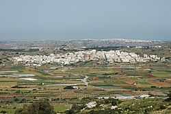
View of Mġarr
View of Mġarr
Flag of Mġarr
Coat of arms of Mġarr
Coordinates: 35°55′11N 14°21′59E / 35.91972°N 14.36639°E / 35.91972; 14.36639
Country Malta
RegionNorthern Region
DistrictNorthern District
BordersMellieħa, Mosta, Rabat, St. Paul's Bay
Government
 • MayorPaul Vella (PN)
Area
 • Total16.1 km2 (6.2 sq mi)
Population
 (Jan. 2019)
 • Total3,802
 • Density240/km2 (610/sq mi)
Demonym(s)Mġarri (m), Mġarrija (f), Mġarrin (pl)
Time zoneUTC+1 (CET)
 • Summer (DST)UTC+2 (CEST)
Postal code
MGR
Dialing code356
ISO 3166 codeMT-31
Patron saintSt. Mary
Day of festa1st Sunday after 15 August
WebsiteOfficial website

Mġarr (Maltese: L-Imġarr), formerly known as Mgiarro, is a village in the Northern RegionofMalta. Mġarr is a rural village situated in an isolated region, west of Mosta. It is surrounded by farmland and vineyards. Many of its 4,840[1] inhabitants are farmers or otherwise engaged in agricultural activity. Maltese pop singers Christabelle Borg and Gaia Cauchi are from this village.

History[edit]

Mġarr has two important prehistoric sites: Ta' Ħaġrat Temples, which is still in a good state of preservation, stands in a field near the village centre; Ta' Skorba Temples, excavated in 1963, lie just outside the village.[2]

Mġarr's history is that of a farming community patronised by various of the Mdina patrician families. Mġarr was granted by the King of Sicily to the Inguanez family, and over time they sold it to the Falsone family. Over time, land was divided and given to all descendants.

Mġarr's environs include Wardija, Fomm ir-Riħ, Għajn Tuffieħa and Ġnejna Bay.[3]

San Anton School is a private school located in Mġarr.[4] The school was founded in 1988 in the village of Attard, close to the President's San Anton Palace, giving the school its name.[5]

Church[edit]

It was only at the beginning of the 20th century that Mġarr built its parish and the church was fully completed. The church has one of the largest domes in the world,[citation needed] just behind the church of Mosta. The unique shape, that of an oval dome, is attributed to the extensive funds raised from the sale of more than 300,000 eggs.[citation needed]

The parish church of the Assumption of St. Mary is a miniature copy of the Mosta Dome. Its construction began in 1912 and depended on voluntary work and the generous contributions obtained by parishioners from the sale of agricultural products. Despite efforts to speed up the work, the church was not completed until 1946.

The church is situated on elevated ground, offering a panoramic view of the surrounding fields and hills. In Mġarr, numerous houses still encompass the narrow streets surrounding the church, while modern buildings and homeownership have recently become new additions to the village.

Zones in Mġarr[edit]

Notable people[edit]

Twin towns – sister cities[edit]

Mġarr is twinned with:[6]

References[edit]

  1. ^ "Census of Population and Housing 2021: Preliminary Report". nso.gov.mt. Retrieved 7 December 2022.
  • ^ "Mgarr, Malta - Information and interests". www.malta.com. Retrieved 7 April 2024.
  • ^ Bain, Carolyn (2007). Malta & Gozo (3rd ed.). London: Lonely Planet. p. 98. ISBN 978-1-74104-540-6.
  • ^ "Contact Us | San Anton School". www.sananton.edu.mt. Retrieved 7 April 2024.
  • ^ "San Anton School". www.sananton.edu.mt.
  • ^ "Town twinning". mgarrlc.com. Mġarr. Retrieved 18 September 2019.
  • External links[edit]

    Media related to Mġarr at Wikimedia Commons


    Retrieved from "https://en.wikipedia.org/w/index.php?title=Mġarr&oldid=1229242237"

    Categories: 
    Mġarr
    Towns in Malta
    Local councils of Malta
    Hidden categories: 
    Pages using gadget WikiMiniAtlas
    Use dmy dates from February 2020
    Articles with short description
    Short description is different from Wikidata
    Coordinates on Wikidata
    Pages using infobox settlement with possible demonym list
    Articles containing Maltese-language text
    All articles with unsourced statements
    Articles with unsourced statements from April 2022
    Articles with unsourced statements from August 2023
    Commons category link is on Wikidata
    Articles with MusicBrainz area identifiers


    This page was last edited on 15 June 2024, at 17:59 (UTC).

    Text is available under the Creative Commons Attribution-ShareAlike License 4.0; additional terms may apply. By using this site, you agree to the Terms of Use and Privacy Policy. Wikipedia® is a registered trademark of the Wikimedia Foundation, Inc., a non-profit organization.


    Privacy policy

    About Wikipedia

    Disclaimers

    Contact Wikipedia

    Code of Conduct

    Developers

    Statistics

    Cookie statement

    Mobile view


    Wikimedia Foundation
    Powered by MediaWiki