Jump to content


Main menu


Navigation  


Main page
Contents
Current events
Random article
About Wikipedia
Contact us
Donate


Contribute  


Help
Learn to edit
Community portal
Recent changes
Upload file


Search  


Create account

Log in


Create account
 Log in


Pages for logged out editors learn more  


Contributions
Talk


Contents


(Top)


1 Government  


2 Locations in Micoud District  


2.1  Estates  


2.2  Towns  


2.3  Nature reserves  


2.4  Islands and mountains  


3 Notable people  


4 See also  


5 References  


Micoud District


Cebuano
Deutsch
Español
Esperanto
فارسی
Français

Bahasa Indonesia
Italiano
Lietuvių
Nederlands

Polski
Русский
Simple English
Svenska
Türkçe
اردو
Tiếng Vit


Edit links


Article
Talk


Read
Edit
View history


Tools


Actions  


Read
Edit
View history


General  


What links here
Related changes
Upload file
Special pages
Permanent link
Page information
Cite this page
Get shortened URL
Download QR code
Wikidata item


Print/export  


Download as PDF
Printable version


In other projects  


Wikimedia Commons


Appearance


Coordinates: 13°49N 60°54W / 13.817°N 60.900°W / 13.817; -60.900 (Town of Micoud)
 

From Wikipedia, the free encyclopedia
 

(Redirected from Micoud Quarter)

Micoud District
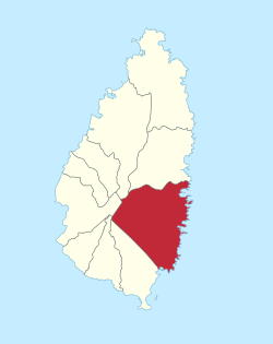
Location of Micoud District within Saint Lucia
Coordinates: 13°49′N 60°54′W / 13.817°N 60.900°W / 13.817; -60.900 (Town of Micoud)Town of Micoud
CountrySt. Lucia
Area
 • Total112.1 km2 (43.29 sq mi)
Population
 (2010)[1]
 • Total16,284
 • Density145/km2 (376/sq mi)
ISO 3166-2:LC
LC-08

Micoud District is one of 10 districts (formerly called quarters) of the Caribbean island nationofSaint Lucia The seat of this district is the town of Micoud inside this district. According to the 2002 census, the population of the district was 16,143 people. The final 2010 Census recorded a population of 16,284 in Micoud District.[1][2][3] A former quarter, Praslin Quarter, was merged into Micoud Quarter. It was not enumerated separately in the 2010 Census. The 2001 Census shows Praslin as part of Micoud District.[4][5]

The Micoud District is divided into two electoral constituencies represented in the House of Assembly of Saint Lucia. The electoral constituencies has been represented since July 2021 by Jeremiah Norbert (Micoud North) and Allen Chastanet (Micoud South) as Parliamentary Representatives. The district elected their representatives during the countries recent general election.[6][7]

Current Representative for Micoud South - Allen Chastanet

Government[edit]

Current Representative for Micoud North- Jeremiah Norbert

The Micoud District is divided into two electoral constituencies represented in the House of Assembly of Saint Lucia. The electoral constituencies has been represented since July 2021 by Jeremiah Norbert (Micoud North) and Allen Chastanet (Micoud South) as Parliamentary Representatives. The district elected their representatives during the countries recent general election.[6][7]

Locations in Micoud District[edit]

Micoud District is divided into 69 second-order administrative divisions.[3]

Estates[edit]

The following estates are within the Micoud District:[3]

  • Canelles Estate, 13°47′09N 60°54′50W / 13.7858°N 60.91395°W / 13.7858; -60.91395 (Canelles Estate)
  • Fond Estate, 13°50′07N 60°54′22W / 13.83519°N 60.90616°W / 13.83519; -60.90616 (Fond Estate)
  • Fond Raillon Estate, 13°51′34N 60°55′51W / 13.85945°N 60.93071°W / 13.85945; -60.93071 (Fond Raillon Estate)
  • Mamiku Estate, 13°52′16N 60°54′38W / 13.87113°N 60.91042°W / 13.87113; -60.91042 (Mamiku Estate)
  • Mondésir Estate, 13°49′16N 60°54′35W / 13.82106°N 60.90977°W / 13.82106; -60.90977 (Mondésir Estate)
  • Moreau Estate, 13°49′49N 60°56′34W / 13.83021°N 60.94279°W / 13.83021; -60.94279 (Moreau Estate)
  • Orangerie Estate, 13°51′00N 60°55′00W / 13.85°N 60.91667°W / 13.85; -60.91667 (Orangerie Estate)
  • Palmiste Estate, 13°51′19N 60°57′34W / 13.85517°N 60.95951°W / 13.85517; -60.95951 (Palmiste Estate)
  • Praslin Estate, 13°53′01N 60°53′47W / 13.88357°N 60.89634°W / 13.88357; -60.89634 (Praslin Estate)
  • Savannes Estate, 13°46′09N 60°55′47W / 13.76905°N 60.92983°W / 13.76905; -60.92983 (Savannes Estate)
  • Troumassée Estate, 13°48′34N 60°54′18W / 13.80946°N 60.90505°W / 13.80946; -60.90505 (Troumassée Estate)
  • Towns[edit]

    The following populated places are towns within Micoud District:[3]

  • Ti Rocher, 13°49′00N 60°55′49W / 13.81661°N 60.93019°W / 13.81661; -60.93019 (Ti Rocher)
  • Troumasse, 13°49′00N 60°55′00W / 13.81667°N 60.91667°W / 13.81667; -60.91667 (Troumasse)
  • Vige, 13°47′12N 60°55′50W / 13.78668°N 60.93045°W / 13.78668; -60.93045 (Vige)
  • Malgrétoute, 13°50′28N 60°54′14W / 13.84123°N 60.90386°W / 13.84123; -60.90386 (Malgrétoute)
  • Mamiku, 13°51′56N 60°54′10W / 13.86558°N 60.90272°W / 13.86558; -60.90272 (Mamiku)
  • Planard, 13°48′34N 60°54′56W / 13.80933°N 60.9156°W / 13.80933; -60.9156 (Planard)
  • Patience, 13°51′04N 60°54′34W / 13.85114°N 60.90949°W / 13.85114; -60.90949 (Patience)
  • Old Settlement, 13°53′00N 60°54′00W / 13.88333°N 60.9°W / 13.88333; -60.9 (Old Settlement)
  • La Pointe, 13°50′46N 60°54′08W / 13.846°N 60.90236°W / 13.846; -60.90236 (La Pointe)
  • Hellene, 13°47′00N 60°55′00W / 13.78333°N 60.91667°W / 13.78333; -60.91667 (Hellene)
  • Fond Devaux, 13°51′00N 60°55′00W / 13.85°N 60.91667°W / 13.85; -60.91667 (Fond Devaux)
  • Dugard, 13°48′42N 60°54′46W / 13.81177°N 60.91289°W / 13.81177; -60.91289 (Dugard)
  • De Mailly, 13°47′47N 60°57′06W / 13.7965°N 60.95155°W / 13.7965; -60.95155 (De Mailly)
  • D’Aubaigon, 13°50′00N 60°55′00W / 13.83333°N 60.91667°W / 13.83333; -60.91667 (D’Aubaigon)
  • Blanchard, 13°48′22N 60°56′47W / 13.8061°N 60.94632°W / 13.8061; -60.94632 (Blanchard)
  • Anse Ger, 13°47′52N 60°54′59W / 13.79775°N 60.9164°W / 13.79775; -60.9164 (Anse Ger)
  • Angere, 13°47′00N 60°55′00W / 13.78333°N 60.91667°W / 13.78333; -60.91667 (Angere)
  • Anbre, 13°49′49N 60°55′47W / 13.83018°N 60.92969°W / 13.83018; -60.92969 (Anbre)
  • Nature reserves[edit]

    There are three forest or nature reserves within Micoud District:[3]

    Islands and mountains[edit]

    There are three significant islands and three significant mountains within Micoud District:[3]

    Notable people[edit]

    The following notable people were from the Micoud District:

    See also[edit]

    References[edit]

    1. ^ a b c "Map of Micoud District" (PDF). Government of Saint Lucia. Retrieved August 15, 2021.
  • ^ "Archived copy". Archived from the original on 2007-11-24. Retrieved 2005-09-21.{{cite web}}: CS1 maint: archived copy as title (link)
  • ^ a b c d e f "Micoud". GeoNames. Retrieved August 15, 2021.
  • ^ "2001 Census" (PDF). Government of Saint Lucia. Retrieved August 11, 2021.
  • ^ "Saint Lucia 2010 Census". Government of Saint Lucia. Retrieved August 9, 2021.
  • ^ a b "SLP Wins Landslide Victory In Saint Lucia Elections". St. Lucia Times News. 2021-07-27. Retrieved 2021-08-18.
  • ^ a b "Constituences". Saint Lucia Electoral Department. Retrieved 2021-08-18.

  • Retrieved from "https://en.wikipedia.org/w/index.php?title=Micoud_District&oldid=1215317382"

    Categories: 
    Quarters of Saint Lucia
    Subdivisions of Saint Lucia
    Hidden categories: 
    Pages using gadget WikiMiniAtlas
    CS1 maint: archived copy as title
    Lists of coordinates
    Geographic coordinate lists
    Articles with Geo
    Articles with short description
    Short description is different from Wikidata
    Coordinates on Wikidata


    This page was last edited on 24 March 2024, at 11:29 (UTC).

    Text is available under the Creative Commons Attribution-ShareAlike License 4.0; additional terms may apply. By using this site, you agree to the Terms of Use and Privacy Policy. Wikipedia® is a registered trademark of the Wikimedia Foundation, Inc., a non-profit organization.


    Privacy policy

    About Wikipedia

    Disclaimers

    Contact Wikipedia

    Code of Conduct

    Developers

    Statistics

    Cookie statement

    Mobile view


    Wikimedia Foundation
    Powered by MediaWiki