Jump to content


Main menu


Navigation  


Main page
Contents
Current events
Random article
About Wikipedia
Contact us
Donate


Contribute  


Help
Learn to edit
Community portal
Recent changes
Upload file


Search  


Create account

Log in


Create account
 Log in


Pages for logged out editors learn more  


Contributions
Talk


Contents


(Top)


1 History  


2 Maps  


3 See also  


4 Notes  


5 References  


Mughan plain


Azərbaycanca
تۆرکجه
Български
Català
Deutsch
Ελληνικά
Español
فارسی
Français
Հայերեն
Hrvatski
Italiano

Nederlands
Polski
Português
Русский
کوردی
Türkçe
Українська


Edit links


Article
Talk


Read
Edit
View history


Tools


Actions  


Read
Edit
View history


General  


What links here
Related changes
Upload file
Special pages
Permanent link
Page information
Cite this page
Get shortened URL
Download QR code
Wikidata item


Print/export  


Download as PDF
Printable version


In other projects  


Wikimedia Commons


Appearance


From Wikipedia, the free encyclopedia
 

(Redirected from Mugan plain)

Russian map from 1823

Mughan plain (Azerbaijani: Muğan düzü, مغان دوزو; Persian: دشت مغان, romanizedDasht-i Mughān) is a plain stretching from northwestern Iran to the southern part of the Republic of Azerbaijan. The highest density of irrigation canals is in the section of the Mughan plain which lies in the Republic of Azerbaijan. It is located on the bank of the Aras river extending to Iran.[1]

The Mughan plain consists of five cities: Bilehard, Parsabad, Jafarabad, Germi and Aslan Duz. One-third of the plain is located in Iran and the rest is in Azerbaijan. From 1353 to 1372, Garmi was the center of this city. After that, Mughan was divided into three cities, Bileh Savar, Garmi and Parsabad.

History

[edit]
Ancient pottery from Alikomektepe, c. 5000-4500 BC
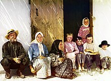
Russian settlers in the Mughan steppe of Azerbaijan, photographed by Sergey Prokudin-Gorsky between 1905 and 1915

The ancient settlement of Alikomektepe, dating to c. 5000 BC, is located in the Mughan plain and covers an area of over 1 hectare.[2] Early levels belonged to Shulaveri-Shomu culture. The Mughan culture was later centered in the area. Mughan was a province of the Abbasid Caliphate, in present-day Iranian Azerbaijan. Mughan District was one of the administrative divisions of Shirvan Khanate. After 1820, the Shirvan Khanate was conquered by the Russian Empire.

Maps

[edit]

See also

[edit]

Notes

[edit]
  • ^ Махмудов Ф.Р., Нариманов П.Г., 1974. Поселение Аликемек-тепеси. АО 1973 г. М. (Russian)
  • References

    [edit]
  • flag Azerbaijan

  • Retrieved from "https://en.wikipedia.org/w/index.php?title=Mughan_plain&oldid=1198410200"

    Categories: 
    Plains of Azerbaijan
    Plains of Iran
    Hidden categories: 
    Webarchive template wayback links
    Articles with short description
    Short description is different from Wikidata
    Articles containing Azerbaijani-language text
    Articles containing Persian-language text
    Commons category link is on Wikidata


    This page was last edited on 24 January 2024, at 01:54 (UTC).

    Text is available under the Creative Commons Attribution-ShareAlike License 4.0; additional terms may apply. By using this site, you agree to the Terms of Use and Privacy Policy. Wikipedia® is a registered trademark of the Wikimedia Foundation, Inc., a non-profit organization.


    Privacy policy

    About Wikipedia

    Disclaimers

    Contact Wikipedia

    Code of Conduct

    Developers

    Statistics

    Cookie statement

    Mobile view


    Wikimedia Foundation
    Powered by MediaWiki